GROUND WATER ATLAS of the UNITED STATES
Illinois, Indiana, Kentucky, Ohio, Tennessee
HA 730-K
Interior Low Plateaus aquifers
There are two different files for each illustration
- A 72 ppi GIF file, suitable for screen viewing is accessed through
the thumbnail image
- An eps file, suitable for downloading to be printed or edited is accessed
through the "eps file" link. Most files are Adobe Illustrator
6.0, exceptions are noted. These files have been compressed with GNU's
gzip utility. If your web browser defaults to a screen display of the file,
turn on the "Load to local disk" option before downloading. Download
and process these eps files as ascii, not binary.
Pennsylvanian aquifers
Hydrogeologic setting
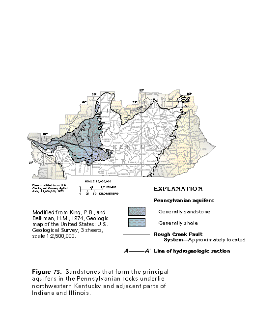
Figure 73 Map of Pennsylvanian aquifers (33K)
 editable eps file k073.eps.gz
(116K compressed)
editable eps file k073.eps.gz
(116K compressed)
Figure 74 Cross section of Pennsylvanian aquifers and depth to
water (17K)
 editable eps file k074.eps.gz
(50K compressed)
editable eps file k074.eps.gz
(50K compressed)
Figure 75 Correlation chart (17K)
 editable eps file k075.eps.gz
(17K compressed)
editable eps file k075.eps.gz
(17K compressed)
Aquifer characteristics and well yields
Ground-water quality
Figure 76 Water quality chart for the western coal field region,
Kentucky (17K)
 editable eps file k076.eps.gz
(17K compressed)
editable eps file k076.eps.gz
(17K compressed)
Fresh ground-water withdrawals
Figure 77 Chart showing use of fresh ground-water withdrawals
during 1985 (17K)
 editable eps file k077.eps.gz
(17K compressed)
editable eps file k077.eps.gz
(17K compressed)
 editable eps file k073.eps.gz
(116K compressed)
editable eps file k073.eps.gz
(116K compressed)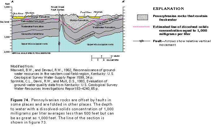 editable eps file k074.eps.gz
(50K compressed)
editable eps file k074.eps.gz
(50K compressed)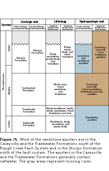 editable eps file k075.eps.gz
(17K compressed)
editable eps file k075.eps.gz
(17K compressed)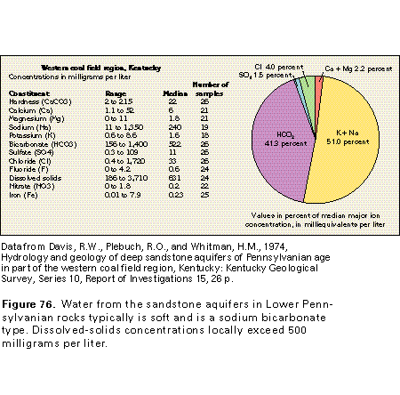 editable eps file k076.eps.gz
(17K compressed)
editable eps file k076.eps.gz
(17K compressed)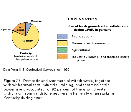 editable eps file k077.eps.gz
(17K compressed)
editable eps file k077.eps.gz
(17K compressed)