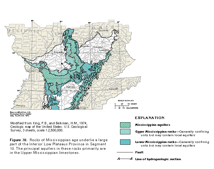
Figure 78 Map of Mississippian aquifers and rocks (50K)
 editable eps file k078.eps.gz
(215K compressed)
editable eps file k078.eps.gz
(215K compressed)
Figure 78 Map of Mississippian aquifers and rocks (50K)
editable eps file k078.eps.gz
(215K compressed)
 editable eps file k079.eps.gz
(17K compressed)
editable eps file k079.eps.gz
(17K compressed) editable eps file k080.eps.gz
(33K compressed)
editable eps file k080.eps.gz
(33K compressed) editable eps file k081.eps.gz
(50K compressed)
editable eps file k081.eps.gz
(50K compressed) editable eps file k082.eps.gz
(99K compressed)
editable eps file k082.eps.gz
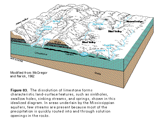
(99K compressed)Figure 83 Diagramatic section showing the dissolution of limestone
(33K)
 This illustration contains a placed image. Download the Adobe Illustrator
6 eps file k083.eps.gz (132K compressed)
which contains an imbedded Adobe Photoshop 3 (eps) file. You may also want
to download the editable Photoshop
file k083psh.eps.gz (132K compressed)
This illustration contains a placed image. Download the Adobe Illustrator
6 eps file k083.eps.gz (132K compressed)
which contains an imbedded Adobe Photoshop 3 (eps) file. You may also want
to download the editable Photoshop
file k083psh.eps.gz (132K compressed)
 editable eps file k084.eps.gz
(99K compressed)
editable eps file k084.eps.gz
(99K compressed) This illustration contains a placed image. Download the Adobe Illustrator
6 eps file k085.eps.gz (8.1M compressed)
which contains an imbedded Adobe Photoshop 3 (eps) file. You may also want
to download the editable Photoshop file k085psh.eps.gz
(8.1M compressed)
This illustration contains a placed image. Download the Adobe Illustrator
6 eps file k085.eps.gz (8.1M compressed)
which contains an imbedded Adobe Photoshop 3 (eps) file. You may also want
to download the editable Photoshop file k085psh.eps.gz
(8.1M compressed) 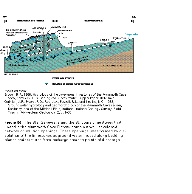 editable eps file k086.eps.gz
(83K compressed)
editable eps file k086.eps.gz
(83K compressed)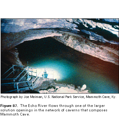 This illustration contains a placed image. Download the Adobe Illustrator
6 eps file k087.eps.gz (8.3M compressed)
which contains an imbedded Adobe Photoshop 3 (eps) file. You may also want
to download the editable Photoshop
file k087psh.eps.gz (8.3M compressed)
This illustration contains a placed image. Download the Adobe Illustrator
6 eps file k087.eps.gz (8.3M compressed)
which contains an imbedded Adobe Photoshop 3 (eps) file. You may also want
to download the editable Photoshop
file k087psh.eps.gz (8.3M compressed) 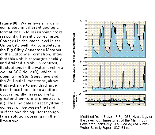 editable eps file k088.eps.gz
(17K compressed)
editable eps file k088.eps.gz
(17K compressed)
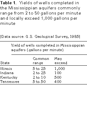
Table 1 Table of yield of wells completed in the Mississippian aquifers
(17K)
 editable eps file ktab1.eps.gz
(17K compressed)
editable eps file ktab1.eps.gz
(17K compressed)
 editable eps file k089.eps.gz
(50K compressed)
editable eps file k089.eps.gz
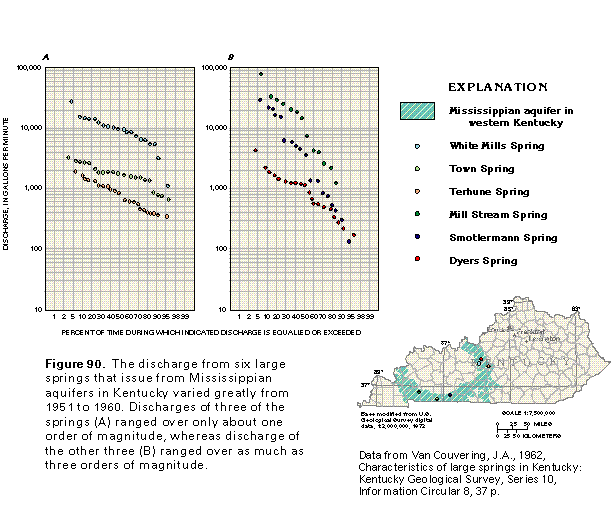
(50K compressed)Figure 90 Graph showing the discharge of six large springs (33K)
 editable eps file k090.eps.gz
(66K compressed)
editable eps file k090.eps.gz
(66K compressed)
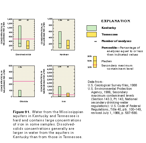
Figure 91 Water quality graph (17K)
 editable eps file k091.eps.gz
(17K compressed)
editable eps file k091.eps.gz
(17K compressed)
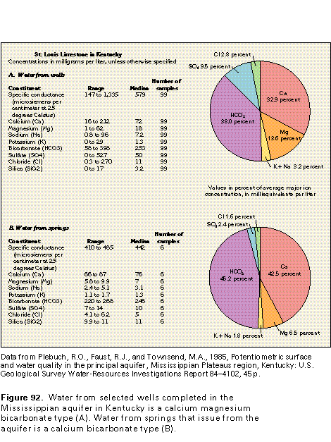
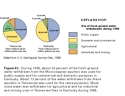
Figure 92 Water quality chart for the St. Louis Limestone in Kentucky
(33K)
 editable eps file k092.eps.gz
(17K compressed)
editable eps file k092.eps.gz
(17K compressed)
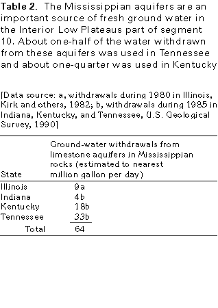
Table 2 Table showing ground-water withdrawals from limestone
(17K)
 editable eps file ktab2.eps.gz
(17K compressed)
editable eps file ktab2.eps.gz
(17K compressed)
 editable eps file k093.eps.gz
(17K compressed)
editable eps file k093.eps.gz
(17K compressed)