GROUND WATER ATLAS of the UNITED STATES
Illinois, Indiana, Kentucky, Ohio, Tennessee
HA 730-K
Interior Low Plateaus aquifers
There are two different files for each illustration
- A 72 ppi GIF file, suitable for screen viewing is accessed through
the thumbnail image
- An eps file, suitable for downloading to be printed or edited is accessed
through the "eps file" link. Most files are Adobe Illustrator
6.0, exceptions are noted. These files have been compressed with GNU's
gzip utility. If your web browser defaults to a screen display of the file,
turn on the "Load to local disk" option before downloading. Download
and process these eps files as ascii, not binary.
Devonian, Silurian, and Ordovician aquifers
Hydrogeologic setting
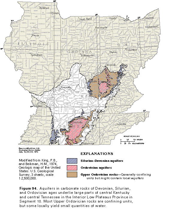
Figure 94 Map of Devonian, Silurian, and Ordovician aquifers (50K)
 editable eps file k094.eps.gz
(182K compressed)
editable eps file k094.eps.gz
(182K compressed)
Figure 95 Correlation chart (33K)
 editable eps file k095.eps.gz
(17K compressed)
editable eps file k095.eps.gz
(17K compressed)
Table 3 Table showing wells that obtain
fresh ground water from carbonate rocks (17K)
 editable eps file ktab3.eps.gz
(17K compressed)
editable eps file ktab3.eps.gz
(17K compressed)
Figure 96 Cross section of Silurian
and Ordovician rocks that contain freshwater (17K)
 editable eps file k096.eps.gz
(50K compressed)
editable eps file k096.eps.gz
(50K compressed)
Figure 97 Cross section showing the
direction of ground-water movement (17K)
 editable eps file k097.eps.gz
(33K compressed)
editable eps file k097.eps.gz
(33K compressed)
Yields of wells and discharges of springs
Table 4 Table showing yields of wells completed in the limestone
and dolomite aquifers in ordovician rocks (17K)
 editable eps file ktab4.eps.gz
(17K compressed)
editable eps file ktab4.eps.gz
(17K compressed)
Figure 98 Graph and map comparing
the discharge of four large springs (33K)
 editable eps file k098.eps.gz
(50K compressed)
editable eps file k098.eps.gz
(50K compressed)
Ground-water quality
Figure 99 Water quality graph (17K)
 editable eps file k099.eps.gz
(17K compressed)
editable eps file k099.eps.gz
(17K compressed)
Figure 100 Water quality chart for Ordovician aquifers in Kentucky
(33K)
 editable eps file k100.eps.gz
(17K compressed)
editable eps file k100.eps.gz
(17K compressed)
Fresh ground-water withdrawals
Figure 101 Chart showing the use of fresh ground-water withdrawals
during 1985 (17K)
 editable eps file k101.eps.gz
(17K compressed)
editable eps file k101.eps.gz
(17K compressed)
 editable eps file k094.eps.gz
(182K compressed)
editable eps file k094.eps.gz
(182K compressed)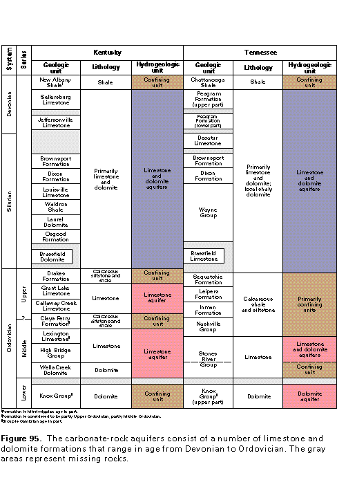 editable eps file k095.eps.gz
(17K compressed)
editable eps file k095.eps.gz
(17K compressed)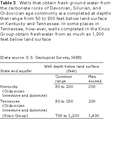 editable eps file ktab3.eps.gz
(17K compressed)
editable eps file ktab3.eps.gz
(17K compressed)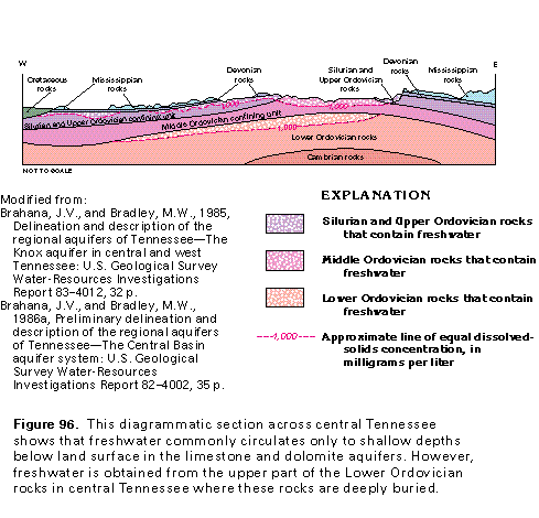 editable eps file k096.eps.gz
(50K compressed)
editable eps file k096.eps.gz
(50K compressed)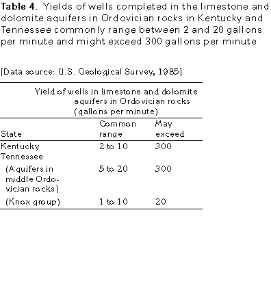 editable eps file ktab4.eps.gz
(17K compressed)
editable eps file ktab4.eps.gz
(17K compressed)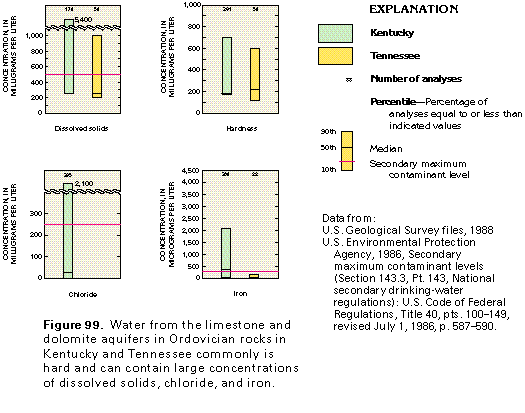 editable eps file k099.eps.gz
(17K compressed)
editable eps file k099.eps.gz
(17K compressed)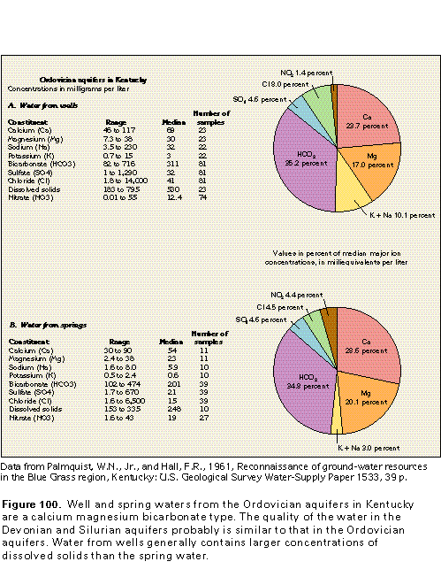 editable eps file k100.eps.gz
(17K compressed)
editable eps file k100.eps.gz
(17K compressed)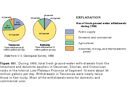 editable eps file k101.eps.gz
(17K compressed)
editable eps file k101.eps.gz
(17K compressed)