GROUND WATER ATLAS of the UNITED STATES
Delaware, Maryland, New Jersey, North Carolina, Pennsylvania, Virginia,
West Virginia
HA 730-L
Appalachian Plateaus aquifers
There are two different files for each illustration
- A 72 ppi GIF file, suitable for screen viewing is accessed through
the thumbnail image
- An eps file, suitable for downloading to be printed or edited is accessed
through the "eps file" link. Most files are Adobe Illustrator
6.0, exceptions are noted. These files have been compressed with GNU's
gzip utility. If your web browser defaults to a screen display of the file,
turn on the "Load to local disk" option before downloading. Download
and process these eps files as ascii, not binary.
Ground-water quality
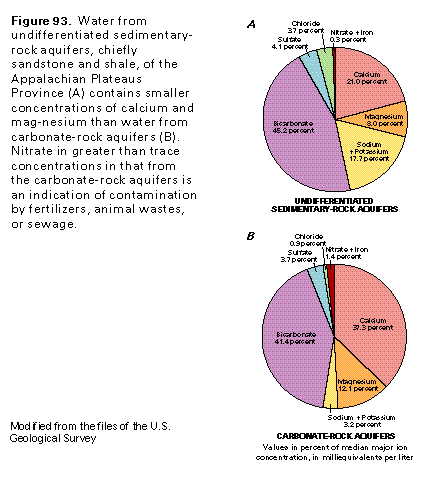
Figure 93 Charts showing chemical composition (17K)
 editable eps file L093.eps.gz
(17K compressed)
editable eps file L093.eps.gz
(17K compressed)
Figure 94 Hydrogeologic section (17K)
 editable eps file L094.eps.gz
(17K compressed)
editable eps file L094.eps.gz
(17K compressed)
Figure 95 Photo of contamination from an abandoned
underground coal mine (50K)
 This illustration contains a placed image. Download the Adobe Illustrator
6 eps file L095.eps.gz (5.6M compressed)
which contains an imbedded Adobe Photoshop 3 (eps) file. You may also want
to download the editable Photoshop
file L095psh.eps.gz (5.6M compressed)
This illustration contains a placed image. Download the Adobe Illustrator
6 eps file L095.eps.gz (5.6M compressed)
which contains an imbedded Adobe Photoshop 3 (eps) file. You may also want
to download the editable Photoshop
file L095psh.eps.gz (5.6M compressed)
 editable eps file L093.eps.gz
(17K compressed)
editable eps file L093.eps.gz
(17K compressed)  editable eps file L094.eps.gz
(17K compressed)
editable eps file L094.eps.gz
(17K compressed) 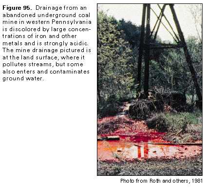 This illustration contains a placed image. Download the Adobe Illustrator
6 eps file L095.eps.gz (5.6M compressed)
which contains an imbedded Adobe Photoshop 3 (eps) file. You may also want
to download the editable Photoshop
file L095psh.eps.gz (5.6M compressed)
This illustration contains a placed image. Download the Adobe Illustrator
6 eps file L095.eps.gz (5.6M compressed)
which contains an imbedded Adobe Photoshop 3 (eps) file. You may also want
to download the editable Photoshop
file L095psh.eps.gz (5.6M compressed)