GROUND WATER ATLAS of the UNITED STATES
Delaware, Maryland, New Jersey, North Carolina, Pennsylvania, Virginia,
West Virginia
HA 730-L
Piedmont and Blue Ridge aquifers
There are two different files for each illustration
- A 72 ppi GIF file, suitable for screen viewing is accessed through
the thumbnail image
- An eps file, suitable for downloading to be printed or edited is accessed
through the "eps file" link. Most files are Adobe Illustrator
6.0, exceptions are noted. These files have been compressed with GNU's
gzip utility. If your web browser defaults to a screen display of the file,
turn on the "Load to local disk" option before downloading. Download
and process these eps files as ascii, not binary.
Carbonate-rock aquifers
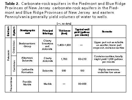
Table 2 Carbonate-rock table (17K)
 editable eps file Ltab2.eps.gz
(17K compressed)
editable eps file Ltab2.eps.gz
(17K compressed)
Table 3 Carbonate-rock table (17K)
 editable eps file Ltab3.eps.gz
(17K compressed)
editable eps file Ltab3.eps.gz
(17K compressed)
Table 4 Carbonate-rock table (17K)
 editable eps file Ltab4.eps.gz
(17K compressed)
editable eps file Ltab4.eps.gz
(17K compressed)
 editable eps file Ltab2.eps.gz
(17K compressed)
editable eps file Ltab2.eps.gz
(17K compressed) 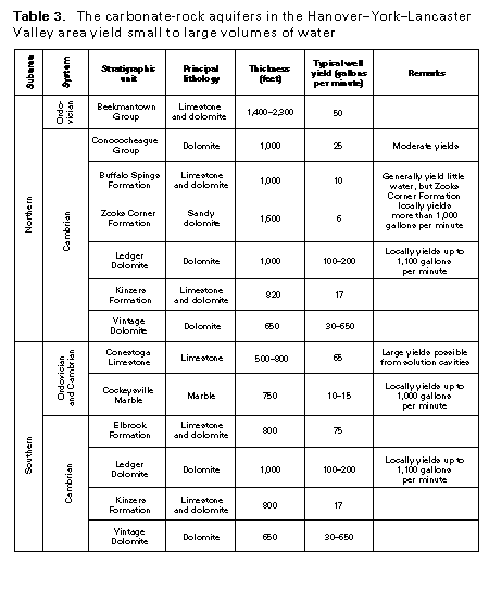 editable eps file Ltab3.eps.gz
(17K compressed)
editable eps file Ltab3.eps.gz
(17K compressed)  editable eps file Ltab4.eps.gz
(17K compressed)
editable eps file Ltab4.eps.gz
(17K compressed)