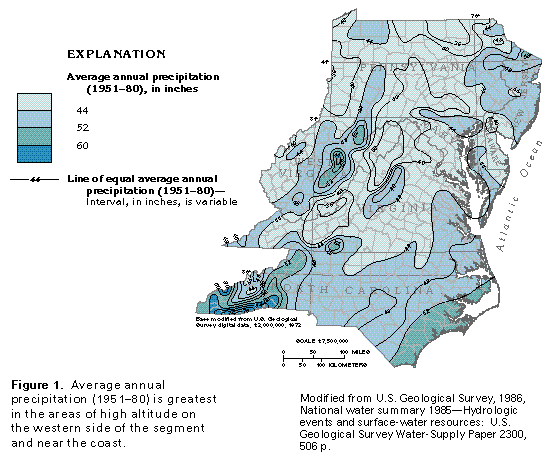
Figure 1 Map showing average annual precipitation (33K)
 editable eps file L001.eps.gz
(248K compressed)
editable eps file L001.eps.gz
(248K compressed)
Figure 1 Map showing average annual precipitation (33K)
editable eps file L001.eps.gz
(248K compressed)
 editable eps file L002.eps.gz
(248K compressed)
editable eps file L002.eps.gz
(248K compressed)  editable eps file L003.eps.gz
(281K compressed)
editable eps file L003.eps.gz
(281K compressed)  This illustration contains a placed image. Download the Adobe Illustrator
6 eps file L004.eps.gz (7.4M compressed)
which contains an imbedded Adobe Photoshop 3 (eps) file. You may also want
to download the editable Photoshop
file L004psh.eps.gz (7.4M compressed)
This illustration contains a placed image. Download the Adobe Illustrator
6 eps file L004.eps.gz (7.4M compressed)
which contains an imbedded Adobe Photoshop 3 (eps) file. You may also want
to download the editable Photoshop
file L004psh.eps.gz (7.4M compressed)  This illustration contains a placed image. Download the Adobe Illustrator
6 eps file L005.eps.gz (8.3M compressed)
which contains an imbedded Adobe Photoshop 3 (eps) file. You may also want
to download the editable Photoshop
file L005psh.eps.gz (8.3M compressed)
This illustration contains a placed image. Download the Adobe Illustrator
6 eps file L005.eps.gz (8.3M compressed)
which contains an imbedded Adobe Photoshop 3 (eps) file. You may also want
to download the editable Photoshop
file L005psh.eps.gz (8.3M compressed)