INTRODUCTION
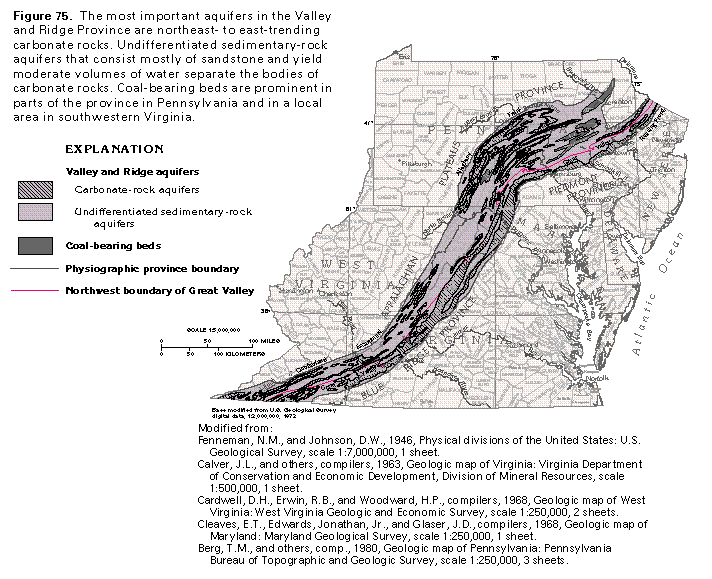
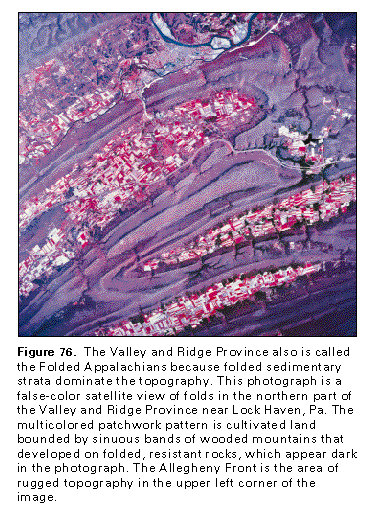
Aquifers in the Valley and Ridge Physiographic Province consist of permeable rocks within a sequence of folded and faulted sedimentary formations of Paleozoic age. The upper strata were folded into anticlines and synclines as they slid over underlying beds along large, nearly horizontal faults. The folded rocks form a series of parallel valleys separated by steep to well-rounded ridges that rise from about 100 to 2,000 feet above the valley floors. The province is named for these al-ternating valleys and ridges that trend northeastward from southwestern Virginia to east-central Pennsylvania and then eastward toward northern New Jersey (fig. 75) in Segment 11. The province extends southwestward through Tennessee (Segment 10 of this Atlas) into northern Georgia and Alabama (Segment 6 of this Atlas) and is briefly discussed in the chapters that describe aquifers in these segments. The province also is called the Folded Appalachians because folded strata dominate the topography (fig. 76). The same Paleozoic formations of the Valley and Ridge Province are present in the Appalachian Plateaus Province to the west, where they are much more gently folded and nearly flat-lying in places. The rocks of the Valley and Ridge Province are chiefly sandstone, shale, and carbonate rocks; locally, coal-bearing beds are present. A thick cover of regolith has developed on the rocks, particularly in the valleys.
The Valley and Ridge Province reaches a maximum width of about 80 miles in central Pennsylvania and is bounded by the higher land surfaces of the Blue Ridge and the Piedmont Provinces on the southeast and the Appalachian Plateaus Province on the northwest. In most places, the Valley and Ridge is separated from the Appalachian Plateaus by an escarpment called the Allegheny Front in Pennsylvania, Maryland, and West Virginia and the Cumberland Escarpment in Virginia (fig. 75).
The Great Valley is the most pronounced and persistent valley in the Valley and Ridge Province. It is floored with easily eroded rock, such as shale, slate, or carbonate rocks. The valley generally ranges from 10 to 20 miles wide but is much narrower in and near Roanoke County, Va. Part of the eastern boundary of the Great Valley is a zone of thrust faulting; crystalline rocks of the Blue Ridge Province have been shoved northwestward tens of miles over Paleozoic sedimentary rocks in places. The western boundary of the valley is the first persistent mountainous ridge of resistant sedimentary rock. The part of the Valley and Ridge northwest of the Great Valley consists of persistent mountain ridges underlain by resistant sandstone, conglomerate, and quartzite, which alternate with valleys floored with shale or slate and carbonate rocks.
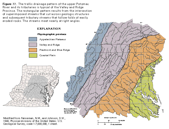
Drainage patterns in the Valley and Ridge Province directly reflect the alternating bands of resistant and easily eroded rocks in the folded strata of the province. Major streams and their tributaries intersect at right angles to form a rectangular stream network called a trellis drainage pattern (fig. 77). For example, in the Shenandoah Valley, which is part of the Great Valley in Virginia and West Virginia, the Shenandoah River flows northward to join the Potomac River. The Shenandoah River follows a band of weak and soluble rocks as the course of least resistance, as do most of the other rivers in the Valley and Ridge. Such streams are called subsequent streams and their courses are determined by regional geologic structure as expressed by the patterns of resistant and weak rocks.
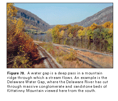
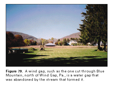
A few major rivers, however, such as the Lehigh and the Susquehanna Rivers in Pennsylvania, the Delaware River between Pennsylvania and New Jersey, and part of the Potomac River in West Virginia, Maryland, and Virginia, cut directly across the ridges and valleys (fig. 75). Such streams are called superimposed streams. The Susquehanna River, for example, crosses six major ridges within 50 miles upstream from Harrisburg, Pa.. The notch carved through a resistant ridge by a river is called a water gap (fig. 78). When a stream no longer flows through a water gap, usually because the stream has been captured by headward erosion of a larger stream, the abandoned water gap is called a wind gap (fig. 79).
GEOLOGIC STRUCTURE
The geologic structure of the Valley and Ridge Province is complex, but the process principally responsible for the present configuration of the rock layers was displacement to the northwest. Some movement took place along low-angle reverse faults; rocks of the Blue Ridge Province and the Reading Prong were thrust northwestward over layered sedimentary rocks of the Valley and Ridge Province for tens of miles, and the layered rocks, in turn, were broken into slices that slid over each other. At and near the land surface, the beds were folded into nearly parallel, northeast-trending anticlines and synclines. In some areas, the folded beds are bounded below by nearly horizontal thrust faults. At the time of deformation, slippage occurred along bedding planes; accordingly, the folded beds above were detached from those below.
Folding is most intense in the parts of the Valley and Ridge Province in New Jersey and central to northeastern Pennsylvania. Because of the intense deformation, cleavage in places is more prominent than bedding, and some of the rocks have undergone low-grade metamorphism. In the Valley and Ridge Province in southwestern Virginia and farther to the southwest in Tennessee, folding is less intense, but major faults are common, and vertical to overturned beds appear in many places, particularly on the northwestern sides of anticlines. The western boundary of the Valley and Ridge Province is marked by a rather abrupt reduction in the deformation of the beds. This corresponds approximately with the Allegheny Front, which marks the boundary between the Valley and Ridge and the Appalachian Plateaus Province. Faults occur at the boundary in some places, but have not been identified everywhere.
The present Appalachian Mountains are merely the roots of ancient mountains. Only parts of the original folds remain, and the mountain ridges are the eroded edges of resistant rock layers, principally hard sandstone, conglomerate, or quartzite. Axes of anticlines commonly are valleys, especially where the rock that forms the center of the upfold has little resistance to erosion. Axes of synclines commonly coincide with ridges or mountains where the rock at the center of the downfold is resistant. Formations that have been eroded away elsewhere might be preserved in synclines. Broad folds, whether syn-clines or anticlines, can appear as a series of narrow ridges and valleys produced by the differences in erodability of their rock layers.
HYDROGEOLOGIC UNITS
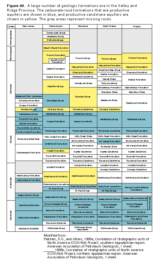
The principal aquifers in the Valley and Ridge Province from Virginia through New Jersey are carbonate rocks and sandstones that range in age from early to late Paleozoic (fig. 80). Not all the geologic formations recognized in each of the States are shown; some formations that are thin or are of small extent are omitted. Most of the more productive aquifers are in carbonate rocks, primarily limestone, and most are in valleys. Although the water-yielding character of the carbonate rocks depends on the degree of fracturing and development of solution cavities in the rock, the limestone formations generally yield moderate to large volumes of water. Sandstone formations also can yield large quantities of water to wells where the sandstone is fractured. Locally, fractured shale beds form productive aquifers. Because the rocks change in lithology, thickness, water-yielding character, and formation name from place to place, it is difficult to make statements about the water-yielding character of any of the named stratigraphic units that apply throughout Segment 11. Generally, however, limestone aquifers predominate in rocks of Cambrian, early Ordovician, late Silurian, and early Devonian age (fig. 80), whereas sandstone aquifers are prominent in rocks of middle and late Ordovician, middle Devonian, and younger age.
The sedimentary formations of the Valley and Ridge Province are commonly thick and steeply tilted; thus, a water well usually penetrates only the consolidated rock formation exposed at the surface. Therefore geologic maps are good guides to the type of rock from which a well can withdraw water.
The Great Valley makes up most of the Valley and Ridge Province in New Jersey and is floored with shale and carbonate rock of early Paleozoic age. A thick sequence of carbonate rocks that consist of the Leithsville Formation, the Allentown Dolomite, and the Beekmantown Group contains the most productive aquifers. Yields of as much as 850 gallons per minute have been reported for wells that obtain water from combinations of these geologic units. West of the Great Valley, predominately Silurian and Devonian rocks (mostly shale, sandstone, and conglomerate) are exposed. Wells completed in these clastic rocks and in thin limestone units interbedded with them yield 15 to 100 gallons per minute.
The Valley and Ridge Province is widest in Pennsylvania and contains more geologic units than elsewhere in Segment 11 (fig. 80). The Great Valley in Pennsylvania is floored with ower Paleozoic carbonate rocks and shale. Principal water-yielding geologic units are limestone and dolomitic limestone of the Waynesboro Formation through the St. Paul Group (Cambrian and Ordovician ages), with well yields reported to range from 25 to 210 gallons per minute. Yields from sandstone of the Martinsburg Formation, by contrast, only range from 10 to 30 gallons per minute. Northwest of the Great Valley, the uppermost Paleozoic rocks in central to northeastern Pennsylvania are coal-bearing beds of Pennsylvanian age mostly associated with the anthracite coal fields where deeply infolded beds of coal were preserved from erosion. The processes of folding and deep burial drove off most of the volatile content of the bituminous coal in the more intensely folded areas and converted it to anthracite. This conversion did not take place everywhere, however. For example, in south-central Pennsylvania, Pennsylvanian rocks range from 1,000 to 1,500 feet thick in a synclinal mountain in parts of Huntingdon, Bedford, and Fulton Counties (fig. 75), but the coals they contain are closer in rank to bituminous than anthracite. Pennsylvanian rocks consist of sandstone, which is coarse or conglomeratic in some places; gray and black shale and claystone; thin beds of limestone; and coal. Sandstone is more abundant in the Pottsville Group than other geologic units, and yields of wells completed in the Pottsville commonly range from 50 to 100 gallons per minute.
Mississippian rocks in Pennsylvania have a distribution pattern similar to that of Pennsylvanian rocks but have a somewhat wider extent. They consist primarily of shale, sandstone, and conglomerate; yields of wells completed in sandstones of the Mississippian parts of the Mauch Chunk and the Pocono Formations range from 20 to 90 gallons per minute. Devonian rocks are extensively exposed west of the Great Valley in southern Pennsylvania and north and east of the Susquehanna River. The ridges of the province are typically formed on the upturned edges of layers of hard Silurian sandstone and quartzite, but the Silurian section also includes shale and limestone. Yields from limestones of Silurian and Devonian age (Mifflintown Formation through Onondaga Group, fig. 80) commonly range from 20 to 120 gallons per minute to wells; local yields of as much as 1,400 gallons per minute have been reported. Wells completed in sandstones of the Keefer Formation and Oriskany Group yield as much as 120 gallons per minute.
The Valley and Ridge Province extends throughout most of the Maryland Panhandle, but the Great Valley part of the province is restricted to Washington County (fig. 75). The Great Valley in Maryland is floored with predominately carbonate-rock and shale formations of Cambrian and Ordovician age. The principal water-yielding units in the Great Valley are the Tomstown Formation through the Beekmantown Group (fig. 80); well yields commonly range from 25 to 400 gallons per minute. West of the Great Valley, sandstones of Ordovician to Devonian age are the principal aquifers but commonly yield less than 120 gallons per minute; locally, yields of as much as 100 gallons per minute are reported for wells in limestone of late Silurian and early Devonian age.
In West Virginia, the Great Valley part of the Valley and Ridge Province is only in Jefferson and Berkeley Counties (fig. 75) and is underlain mostly by carbonate rocks of Cambrian and Ordovician age (Tomstown Dolomite through Black River Limestone, fig. 80) that typically yield about 35 gallons per minute to wells. Locally, wells completed in these rocks yield as much as 600 gallons per minute, however, and some springs that issue from the rocks discharge from 1,000 to 5,000 gallons per minute. Fractured shale of the Martinsburg Formation in the Great Valley locally yields 20 gallons per minute to wells. Elsewhere in the province, yields of wells com-pleted in Silurian and lower Devonian limestones commonly only range from 10 to 20 gallons per minute; some springs that issue from these rocks discharge as much as 15,000 gallons per minute. Devonian and Mississippian sandstones commonly yield 15 gallons per minute or less to wells.
The Valley and Ridge Province in western Virginia extends from Clark and Frederick Counties to the North Carolina State line (fig. 75). The Great Valley in Virginia is floored primarily by carbonate rocks and shale of Cambrian and Ordovician age, which commonly yield from 150 to 1,000 gallons per minute to wells. Locally, wells completed in fractured shale of the Martinsburg Formation yield up to 155 gallons per minute. Limestone beds of late Silurian and early Devonian age west of the Great Valley typically yield only 20 gallons per minute or less to wells.
GROUND-WATER FLOW
Water in the Valley and Ridge aquifers moves mostly along fractures and bedding planes in all rock types, and in solution openings in the carbonate rocks. These types of openings are secondary porosity that formed after the rocks were deposited and lithified; almost all the original primary pore space between individual mineral grains or rock particles was filled with fine-grained material or mineral cement during the process of lithification of the rocks.
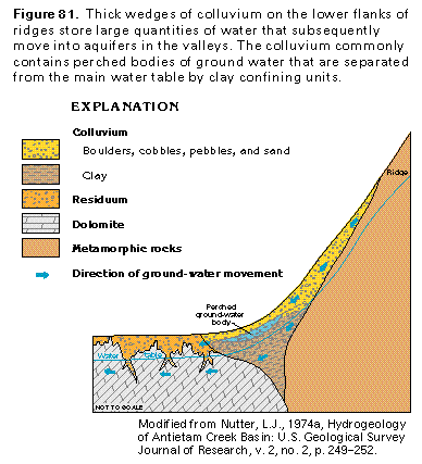
Circulating, slightly acidic ground water that moves along fractures and bedding planes in the carbonate rocks has partly dissolved these rocks in places and has created a network of large, interconnected openings that yield substantial quantities of water to wells. The alternating sequences of upfolded and downwarped rocks in the Valley and Ridge Province, coupled with the stream network that has developed in the folded rocks, create a series of shallow, isolated, local ground-water flow systems. Most of the ground water under the ridges flows across the strike of the rocks, but in the valleys, it usually moves along the strike. The flow within these local ground-water systems is predominately within a few hundred feet of the land surface, but circulation in some of the systems is deep enough for the water to become geothermally heated. The regolith that covers the consolidated rocks in most places has some primary porosity. The local flow systems receive recharge mostly to the regolith on the tops or flanks of ridges. The water then moves into the underlying bedrock or flows within the regolith downgradient toward the intervening valleys and discharges to streams or springs. Although the hard sandstone, conglomerate, and quartzite that typically cap the ridges have low permeability, the steep gradient provided by the dip of the beds and the relief usually is sufficient to move ground water into the adjoining valleys (fig. 81). Thick wedges of colluvium that locally cover the lower flanks of the ridges can temporarily store large quantities of water that later move into bedrock aquifers in the valleys. Perched water tables can over-lie local clayey zones in the colluvium and commonly are expressed by permanent to intermittent ponds. The perched water can be as much as 400 feet above the regional water table in the underlying consolidated rock.
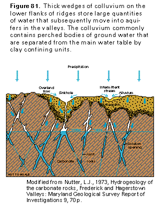
The carbonate rocks that are mostly in the valleys receive recharge from precipitation that falls directly on the valley floors (fig. 82), as well as from runoff from the adjacent ridges. Highly permeable solution zones that have developed by the enlargement of joints and other openings collect and channel the water. Sinkholes, which are closed depressions in the land surface that form where part of the roof of a solution cavity has collapsed, form a direct connection from the land surface to a carbonate aquifer. Surface runoff can move directly into a sinkhole, as can ground water in the regolith that overlies the carbonate rocks. Recharge to the aquifer through sinkholes takes place very quickly, and any contaminants at or near the land surface can move directly into the aquifer. Surface water that is channeled into small streams in the valleys can leak downward through the streambed to recharge the aquifer in places where the water table of the aquifer is lower than the water level in the stream.
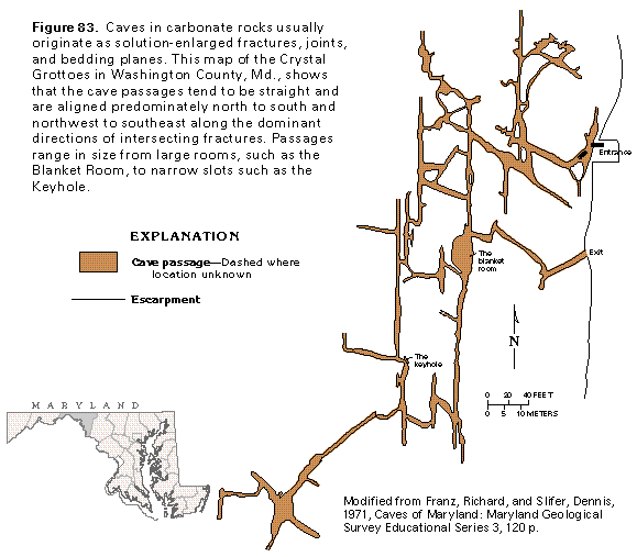
The flow paths of ground water in the Valley and Ridge Province are generally short, except for those in carbonate-rock aquifers where networks of solution openings prevail. Water can flow through connected solution conduits, such as those mapped in figure 83, for distances that range from thousands of feet to several miles. As it moves downgradient from recharge areas, the water tends to be concentrated in ever-larger conduits until it typically discharges as flow from a large spring. The larger solution channels, including caves, generally form at or near the water table, but some dissolution takes place as deep as 100 feet below the top of the zone of saturation. The orientation of the solution openings is parallel to that of the joints and fractures in the carbonate rocks. Secondary openings, such as joints in noncarbonate rocks, also have preferred orientations. As a result, wells completed in fractures or solution openings and wells completed in the intervening bedrock can have dissimilar heads and specific capacities, and the pumping of one well will have little effect on water levels in the other.
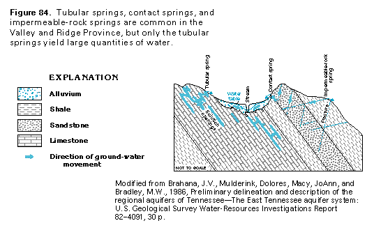
Although springs issue from some of the aquifers in all the physiographic provinces in Segment 11, large springs are most characteristic of the Valley and Ridge Province. Spring-flow is particularly large for springs that issue from the carbonate rocks. Three types of springs are common, and all result from ground-water movement driven by the force of gravity. Contact springs (fig. 84, center) form where water-saturated permeable material overlies less-permeable material. The water comes to the land surface at the contact of the two types of material, and the springs might issue where the contact intersects a sloping land surface. Contact springs are common in the Valley and Ridge Province but generally discharge only small volumes of water. Impermeable-rock springs (fig. 84, right) are fed by fractures, joints, or bedding planes in rocks that have low intergranular permeability. Small springs of this type that issue where a vertical joint intersects a bedding plane and that generally discharge only small volumes of water are typical of parts of the Appalachian Plateaus Province, but are also in the Valley and Ridge. Tubular springs (fig. 84, left) issue from solution channels in carbonate rocks. The largest magnitude springs are of this type because the catchment basins of networks of solution openings are likely to be more extensive than those of intersecting fractures, and the large solution openings in the carbonate rocks are able to transmit large quantities of water. For example, in Pennsylvania, 90 percent of the springs that discharge 100 gallons per minute or more issue from Ordovician and Cambrian limestones and dolomites; most of those that discharge more than 2,000 gallons per minute issue from limestone.
Water in the aquifers from which the springs issue can be either confined or unconfined. Springs that issue from aquifers that contain water under confined conditions are called artesian springs, whereas those that issue from unconfined aquifers are called gravity springs.
Spring location is related to geologic structure and topography. In the Valley and Ridge Province, many springs are located on or near anticlinal axes and around the noses of plunging anticlines. Open tension fractures tend to be concentrated in these places, and in the case of plunging anticlines, water-yielding beds may drain in the direction of plunge. Large springs are common where water gaps have been cut through anticlinal ridges because water-yielding geologic formations are commonly exposed at the lowest altitudes in these gaps. The bases of sandstone ridges are, in general, the sites of major springs. The largest springs tend to be in valleys, and some form the headwaters of streams.
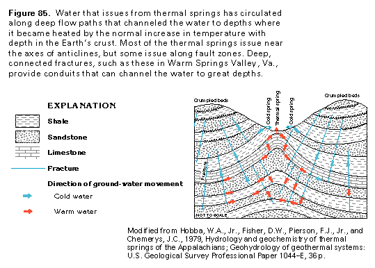
Some of the springs in the Valley and Ridge Province discharge water that is distinctly warmer than the average air temperature. Most of the thermal springs in the Eastern United States are in the Valley and Ridge Province. The spring waters have become naturally heated by deep circulation of the water to levels where the rocks are substantially warmer than the average surface temperature of the Earth. This increase in temperature with depth is called the geothermal gradient. The normal geothermal gradient for the Eastern United States is sufficient to warm the circulating water appreciably. For water to reach the temperatures observed in thermal springs of Segment 11, circulation to minimum depths of from 800 to 5,200 feet is required. Conditions for a thermal spring require that the flow of ground water be concentrated, channeled to depths sufficient to heat the water, and then channeled back to the land surface. Folding, faulting, and fracturing of confined aquifers provide the necessary paths and barriers to channel the flow of the water (fig. 85). Water enters fractured rocks at topographically high recharge areas, and the cold water moves deeply enough to become heated and subsequently rise. Thermal springs commonly issue in valleys that have developed on or near the crest of anticlines, but generally a variety of geologic structures combine to form the deep flow system that results in the thermal springs.
Deeply circulating waters might have a long residence time in the aquifer, and as the water is heated, it can become exposed to emanations of gases and vapors from deeper in the Earth. This exposure and the heat of the water facilitates the dissolution of minerals from the surrounding rock by the ground water. Generally, the water in thermal springs that discharge from limestone is mineralized and commonly contains hydrogen sulfide. The water from thermal springs that discharge from the Oriskany Sandstone is reported to contain more dissolved minerals than water from cold springs that issue from the same formation. Waters from many thermal springs have been thought to have medicinal properties because of the mineralization.
RELATION OF GEOLOGY AND WELL YIELD
Several geologic factors influence well yields in the Valley and Ridge Province. Some geologic structural factors affect the yield of wells completed in carbonate and noncar-bonate aquifers. Wells located along fracture traces in any type of rock usually yield much more water than wells that do not penetrate fractures. Fold hinges represent areas where fractures are more abundant and rock cleavage can be well developed, which enhances secondary permeability. Also, the dip of strata in the area of a fold hinge tends to be less, a factor associated with higher well yields. Wells completed in beds that dip at angles of less than 15 degrees generally yield more water than those completed in beds that are inclined more steeply because more bedding-plane partings are penetrated by a well of a given depth in the nearly horizontal strata than one of the same depth in steeply dipping beds. Wells located on anticlines yield more water than those on synclines because the fractures on anticlines are tensional and, thus, more apt to be open than the compressional fractures on synclines. Thin-bedded rocks generally have more closely spaced fractures than thick-bedded rocks and, therefore, are likely to have higher fracture permeability and to yield more water.
Topographic location affects well yield; wells in valley bottoms generally are more productive than those on ridges or uplands because fracture zones in noncarbonate rocks and solution channels in carbonate rocks tend to be concentrated in valleys. Regolith is generally thicker in valleys and, thus, stores more water for gradual release to the underlying bedrock aquifers.
Noncarbonate rocks interbedded with carbonate rocks are typically more permeable than noncarbonate rocks with no intervening carbonate strata. In noncarbonate rocks, friable sandstone probably is potentially the most productive aquifer. Shale, massive mudstone, and claystone are the least productive rock types.
Some factors influence well yields only in carbonate aquifers. Well yields are generally proportional to the thickness of the regolith that overlies a carbonate aquifer. The regolith acts as a sponge and stores water for gradual release to solution openings in the underlying carbonate rock. The continual release of this water contributes to the continued dissolution of the carbonate rock and expansion and enlargement of the solution openings. Well yield varies with carbonate rock type; the best- to worst-yielding carbonate lithologies are, in order, sandy dolomite, coarse-grained dolomite, limestone, and fine-grained dolomite.
GROUND-WATER QUALITY
The chemical quality of water in the aquifers of the Valley and Ridge Province is somewhat variable but is generally suitable for municipal supplies and other purposes. Most of the water in the upper parts of the aquifers is not greatly mineralized and is suitable for drinking and most other uses. However, the deep parts of the aquifers contain saline water in many places and brackish water has been reported locally from zones as shallow as 90 feet below the land surface in valleys near the West Branch of the Susquehanna River in Pennsylvania. The large dissolved-solids concentrations in the saline and brackish water might result from the dissolution of halite (rock salt) at greater depths by deeply-circulating water. Abandoned or improperly plugged boreholes drilled for oil and gas exploration provide paths for upward movement of mineralized water in some areas.
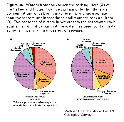
The carbonate-rock aquifers consist mainly of calcium and magnesium carbonate, which are readily dissolved and thus affect the chemical composition of ground water. Waters from these aquifers have dissolved-solids concentrations that average about 330 milligrams per liter and hardness that averages about 280 milligrams per liter, which is considered to be very hard. The median hydrogen ion concentration, which is measured in pH units, is 7.4 (slightly basic); dissolution of calcium and magnesium carbonate minerals raises the pH of the water and increases the hardness. The median iron concentration is 0.1 milligram per liter, which is considered to be low, but concentrations as large as 8 milligrams per liter have been reported. Water in the carbonate-rock aquifers is mostly a calcium plus magnesium bicarbonate type (fig. 86A).
The undifferentiated sedimentary-rock aquifers consist principally of fractured sandstone but locally include fractured shale. The minerals that compose these rocks are chiefly silicates, which are much less soluble than those that compose the carbonate-rock aquifers. The water is mostly a calcium bicarbonate type (fig. 86B). Dissolved-solids concentrations are small and average only about 150 milligrams per liter. Hardness averages about 100 milligrams per liter, and the water is considered to be moderately hard. The median hydrogen ion concentration, which is measured in pH units, is 7.4. The median iron concentration is about 0.1 milligram per liter, but concentrations as large as 14 milligrams per liter have been reported. In some coal-mining areas, the ground water is mixed with acidic mine water, which can contain large concentrations of iron, manganese, sulfate, and dissolved solids.
FRESH GROUND-WATER WITHDRAWALS
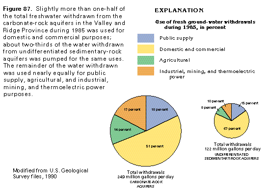
Total freshwater withdrawals from consolidated-rock aquifers in the Valley and Ridge Province in Segment 11 were about 371 million gallons per day during 1985. With-drawals from carbonate-rock aquifers were estimated to be 249 million gallons per day (fig. 87). Slightly more than one-half of this water was used for domestic and commercial supplies. Withdrawals from undifferentiated sedimentary-rock aquifers, primarily sandstone aquifers, in the Valley and Ridge Province were estimated to be 122 million gallons per day. About two-thirds of this water was used for domestic and commercial supplies.