GROUND WATER ATLAS of the UNITED STATES
Connecticut, Maine, Massachusetts, New Hampshire, New York, Rhode Island,
Vermont
HA 730-M
Sandstone aquifers
There are two different files for each illustration
- A 72 ppi GIF file, suitable for screen viewing is accessed through
the thumbnail image
- An eps file, suitable for downloading to be printed or edited is accessed
through the "eps file" link. Most files are Adobe Illustrator
6.0, exceptions are noted. These files have been compressed with GNU's
gzip utility. If your web browser defaults to a screen display of the file,
turn on the "Load to local disk" option before downloading. Download
and process these eps files as ascii, not binary.
Geology
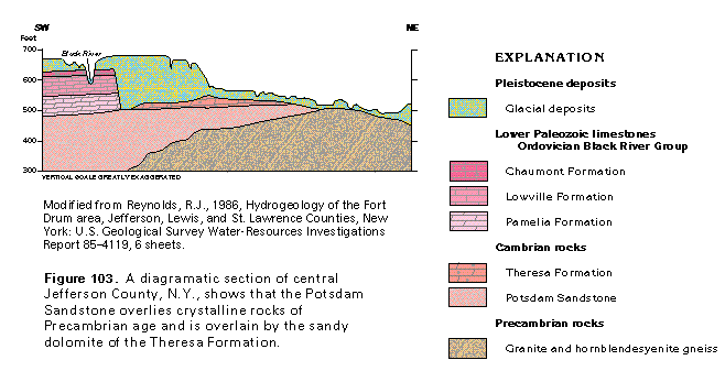
Figure 103 Diagramatic section of central Jefferson County, N.Y.
(17K)
 editable eps file M103.eps.gz
(132K compressed)
editable eps file M103.eps.gz
(132K compressed)
Figure 104 Cross section (17K)
 editable eps file M104.eps.gz
(33K compressed)
editable eps file M104.eps.gz
(33K compressed)
Figure 105 Photo showing continental deposits of reddish
arkosic sandstone (66K)
 This illustration contains a placed image. Download the Adobe Illustrator
6 eps file M105.eps.gz (7.8M compressed)
which contains an imbedded Adobe Photoshop 3 (eps) file. You may also want
to download the editable Photoshop
file M105psh.eps.gz (7.8M compressed)
This illustration contains a placed image. Download the Adobe Illustrator
6 eps file M105.eps.gz (7.8M compressed)
which contains an imbedded Adobe Photoshop 3 (eps) file. You may also want
to download the editable Photoshop
file M105psh.eps.gz (7.8M compressed)
Figure 106 Map showing rock types (33K)
 editable eps file M106.eps.gz
(83K compressed)
editable eps file M106.eps.gz
(83K compressed)
 editable eps file M103.eps.gz
(132K compressed)
editable eps file M103.eps.gz
(132K compressed)  editable eps file M104.eps.gz
(33K compressed)
editable eps file M104.eps.gz
(33K compressed) 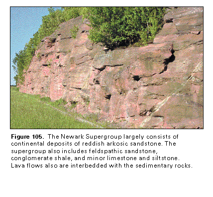 This illustration contains a placed image. Download the Adobe Illustrator
6 eps file M105.eps.gz (7.8M compressed)
which contains an imbedded Adobe Photoshop 3 (eps) file. You may also want
to download the editable Photoshop
file M105psh.eps.gz (7.8M compressed)
This illustration contains a placed image. Download the Adobe Illustrator
6 eps file M105.eps.gz (7.8M compressed)
which contains an imbedded Adobe Photoshop 3 (eps) file. You may also want
to download the editable Photoshop
file M105psh.eps.gz (7.8M compressed) 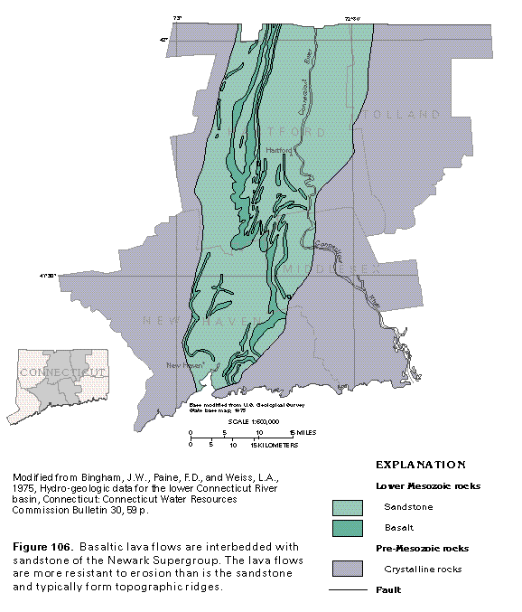 editable eps file M106.eps.gz
(83K compressed)
editable eps file M106.eps.gz
(83K compressed)