GROUND WATER ATLAS of the UNITED STATES
Connecticut, Maine, Massachusetts, New Hampshire, New York, Rhode Island,
Vermont
HA 730-M
Carbonate-rock aquifers
There are two different files for each illustration
- A 72 ppi GIF file, suitable for screen viewing is accessed through
the thumbnail image
- An eps file, suitable for downloading to be printed or edited is accessed
through the "eps file" link. Most files are Adobe Illustrator
6.0, exceptions are noted. These files have been compressed with GNU's
gzip utility. If your web browser defaults to a screen display of the file,
turn on the "Load to local disk" option before downloading. Download
and process these eps files as ascii, not binary.
Geology
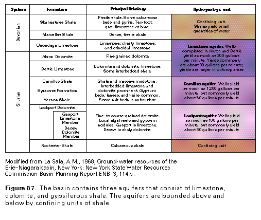
Figure 87 Correlation chart (17K)
 editable eps file M087.eps.gz
(17K compressed)
editable eps file M087.eps.gz
(17K compressed)
Figure 88 Geologic cross section (17K)
 editable eps file M088.eps.gz
(33K compressed)
editable eps file M088.eps.gz
(33K compressed)
Figure 89 Chart showing depth to different rock types
(17K)
 editable eps file M089.eps.gz
(33K compressed)
editable eps file M089.eps.gz
(33K compressed)
 editable eps file M087.eps.gz
(17K compressed)
editable eps file M087.eps.gz
(17K compressed) 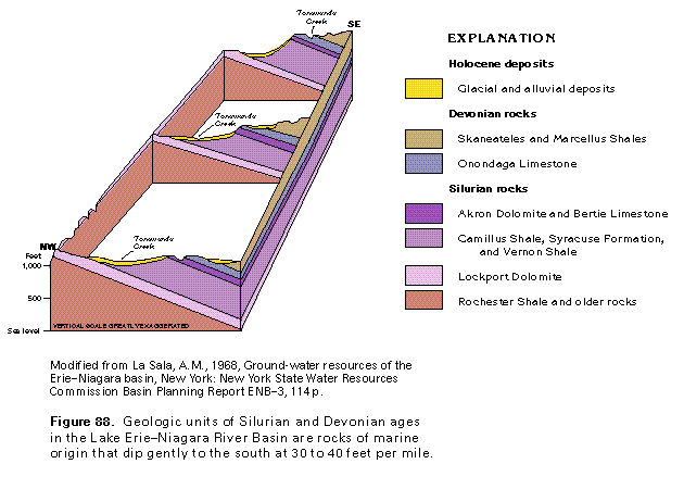 editable eps file M088.eps.gz
(33K compressed)
editable eps file M088.eps.gz
(33K compressed)