GROUND WATER ATLAS of the UNITED STATES
Connecticut, Maine, Massachusetts, New Hampshire, New York, Rhode Island,
Vermont
HA 730-M
Carbonate-rock aquifers
There are two different files for each illustration
- A 72 ppi GIF file, suitable for screen viewing is accessed through
the thumbnail image
- An eps file, suitable for downloading to be printed or edited is accessed
through the "eps file" link. Most files are Adobe Illustrator
6.0, exceptions are noted. These files have been compressed with GNU's
gzip utility. If your web browser defaults to a screen display of the file,
turn on the "Load to local disk" option before downloading. Download
and process these eps files as ascii, not binary.
Aquifers and their characteristics
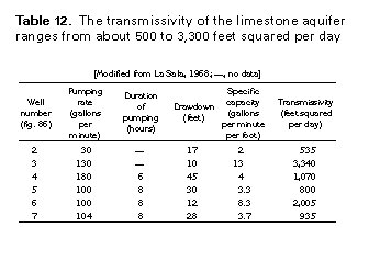
Table 12 Table listing transmissivity of the Limestone aquifer (17K)
 editable eps file Mtab12.eps.gz
(17K compressed)
editable eps file Mtab12.eps.gz
(17K compressed)
Table 13 Table listing transmissivity of the Camillus
aquifer (17K)
 editable eps file Mtab13.eps.gz
(17K compressed)
editable eps file Mtab13.eps.gz
(17K compressed)
Figure 90 Photo showing outcrop of the Lockport aquifer
(50K)
 This illustration contains a placed image. Download the Adobe Illustrator
6 eps file M090.eps.gz (7.3M compressed)
which contains an imbedded Adobe Photoshop 3 (eps) file. You may also want
to download the editable Photoshop
file M090psh.eps.gz (7.2M compressed)
This illustration contains a placed image. Download the Adobe Illustrator
6 eps file M090.eps.gz (7.3M compressed)
which contains an imbedded Adobe Photoshop 3 (eps) file. You may also want
to download the editable Photoshop
file M090psh.eps.gz (7.2M compressed)
Figure 91 Chart showing depth to the Lockport dolomite
(17K)
 editable eps file M091.eps.gz
(33K compressed)
editable eps file M091.eps.gz
(33K compressed)
 editable eps file Mtab12.eps.gz
(17K compressed)
editable eps file Mtab12.eps.gz
(17K compressed) 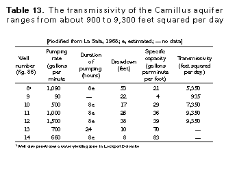 editable eps file Mtab13.eps.gz
(17K compressed)
editable eps file Mtab13.eps.gz
(17K compressed)  This illustration contains a placed image. Download the Adobe Illustrator
6 eps file M090.eps.gz (7.3M compressed)
which contains an imbedded Adobe Photoshop 3 (eps) file. You may also want
to download the editable Photoshop
file M090psh.eps.gz (7.2M compressed)
This illustration contains a placed image. Download the Adobe Illustrator
6 eps file M090.eps.gz (7.3M compressed)
which contains an imbedded Adobe Photoshop 3 (eps) file. You may also want
to download the editable Photoshop
file M090psh.eps.gz (7.2M compressed)