GROUND WATER ATLAS of the UNITED STATES
Connecticut, Maine, Massachusetts, New Hampshire, New York, Rhode Island,
Vermont
HA 730-M
Carbonate-rock aquifers
There are two different files for each illustration
- A 72 ppi GIF file, suitable for screen viewing is accessed through
the thumbnail image
- An eps file, suitable for downloading to be printed or edited is accessed
through the "eps file" link. Most files are Adobe Illustrator
6.0, exceptions are noted. These files have been compressed with GNU's
gzip utility. If your web browser defaults to a screen display of the file,
turn on the "Load to local disk" option before downloading. Download
and process these eps files as ascii, not binary.
Ground-water quality
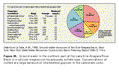
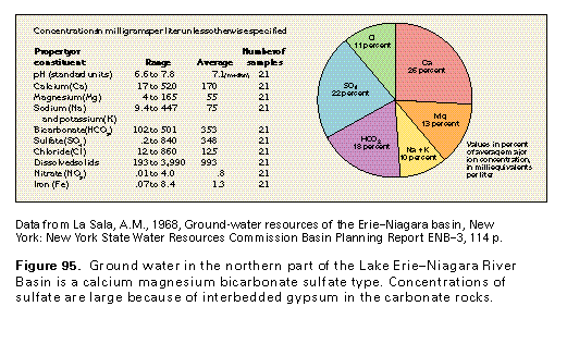
Figure 95 Chart and table showing chemical concentrations of the
Lake Erie-Niagara River Basin (17K)
 editable eps file M095.eps.gz
(17K compressed)
editable eps file M095.eps.gz
(17K compressed)
Figure 96 Map showing sulfate concentration (33K)
 editable eps file M096.eps.gz
(50K compressed)
editable eps file M096.eps.gz
(50K compressed)
Figure 97 Map showing chloride concentration (17K)
 editable eps file M097.eps.gz
(50K compressed)
editable eps file M097.eps.gz
(50K compressed)
Figure 98 Map showing hardness as calcium carbonate
(33K)
 editable eps file M098.eps.gz
(50K compressed)
editable eps file M098.eps.gz
(50K compressed)
 editable eps file M095.eps.gz
(17K compressed)
editable eps file M095.eps.gz
(17K compressed) 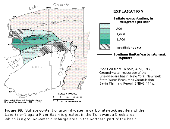 editable eps file M096.eps.gz
(50K compressed)
editable eps file M096.eps.gz
(50K compressed) 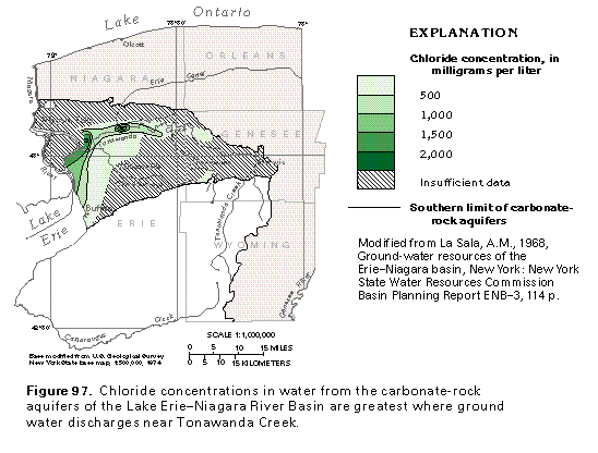 editable eps file M097.eps.gz
(50K compressed)
editable eps file M097.eps.gz
(50K compressed) 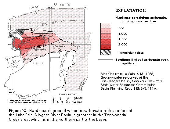 editable eps file M098.eps.gz
(50K compressed)
editable eps file M098.eps.gz
(50K compressed)