GROUND WATER ATLAS of the UNITED STATES
Connecticut, Maine, Massachusetts, New Hampshire, New York, Rhode Island,
Vermont
HA 730-M
Surficial and Northern Atlantic Coastal Plain aquifer systems, Long Island
There are two different files for each illustration
- A 72 ppi GIF file, suitable for screen viewing is accessed through
the thumbnail image
- An eps file, suitable for downloading to be printed or edited is accessed
through the "eps file" link. Most files are Adobe Illustrator
6.0, exceptions are noted. These files have been compressed with GNU's
gzip utility. If your web browser defaults to a screen display of the file,
turn on the "Load to local disk" option before downloading. Download
and process these eps files as ascii, not binary.
Hydrogeology
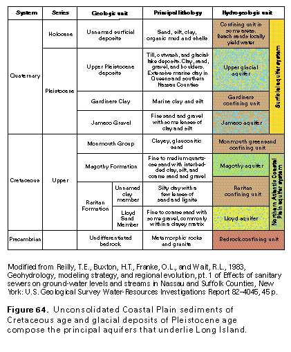
Figure 64 Correlation chart (33K)
 editable eps file M064.eps.gz
(66K compressed)
editable eps file M064.eps.gz
(66K compressed)
Figure 65 Map showing structure contours (33K)
 editable eps file M065.eps.gz
(132K compressed)
editable eps file M065.eps.gz
(132K compressed)
Figure 66 Photo showing crystalline bedrock (50K)
 This illustration contains a placed image. Download the Adobe Illustrator
6 eps file M066.eps.gz (6.9M compressed)
which contains an imbedded Adobe Photoshop 3 (eps) file. You may also want
to download the editable Photoshop
file M066psh.eps.gz (6.9M compressed)
This illustration contains a placed image. Download the Adobe Illustrator
6 eps file M066.eps.gz (6.9M compressed)
which contains an imbedded Adobe Photoshop 3 (eps) file. You may also want
to download the editable Photoshop
file M066psh.eps.gz (6.9M compressed)
Figure 67 Map showing thickness of the Lloyd aquifer
(33K)
 editable eps file M067.eps.gz
(149K compressed)
editable eps file M067.eps.gz
(149K compressed)
Figure 68 Map showing thickness of the Magothy aquifer (33K)
 editable eps file M068.eps.gz
(165K compressed)
editable eps file M068.eps.gz
(165K compressed)
Figure 69 Map showing thickness of the Monmouth greensand
and the Jameco Gravel (33K)
 editable eps file M069.eps.gz
(149K compressed)
editable eps file M069.eps.gz
(149K compressed)
Figure 70 Hydrogeologic section (17K)
 editable eps file M070.eps.gz
(50K compressed)
editable eps file M070.eps.gz
(50K compressed)
Figure 71 Hydrogeologic section (17K)
 editable eps file M071.eps.gz
(33K compressed)
editable eps file M071.eps.gz
(33K compressed)
 editable eps file M064.eps.gz
(66K compressed)
editable eps file M064.eps.gz
(66K compressed) 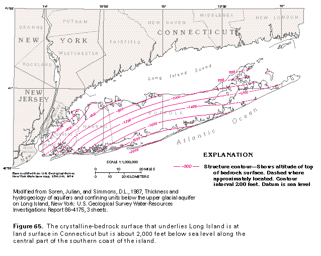 editable eps file M065.eps.gz
(132K compressed)
editable eps file M065.eps.gz
(132K compressed) 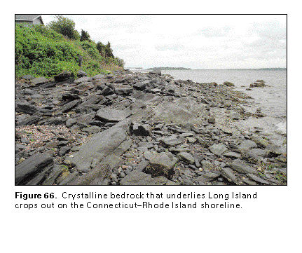 This illustration contains a placed image. Download the Adobe Illustrator
6 eps file M066.eps.gz (6.9M compressed)
which contains an imbedded Adobe Photoshop 3 (eps) file. You may also want
to download the editable Photoshop
file M066psh.eps.gz (6.9M compressed)
This illustration contains a placed image. Download the Adobe Illustrator
6 eps file M066.eps.gz (6.9M compressed)
which contains an imbedded Adobe Photoshop 3 (eps) file. You may also want
to download the editable Photoshop
file M066psh.eps.gz (6.9M compressed) 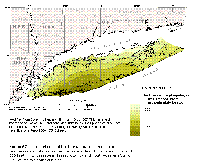 editable eps file M067.eps.gz
(149K compressed)
editable eps file M067.eps.gz
(149K compressed) 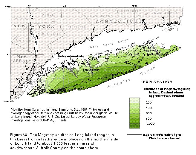 editable eps file M068.eps.gz
(165K compressed)
editable eps file M068.eps.gz
(165K compressed) 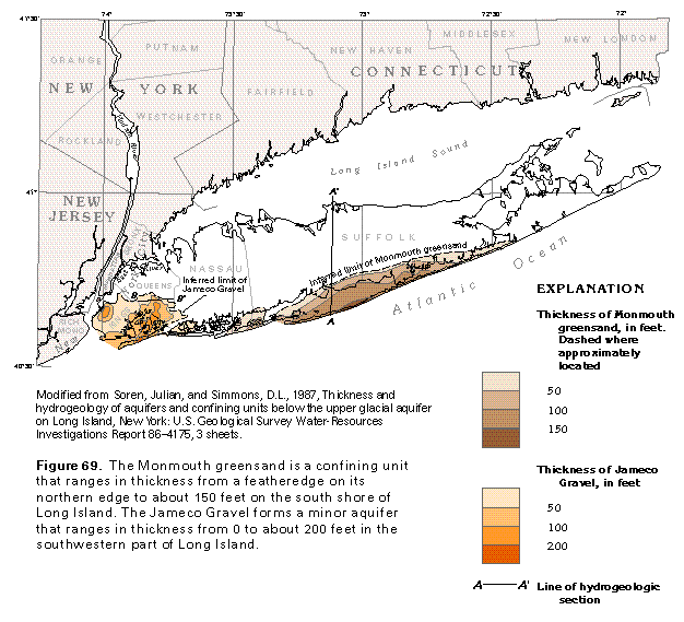 editable eps file M069.eps.gz
(149K compressed)
editable eps file M069.eps.gz
(149K compressed) 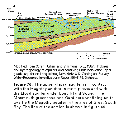 editable eps file M070.eps.gz
(50K compressed)
editable eps file M070.eps.gz
(50K compressed) 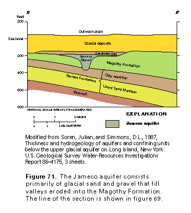 editable eps file M071.eps.gz
(33K compressed)
editable eps file M071.eps.gz
(33K compressed)