GROUND WATER ATLAS of the UNITED STATES
Connecticut, Maine, Massachusetts, New Hampshire, New York, Rhode Island,
Vermont
HA 730-M
Surficial and Northern Atlantic Coastal Plain aquifer systems, Long Island
There are two different files for each illustration
- A 72 ppi GIF file, suitable for screen viewing is accessed through
the thumbnail image
- An eps file, suitable for downloading to be printed or edited is accessed
through the "eps file" link. Most files are Adobe Illustrator
6.0, exceptions are noted. These files have been compressed with GNU's
gzip utility. If your web browser defaults to a screen display of the file,
turn on the "Load to local disk" option before downloading. Download
and process these eps files as ascii, not binary.
Ground-water flow
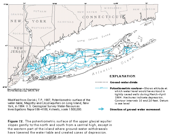
Figure 72 Potentiometric contour map of the upper glacial aquifer
(33K)
 editable eps file M072.eps.gz
(149K compressed)
editable eps file M072.eps.gz
(149K compressed)
Figure 73 Potentiometric contour map of the Magothy aquifer
(33K)
 editable eps file M073.eps.gz
(149K compressed)
editable eps file M073.eps.gz
(149K compressed)
Figure 74 Potentiometric contour map of the Lloyd aquifer
(33K)
 editable eps file M074.eps.gz
(149K compressed)
editable eps file M074.eps.gz
(149K compressed)
Table 10 Table showing hydraulic conductivity (33K)
 editable eps file Mtab10.eps.gz
(17K compressed)
editable eps file Mtab10.eps.gz
(17K compressed)
Figure 75 Potentiometric contour map of the upper glacial
aquifer (33K)
 editable eps file M075.eps.gz
(149K compressed)
editable eps file M075.eps.gz
(149K compressed)
Figure 76 Hydrogeologic section (17K)
 editable eps file M076.eps.gz
(66K compressed)
editable eps file M076.eps.gz
(66K compressed)
Figure 77 Hydrogeologic section (17K)
 editable eps file M077.eps.gz
(50K compressed)
editable eps file M077.eps.gz
(50K compressed)
Figure 78 Hydrogeologic section (17K)
 This illustration contains a placed image. Download the Adobe Illustrator
6 eps file M078.eps.gz (50K compressed)
which contains an imbedded Adobe Photoshop 3 (eps) file. You may also want
to download the editable Photoshop
file M078psh.eps.gz (17K compressed)
This illustration contains a placed image. Download the Adobe Illustrator
6 eps file M078.eps.gz (50K compressed)
which contains an imbedded Adobe Photoshop 3 (eps) file. You may also want
to download the editable Photoshop
file M078psh.eps.gz (17K compressed)
Figure 79 Hydrogeologic section (17K)
 editable eps file M079.eps.gz
(66K compressed)
editable eps file M079.eps.gz
(66K compressed)
Figure 80 Hydrogeologic section (33K)
 editable eps file M080.eps.gz
(50K compressed)
editable eps file M080.eps.gz
(50K compressed)
Figure 81 Map showing area used in estimating rates
of water movement (17K)
 editable eps file M081.eps.gz
(50K compressed)
editable eps file M081.eps.gz
(50K compressed)
Table 11 Table listing rates of movement (17K)
 editable eps file Mtab11.eps.gz
(17K compressed)
editable eps file Mtab11.eps.gz
(17K compressed)
 editable eps file M072.eps.gz
(149K compressed)
editable eps file M072.eps.gz
(149K compressed) 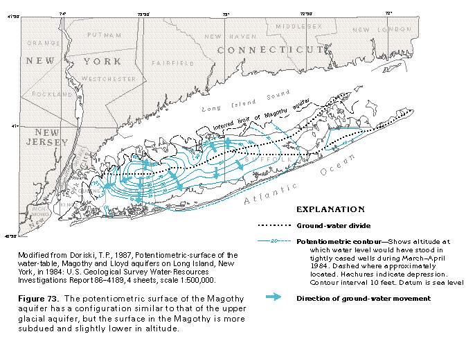 editable eps file M073.eps.gz
(149K compressed)
editable eps file M073.eps.gz
(149K compressed) 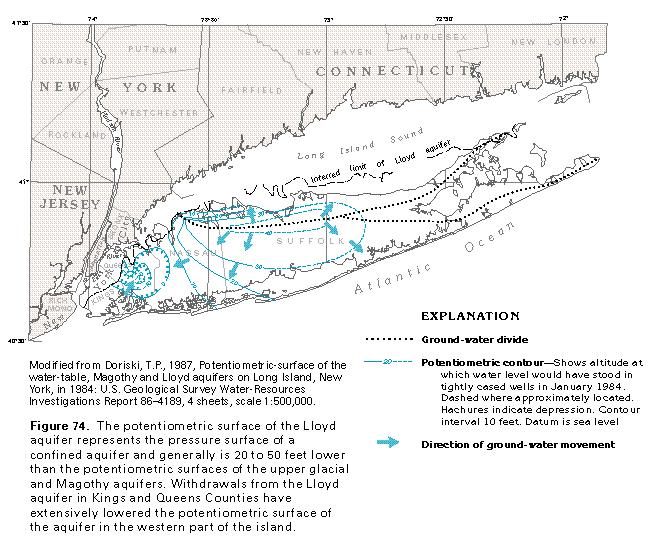 editable eps file M074.eps.gz
(149K compressed)
editable eps file M074.eps.gz
(149K compressed) 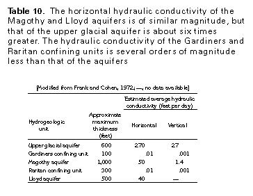 editable eps file Mtab10.eps.gz
(17K compressed)
editable eps file Mtab10.eps.gz
(17K compressed) 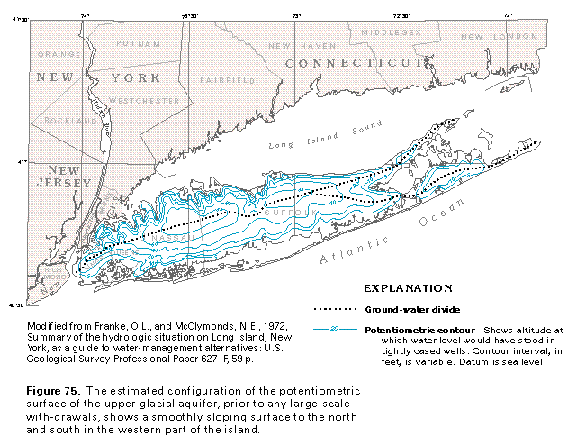 editable eps file M075.eps.gz
(149K compressed)
editable eps file M075.eps.gz
(149K compressed) 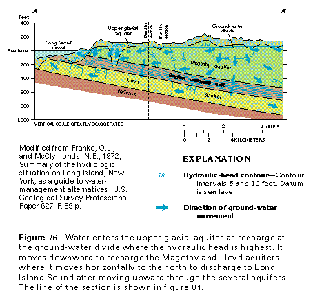 editable eps file M076.eps.gz
(66K compressed)
editable eps file M076.eps.gz
(66K compressed) 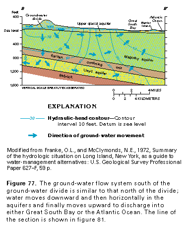 editable eps file M077.eps.gz
(50K compressed)
editable eps file M077.eps.gz
(50K compressed) 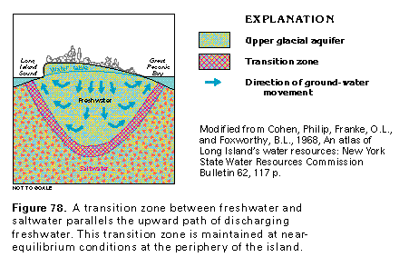 This illustration contains a placed image. Download the Adobe Illustrator
6 eps file M078.eps.gz (50K compressed)
which contains an imbedded Adobe Photoshop 3 (eps) file. You may also want
to download the editable Photoshop
file M078psh.eps.gz (17K compressed)
This illustration contains a placed image. Download the Adobe Illustrator
6 eps file M078.eps.gz (50K compressed)
which contains an imbedded Adobe Photoshop 3 (eps) file. You may also want
to download the editable Photoshop
file M078psh.eps.gz (17K compressed) 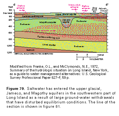 editable eps file M079.eps.gz
(66K compressed)
editable eps file M079.eps.gz
(66K compressed) 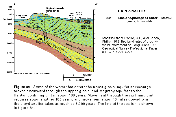 editable eps file M080.eps.gz
(50K compressed)
editable eps file M080.eps.gz
(50K compressed) 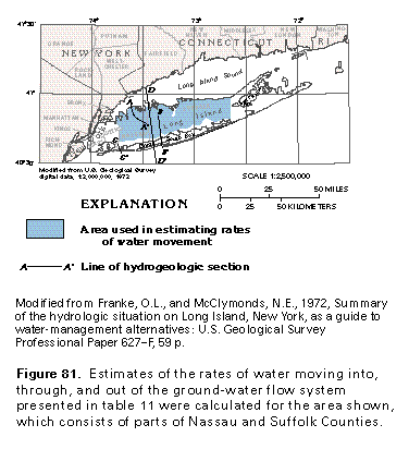 editable eps file M081.eps.gz
(50K compressed)
editable eps file M081.eps.gz
(50K compressed) 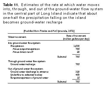 editable eps file Mtab11.eps.gz
(17K compressed)
editable eps file Mtab11.eps.gz
(17K compressed)