GROUND WATER ATLAS of the UNITED STATES
Connecticut, Maine, Massachusetts, New Hampshire, New York, Rhode Island,
Vermont
HA 730-M
Surficial aquifer system, Cape Cod glacial aquifer
There are two different files for each illustration
- A 72 ppi GIF file, suitable for screen viewing is accessed through
the thumbnail image
- An eps file, suitable for downloading to be printed or edited is accessed
through the "eps file" link. Most files are Adobe Illustrator
6.0, exceptions are noted. These files have been compressed with GNU's
gzip utility. If your web browser defaults to a screen display of the file,
turn on the "Load to local disk" option before downloading. Download
and process these eps files as ascii, not binary.
Hydrology
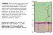
Figure 55 Map showing water-table contours and gound-water discharge
(33K)
 editable eps file M055.eps.gz
(99K compressed)
editable eps file M055.eps.gz
(99K compressed)
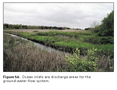
Figure 56 Photo showing an ocean inlet (50K)
 This illustration contains a placed image. Download the Adobe Illustrator
6 eps file M056.eps.gz (7.0M compressed)
which contains an imbedded Adobe Photoshop 3 (eps) file. You may also want
to download the editable Photoshop
file M056psh.eps.gz (7.0M compressed)
This illustration contains a placed image. Download the Adobe Illustrator
6 eps file M056.eps.gz (7.0M compressed)
which contains an imbedded Adobe Photoshop 3 (eps) file. You may also want
to download the editable Photoshop
file M056psh.eps.gz (7.0M compressed)
Figure 57 Cross section (17K)
 editable eps file M057.eps.gz
(33K compressed)
editable eps file M057.eps.gz
(33K compressed)
Figure 58 Well log for well MIW26 (33K)
 editable eps file M058.eps.gz
(33K compressed)
editable eps file M058.eps.gz
(33K compressed)
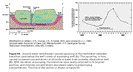
Figure 59 Cross section and graph of chloride concentration
(33K)
 editable eps file M059.eps.gz
(50K compressed)
editable eps file M059.eps.gz
(50K compressed)
 This illustration contains a placed image. Download the Adobe Illustrator
6 eps file M056.eps.gz (7.0M compressed)
which contains an imbedded Adobe Photoshop 3 (eps) file. You may also want
to download the editable Photoshop
file M056psh.eps.gz (7.0M compressed)
This illustration contains a placed image. Download the Adobe Illustrator
6 eps file M056.eps.gz (7.0M compressed)
which contains an imbedded Adobe Photoshop 3 (eps) file. You may also want
to download the editable Photoshop
file M056psh.eps.gz (7.0M compressed) 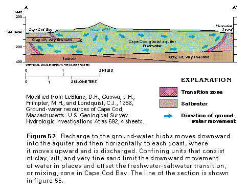 editable eps file M057.eps.gz
(33K compressed)
editable eps file M057.eps.gz
(33K compressed) 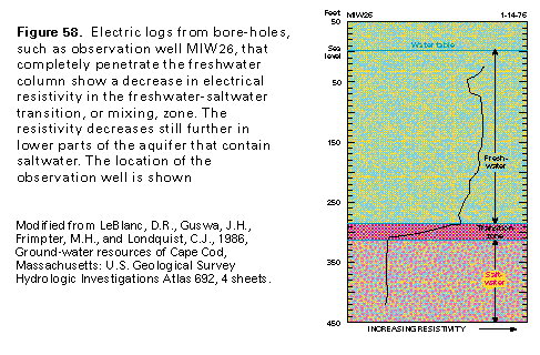 editable eps file M058.eps.gz
(33K compressed)
editable eps file M058.eps.gz
(33K compressed) 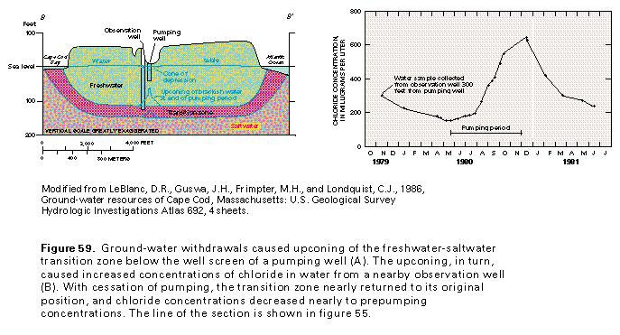 editable eps file M059.eps.gz
(50K compressed)
editable eps file M059.eps.gz
(50K compressed)