GROUND WATER ATLAS of the UNITED STATES
Connecticut, Maine, Massachusetts, New Hampshire, New York, Rhode Island,
Vermont
HA 730-M
Surficial aquifer system, Valley-fill glacial aquifers
There are two different files for each illustration
- A 72 ppi GIF file, suitable for screen viewing is accessed through
the thumbnail image
- An eps file, suitable for downloading to be printed or edited is accessed
through the "eps file" link. Most files are Adobe Illustrator
6.0, exceptions are noted. These files have been compressed with GNU's
gzip utility. If your web browser defaults to a screen display of the file,
turn on the "Load to local disk" option before downloading. Download
and process these eps files as ascii, not binary.
Hydrology
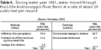
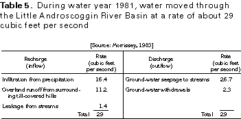
Table 5 Table listing recharge and discharge rates (17K)
 editable eps file Mtab5.eps.gz
(17K compressed)
editable eps file Mtab5.eps.gz
(17K compressed)
Table 6 Table listing estimated hydraulic conductivity
for glacial material (17K)
 editable eps file Mtab6.eps.gz
(17K compressed)
editable eps file Mtab6.eps.gz
(17K compressed)
Figure 38 Map showing water-table contour (33K)
 editable eps file M038.eps.gz
(83K compressed)
editable eps file M038.eps.gz
(83K compressed)
Figure 39 Hydrogeologic section of aquifer (17K)
 editable eps file M039.eps.gz
(33K compressed)
editable eps file M039.eps.gz
(33K compressed)
Figure 40 Photo showing marine sediments (33K)
 This illustration contains a placed image. Download the Adobe Illustrator
6 eps file M040.eps.gz (5.1M compressed)
which contains an imbedded Adobe Photoshop 3 (eps) file. You may also want
to download the editable Photoshop
file M040psh.eps.gz (5.1M compressed)
This illustration contains a placed image. Download the Adobe Illustrator
6 eps file M040.eps.gz (5.1M compressed)
which contains an imbedded Adobe Photoshop 3 (eps) file. You may also want
to download the editable Photoshop
file M040psh.eps.gz (5.1M compressed)
 editable eps file Mtab5.eps.gz
(17K compressed)
editable eps file Mtab5.eps.gz
(17K compressed) 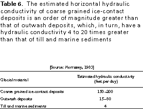 editable eps file Mtab6.eps.gz
(17K compressed)
editable eps file Mtab6.eps.gz
(17K compressed) 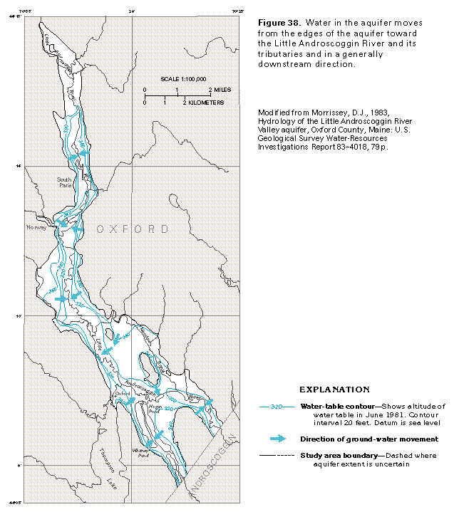 editable eps file M038.eps.gz
(83K compressed)
editable eps file M038.eps.gz
(83K compressed) 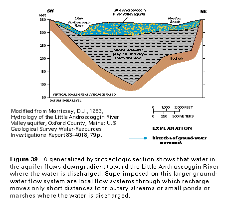 editable eps file M039.eps.gz
(33K compressed)
editable eps file M039.eps.gz
(33K compressed) 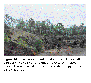 This illustration contains a placed image. Download the Adobe Illustrator
6 eps file M040.eps.gz (5.1M compressed)
which contains an imbedded Adobe Photoshop 3 (eps) file. You may also want
to download the editable Photoshop
file M040psh.eps.gz (5.1M compressed)
This illustration contains a placed image. Download the Adobe Illustrator
6 eps file M040.eps.gz (5.1M compressed)
which contains an imbedded Adobe Photoshop 3 (eps) file. You may also want
to download the editable Photoshop
file M040psh.eps.gz (5.1M compressed)