INTRODUCTION
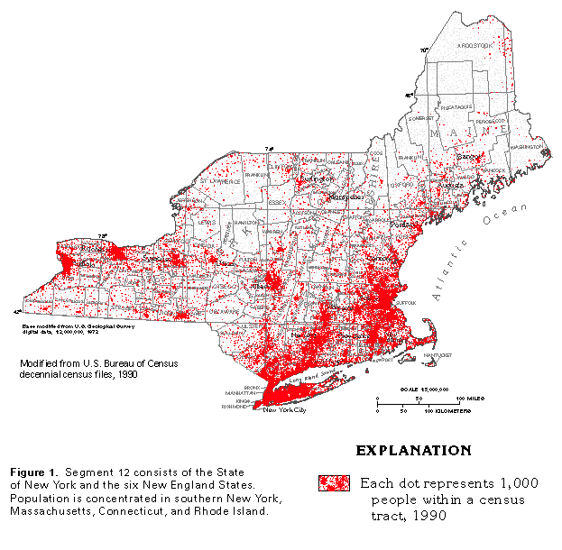
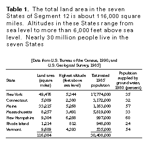
The State of New York and the six New England States of Maine, Vermont, New Hampshire, Massachusetts, Connecticut, and Rhode Island compose Segment 12 of this Atlas (fig. 1). The seven States have a total land area of about 116,000 square miles (table 1); all but a small area in southwestern New York has been glaciated.
Population in the States of Segment 12 totals about 30,408,000 (table 1) and is concentrated in southern and eastern Massachusetts, Connecticut, Rhode Island, and especially New York (fig. 1). The northern part of the segment and the mountainous areas of New York and much of New Hampshire, Vermont, and Maine are sparsely populated.
The percentage of population supplied from ground-water sources during 1980 was 54 to 60 percent in Maine, New Hampshire, and Vermont (table 1). Nearly all rural, domestic, and small-community water systems obtain water from wells that are, in comparison with other sources, the safest and the least expensive to install and maintain. Where water demand is great-in the urban areas of New York, Connecticut, Massachusetts, and Rhode Island-sophisticated reservoir, pipeline, and purification systems are economically feasible and are needed to meet demands. Surface water is the principal source of supply in these four States, and ground water was used to supply only 24 to 35 percent of their population during 1980 (table 1).
PHYSIOGRAPHY
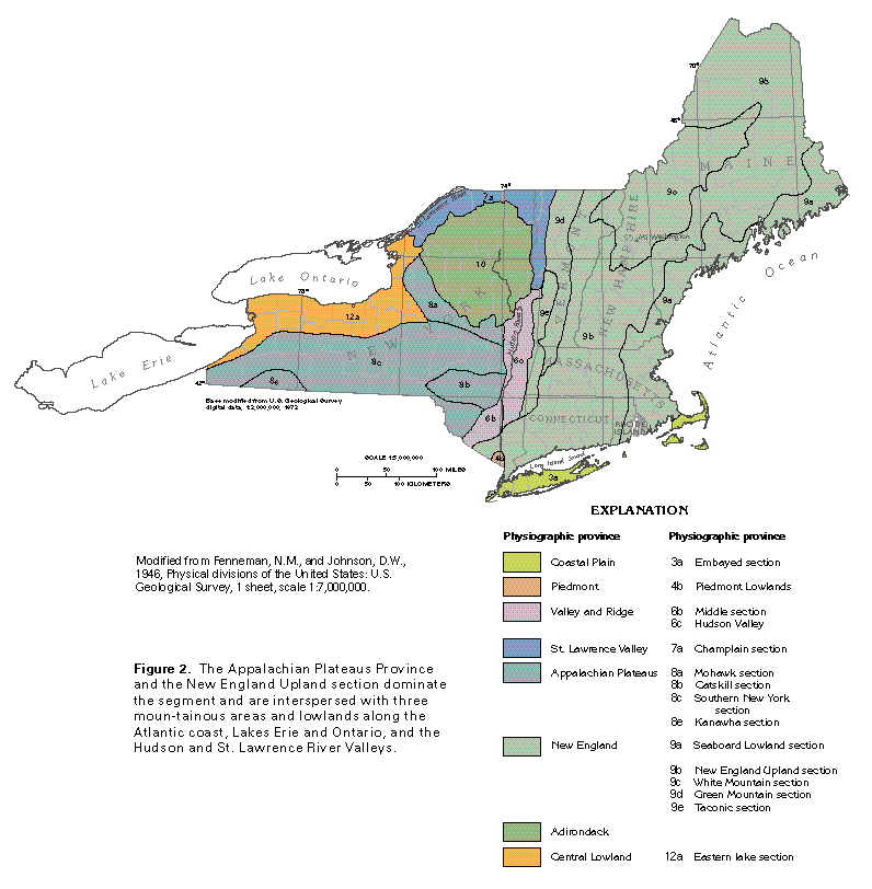
The States in Segment 12 incorporate a variety of topographic features that range in altitude from more than 6,200 feet above sea level at Mount Washington in New Hampshire (table 1) to sea level along the Atlantic seaboard. The land of these States has been subdivided into physiographic provinces and sections (fig. 2) that range from mountainous areas, such as the White Mountains of New Hampshire and Maine, the Taconic and Green Mountains of New York, Massachusetts, and Vermont, and the Adirondack Mountains of New York, to lowland areas, such as the Central Lowland along Lakes Erie and Ontario and the Coastal Plain and Seaboard Lowland along the Atlantic coast. The Appalachian Plateaus and the New England Upland, which are of intermediate altitude between mountains and lowlands, dominate Segment 12 and extend from western New York through much of central New England.
The bedrock surface in the States of Segment 12 was deeply dissected by erosion before and during glaciation. A cover of glacial debris, however, moderates the relief of this erosional surface, resulting in rolling to flat topography in the lowland areas and flat-bottomed, partially filled valleys between highlands in the plateaus, uplands, and mountainous areas.
PRECIPITATION AND RUNOFF
Precipitation is the source of all freshwater in the seven States of Segment 12. Most of the precipitation runs directly off the land surface to streams or reaches streams after temporary storage in lakes, reservoirs, wetlands, soils, and aquifers. Water that leaves the area on its way to the ocean as streamflow is called surface runoff. Much of the remainder is returned to the atmosphere by evapotranspiration (evaporation from lakes, marshes, and other surface-water bodies coupled with transpiration from plants). A small part of the precipitation infiltrates the land surface and percolates downward to recharge aquifers.
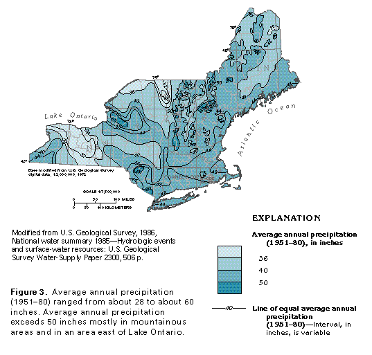
Average annual precipitation in the seven-State area ranged from about 28 to about 60 inches from 1951 through 1980 (fig. 3). Precipitation was least (36 inches or less) in parts of New York, Vermont, and Maine. The greatest precipitation (50 to about 60 inches) fell in the mountainous areas of New York, Vermont, New Hampshire, Massachusetts, and Maine because of the orographic effect of the mountains, and in an area east of Lake Ontario, because of the effect of the lake. Average annual precipitation was greater than 40 inches in about two-thirds of Segment 12.
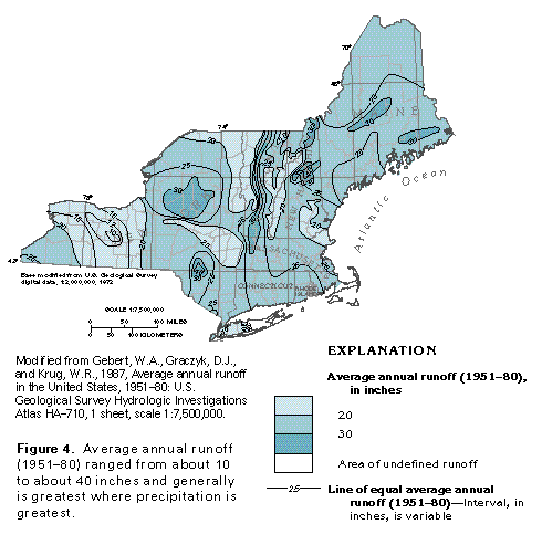
Average annual runoff from 1951 through 1980 ranged from about 10 to about 40 inches (fig. 4); however, runoff from much of the area from western New York to Maine was in the 20- to 30-inch range. Generally, the quantity of runoff is directly related to the quantity of precipitation throughout the seven-State area. Precipitation is about two times greater than runoff in most parts of the seven-State area (compare fig. 3 with fig. 4).
GEOLOGY
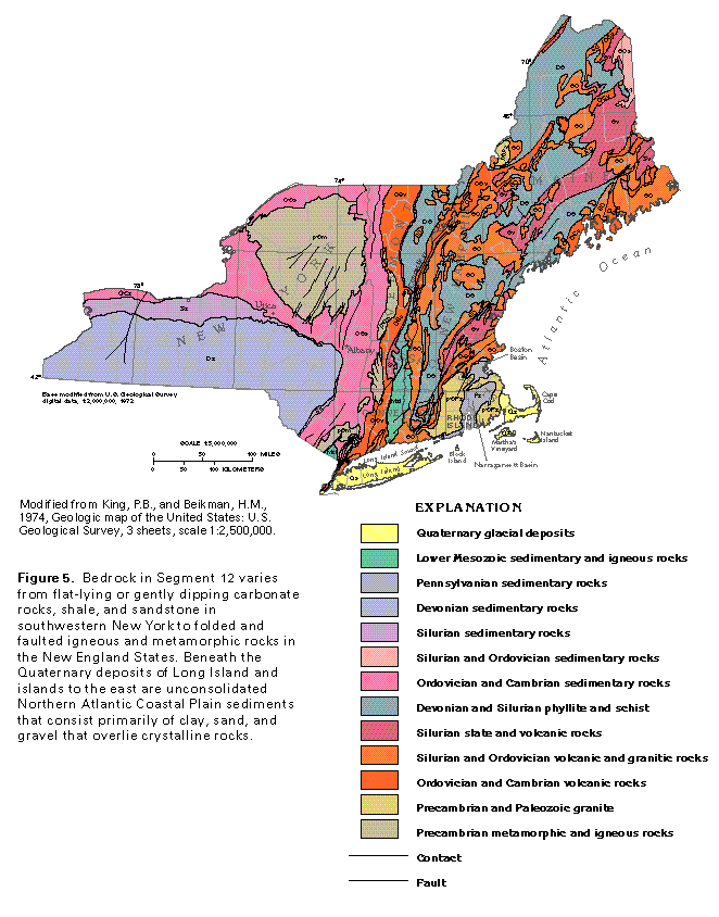
The seven States of Segment 12 are underlain by consolidated rocks that vary from sedimentary rocks in the west to igneous, metamorphic, and sedimentary rocks in the east (fig. 5). The rocks range in age from Precambrian to early Mesozoic, but those of Cambrian through Devonian age are the most widespread. During Pleistocene time, most of the seven-State area was covered by continental glaciers that planed off soil and weathered bedrock and redeposited these materials as a thin mantle of glacial debris over the bedrock surface. Sheetlike Quaternary glacial outwash deposits mantle Cape Cod and overlie Cretaceous Northern Atlantic Coastal Plain sediments on Long Island, Block Island, Martha's Vineyard, and Nantucket Island.
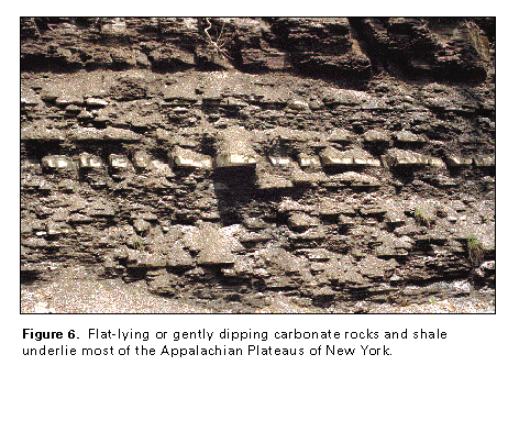
In New York, Precambrian metamorphic and igneous rocks underlie the Adirondack Province in the north and small parts of the Valley and Ridge and the New England Provinces in the south. The Adirondack Precambrian rocks are surrounded by Cambrian and Ordovician sedimentary rocks (primarily carbonate rocks, sandstone, and shale) that underlie the St. Lawrence Valley and parts of the Valley and Ridge, the Central Lowland, and the Appalachian Plateaus Provinces. In the Valley and Ridge Province, these rocks extend southward into New Jersey. A small area of Cambrian and Ordovician igneous and metamorphic rocks (primarily volcanic and carbonate rocks) is present in southern New York. Silurian and Devonian sedimentary rocks (primarily carbonate rocks and shale with some sandstone) underlie part of the Central Lowland and the Appalachian Plateaus in south-central and southwestern New York. Here, the rocks are either flat-lying or dip gently to the south (fig. 6) and have been deeply eroded. A small area of lower Mesozoic sedimentary and igneous rocks (primarily sandstone and conglomerate interbedded with flows of trap rock) underlies the northern tip of the Piedmont Province in southern New York (fig. 5); these rocks extend southward into New Jersey. On Long Island, Cretaceous Coastal Plain sediments (primarily clay, sand, and gravel) overlie igneous and metamorphic rocks that crop out in Connecticut. The surface of these rocks slopes to the southeast, and the overlying Coastal Plain sediments slope and thicken in the same direction. Quaternary glacial deposits (primarily outwash sand and gravel) cover the Coastal Plain sediments on Long Island to depths of as much as 600 feet.
In New York, major faults that trend northeastward are concentrated in two areas in the eastern part of the State. In the northern area, major faults are concentrated in the southeastern part of the Adirondack Province. Some of these faults extend southwestward into the Albany-Utica area. In the southern area along the New Jersey State line, vertical displacement along the major faults has been substantial; for example, Precambrian metamorphic rocks are now adjacent to lower Mesozoic sedimentary and igneous rocks deposited in a downfaulted trough.
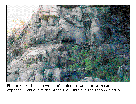
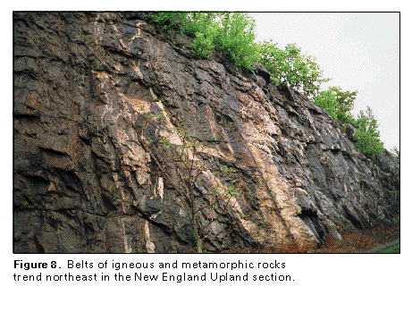
In New England, most consolidated rocks of Precambrian through early Mesozoic age are present in either north- or northeast-trending belts. Precambrian metamorphic rocks (primarily gneiss and mica schist) underlie parts of the Green Mountain Section in western New England; Precambrian igneous rocks (primarily granite) underlie parts of the Seaboard Lowland, the New England Upland, and the White Mountains Sections. Cambrian and Ordovician igneous and metamorphic rocks (primarily volcanic and carbonate rocks) are widespread and underlie much of the Green Mountain Section and parts of all other physiographic sections to the east. Cambrian and Ordovician sedimentary rocks (primarily carbonate rocks, sandstone, and shale) underlie most of the Taconic Section in western New England. Narrow bands of carbonate rocks (marble, dolomite, and limestone; fig. 7) are common in the valleys of the Green Mountain and the Taconic Sections. Ordovician, Silurian, and Devonian igneous and metamorphic rocks (primarily volcanic and intrusive granitic rocks, gneiss, marble, phyllite, schist, and slate; fig. 8) are present in northeast-trending belts throughout much of New England east of the Green Mountain and the Taconic Sections. Pennsylvanian sedimentary rocks (primarily sandstone, shale, and coal with some conglomerate) occupy two structural basins in the southern part of the Seaboard Lowland (fig. 5). In the Boston Basin, these sedimentary rocks are about 5,000 feet thick; in the Nar-ragansett Basin, they are about 10,000 feet thick. In the Connecticut River Valley of Connecticut and Massachusetts, a thick sequence of lower Mesozoic sedimentary and igneous rocks (primarily sandstone and conglomerate interbedded with flows of trap rock) occupies a downfaulted trough, which is similar to the one in southern New York. Cretaceous Coastal Plain sediments (primarily clay, sand, and gravel) underlie Block Island, Martha's Vineyard, and Nantucket Island and are completely covered by Quaternary glacial deposits (primarily out-wash sand and gravel). Similar Quaternary deposits, as much as 1,000 feet thick, mantle Cape Cod.
The geologic and hydrogeologic nomenclature used in this report differs from State to State because of independent geologic interpretations and varied distribution and lithology of rock units. A fairly consistent set of nomenclature, however, can be derived from the most commonly used rock names. Therefore, the nomenclature used in this report is basically a synthesis of that of the U.S. Geological Survey, the Connecticut Geological and Natural History Survey, the Maine Geological Survey, the Massachusetts Executive Office of Environmental Affairs, Massachusetts Coastal Zone Management, the New Hampshire Department of Environmental Services, the New York State Geological Survey, the Rhode Island Office of the State Geologist, and the Vermont Geological Survey. Individual sources for nomenclature are listed with each correlation chart prepared for this report.
MAJOR AQUIFERS
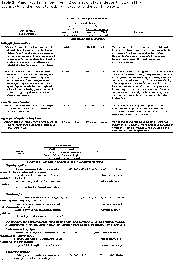
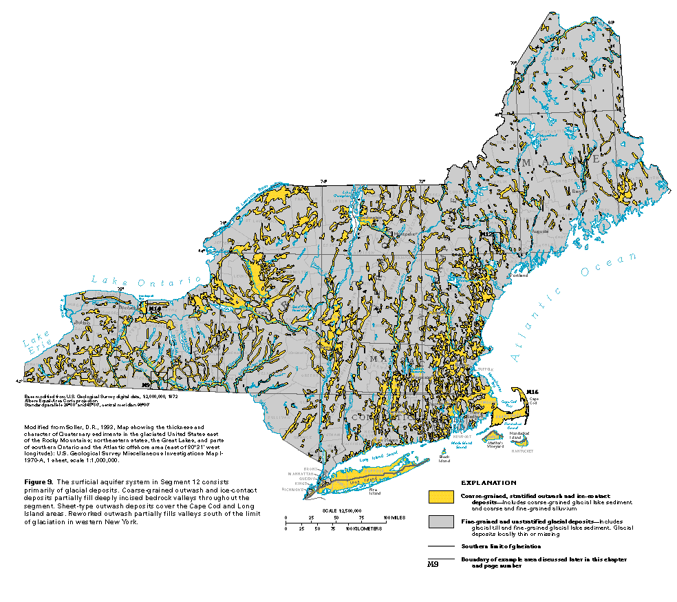
Aquifers (rock units that yield water to wells in usable quantities) are in three principal hydrogeologic environments in the seven States of Segment 12: unconsolidated glacial deposits, unconsolidated Coastal Plain sediments, and consolidated bedrock. These aquifers are grouped into principal aquifers or aquifer systems according to the characteristics of their ground-water flow systems and rock types. Two or more aquifers that are hydraulically connected or a set of individual aquifers that have common characteristics compose an aquifer system. Names and descriptions of the principal aquifers and aquifer systems in the segment, along with well characteristics and other information, are shown in table 2. The areas where the aquifers are exposed at or near land surface are shown in figure 9 and figure 10.
The most productive and widely used aquifers in Segment 12 are part of the surficial aquifer system (fig. 9, table 2). These aquifers primarily consist of deposits of sand and gravel which, for the most part, are individual valley-fill deposits of outwash and ice-contact materials laid down in numerous bedrock valleys by glacial meltwater. Principal exceptions are sheet-type outwash deposits of sand and gravel that compose the Cape Cod glacial aquifer and the upper glacial aquifer on Long Island. Minor aquifers of outwash sand and gravel are present on the islands of Nantucket, Martha's Vineyard, and Block Island.
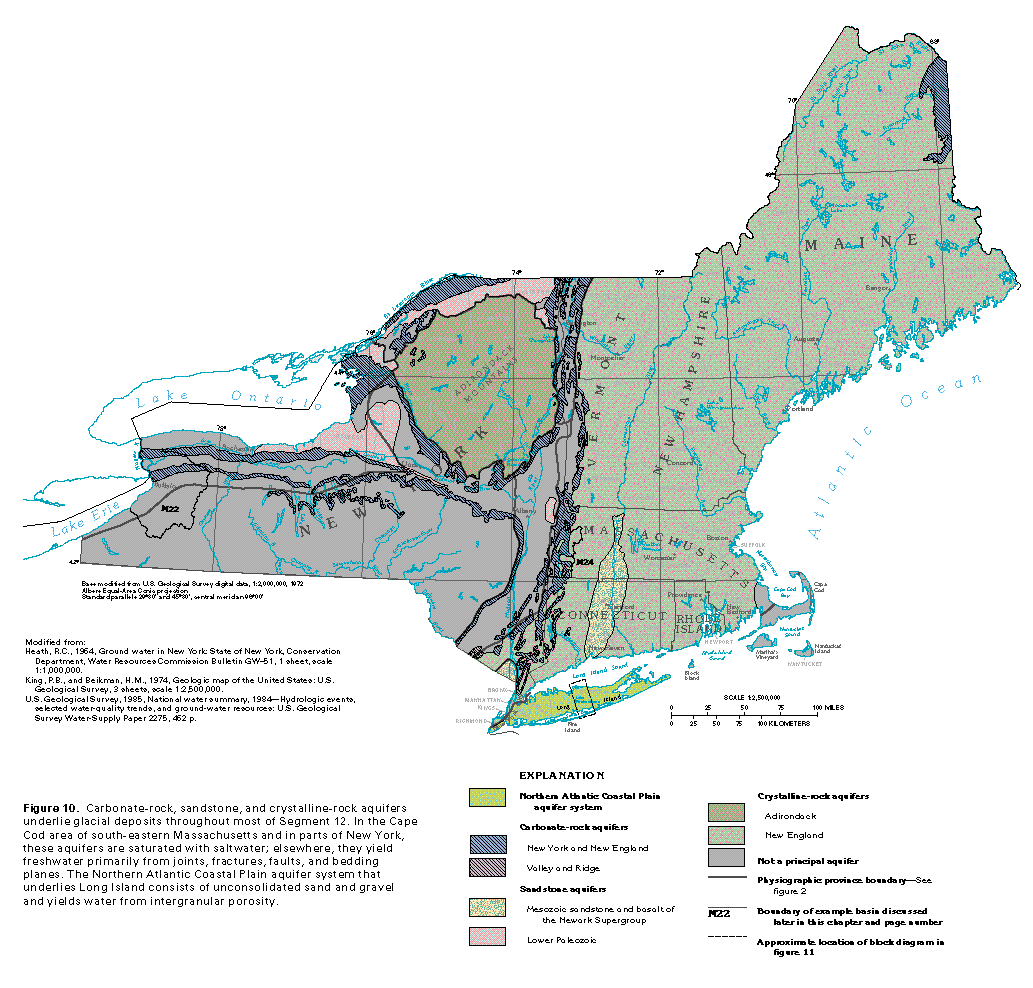
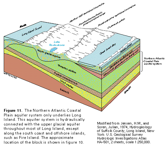
The Northern Atlantic Coastal Plain aquifer system (fig. 11, table 2) consists of the Magothy aquifer and the underlying Lloyd aquifer, which are separated by a leaky confining unit, the upper clay member of the Raritan Formation. Both aquifers consist primarily of sand; gravel is more prevalent in the Magothy aquifer than in the Lloyd aquifer. The Magothy aquifer provides most of the water for public supply in Queens, Nassau, and western Suffolk Counties. The Lloyd aquifer provides most of the water for public supply for the northwest-shore area of Long Island. In Segment 12, this aquifer system only underlies Long Island. Although equivalent Coastal Plain sediments underlie the glacial aquifers on Block Island, Martha's Vineyard, and Nantucket Island, the sediments contain brackish water or saltwater and are not used as a source of supply. Because the Northern Atlantic Coastal Plain aquifer system extends southward into Segment 11 of this Atlas, it is discussed in greater detail in Chapter L.
Consolidated bedrock aquifers in the Central Lowland, the St. Lawrence Valley, the Adirondack, the New England, and the Appalachian Plateaus Physiographic Provinces consist of carbonate rocks, sandstone, and crystalline rocks (fig. 10, table 2). Although these aquifers are the least productive of the major aquifers, they are important sources of domestic water supplies in areas where the surficial and Northern Atlantic Coastal Plain aquifer systems are not present. Because of their limited areal extent in Segment 12, aquifers in the Piedmont and the Valley and Ridge Provinces are only minor aquifers in the segment. These aquifers extend southward into Segment 11 of this Atlas and are discussed in greater detail in Chapter L.
SURFICIAL AQUIFER SYSTEM
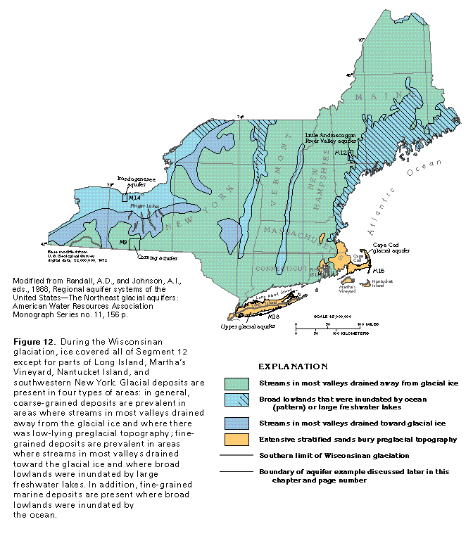
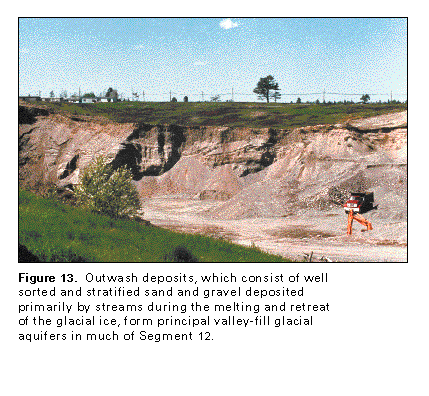
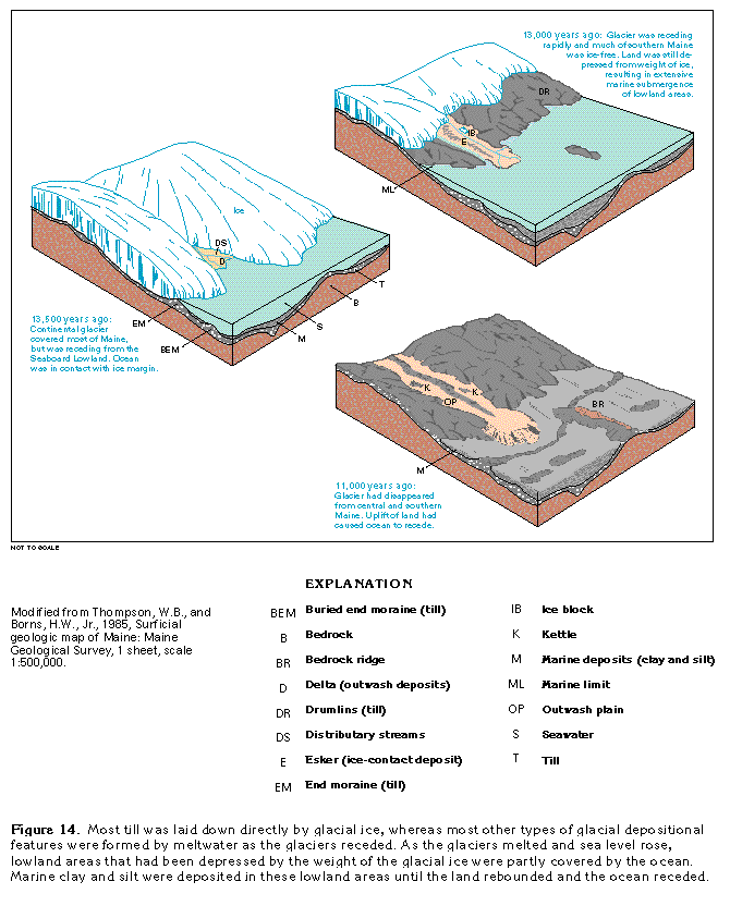
The surficial aquifer system in Segment 12 consists of glacial deposits of sand and gravel that were laid down during several advances and retreats of continental glaciers that encroached from the north or northwest. The glacial stage between the most recent advance, which took place about 21,000 years ago, and final retreat, which occurred about 12,000 years ago, is termed Wisconsinan. During this stage, ice covered all of Segment 12, except for parts of Long Island, Martha's Vineyard, Nantucket Island, and southwestern New York (fig. 12). The glacial ice and meltwater derived from the ice laid down several characteristic deposits. Till, which consists of unsorted and unstratified material ranging in size from clay to boulders, was deposited directly from the ice. Meltwater laid down outwash, which consists mostly of stratified deposits of sand and gravel (figs. 13, 14); ice-contact deposits, which consist primarily of poorly stratified sand and gravel; and glacial-lake deposits, which consist of mostly clay, silt, and fine sand. These deposits are present in four types of areas within Segment 12 (fig. 12).
In all the areas shown in figure 12, till was plastered to the deeply eroded and glacially scoured bedrock surface under the advancing glacier. As the ice melted, the till generally remained in place, which left a relatively continuous sheet over the bedrock throughout Segment 12. Till yields little water be-cause it generally is unsorted and unstratified and contains a large amount of fine-grained material. Before the development of deep well-drilling equipment, however, till was developed for domestic water supplies by constructing large-diameter dug wells that penetrated only a few feet below the water table. Yields from wells completed in till generally range from less than 1 to only a few gallons per minute; rarely, yields might be as much as 20 gallons per minute.
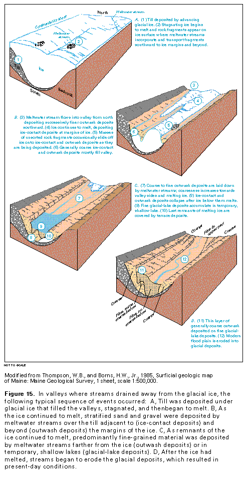
In areas where streams in most valleys drained away from the glacial ice (fig. 12), stratified glacial drift, including outwash, ice-contact, and glacial-lake deposits, was deposited mostly during stagnation or melting of the ice sheet. Abundant meltwater flowed down a steep gradient provided by the ice and transported rock fragments released from the melting ice (fig. 15A) to the ice margins and beyond. Sand and gravel deposited at the face of the ice sheet or in cracks in the ice formed ice-contact deposits. Coarse-grained sand and gravel outwash was deposited by the swiftly moving, sediment-laden streams as they flowed across the land surface (fig. 15B). Outwash was laid down in front of the ice as the streams deposited successively finer material farther and farther from the ice. As the glacial ice continued to melt and retreat, deposits of clay, silt, and fine to coarse sand were laid down toward the middle of the valleys and coarse-grained terrace deposits formed at the sides of the valleys (fig. 15C). If a lake temporarily formed downvalley, then clay, silt, and fine sand were deposited on the lake bottom (fig. 15C). After all the glacial ice in the valleys had melted, the land rebounded, base level was lowered, and streams began to erode the glacial deposits, which resulted in present-day conditions as shown in figure 15D. The streams are now depositing alluvium that consists primarily of reworked glacial material. The coarse-grained outwash, ice-contact, and alluvial deposits form the productive valley-fill glacial aquifers of the surficial aquifer system. Where the valley-fill glacial aquifers consist primarily of ice-contact deposits, well yields commonly range from 10 to 1,000 gallons per minute and might be as much as about 3,000 gallons per minute. Where these aquifers consist primarily of outwash deposits, well yields commonly range from 10 to 400 gallons per minute and might be as much as 2,000 gallons per minute.
Broad lowland areas (fig. 12) were inundated by either the ocean or freshwater lakes during the melting and retreat of the glacial ice. Along parts of the Atlantic coast in Segment 12, the immense weight of the glacial ice temporarily depressed the land surface below sea level (fig. 14). As the glacial ice melted and retreated and before the land surface rebounded above sea level, broad lowlands were inundated by the ocean. Marine clay and silt were deposited over till and other fine- and coarse-grained glacial deposits in these lowlands. Along the ancestral Great Lakes and St. Lawrence River drainage system, large freshwater lakes formed south of the melting glacial ice and inundated broad lowlands. Mostly clay and silt were deposited in these lakes; however, some ice-contact and outwash deposits of sand and gravel were deposited locally.
In valleys where streams either drained toward the glacial ice (fig. 12) or drained away from the ice and were dammed by sediments, large lakes commonly formed. Sediments deposited in these lakes were primarily clay, silt, and very fine to fine sand that accumulated in places to a thickness of several hundred feet. Although sand and gravel of deltaic or alluvial origin also were deposited, these coarse-grained materials generally have limited saturated thickness and do not yield large quantities of water. In these valleys, therefore, valley-fill glacial aquifers are few and are not major sources of water.
Areas of low preglacial topography at the terminus of the glacier, such as the Cape Cod area and Long Island (fig. 12), were buried by extensive, thick glacial deposits-as much as 1,000 feet thick on Cape Cod and as much as 600 feet thick on Long Island. All types of glacial deposits are present in both locations. In the Cape Cod area, the predominant glacial deposits are ice-contact and outwash deposits that consist primarily of coarse sand and gravel. These deposits are intermingled in places with till from terminal moraines and layers of glacial-lake deposits that consist primarily of clay and silt. The sand and gravel form the productive Cape Cod glacial aquifer. The maximum thickness of the aquifer is about 200 feet and it is the only source of fresh ground water in the Cape Cod area. Well yields commonly range from 100 to 1,000 gal-lons per minute and might be as much as 2,000 gallons per minute. On Long Island, glacial deposits are sandy till that is present in two westward-coalescing terminal moraines and outwash deposits that are present north of, between, and south of the two moraines. The outwash and moraine deposits form the productive upper glacial aquifer on Long Island. A well-developed ground-water flow system, which is present throughout the aquifer, is hydraulically connected with that of the underlying Northern Atlantic Coastal Plain aquifer system in most places. Wells completed in the upper glacial aquifer commonly yield from 50 to 1,000 gallons per minute and might yield 1,500 gallons per minute.
Because of the diversity of aquifers within the surficial aquifer system, examples of typical aquifers (figs. 9 and 12) are listed here and described in detail later in the chapter:
· The Corning aquifer is typical of valley-fill glacial aquifers deposited by meltwater streams that flowed away from the glacial ice in upland valleys.
· The Little Androscoggin River Valley aquifer is typical of valley-fill glacial aquifers deposited by meltwater streams that flowed away from the glacial ice in lowland valleys that had been either partly or completely inundated by the ocean; the outwash that composes the aquifer was deposited, at least partly, over marine sediments.
· The Irondogenesee aquifer is typical of valley-fill glacial aquifers deposited by meltwater streams that flowed toward the glacial ice in lowland valleys that were either partly or completely inundated later by large freshwater lakes; fine-grained glacial-lake sediments were deposited, at least partly, over the coarse-grained outwash that composes the aquifers.
· The Cape Cod glacial aquifer and the upper glacial aquifer on Long Island are typical of aquifers in sheetlike glacial deposits that buried low-lying preglacial topography at the glacial terminus. The Northern Atlantic Coastal Plain aquifer system on Long Island and the upper glacial aquifer are described jointly because of the hydraulic connection between them.
An example of aquifers in valleys where streams drained toward the glacial ice (fig. 12) is not presented because most of these valleys contain fine-grained glacial-lake deposits that generally do not form productive aquifers. The Finger Lakes of western New York occupy some of these valleys that are partly filled with fine-grained deposits.
NORTHERN ATLANTIC COASTAL PLAIN AQUIFER SYSTEM
The Northern Atlantic Coastal Plain aquifer system, which underlies Long Island, overlies crystalline rocks that slope southeastward (fig. 11). The unconsolidated Coastal Plain sediments that compose the aquifer system slope and thicken in the same direction. The major water-yielding units are the Magothy Formation and the Lloyd Sand Member of the Raritan Formation.
The entire Magothy Formation forms the Magothy aquifer, which is a fine to medium sand with some clay and coarse sand and gravel. Near Great South Bay, the Magothy aquifer is overlain by a confining unit that consists of the Gardiners Clay and greensand of the Monmouth Group. Elsewhere, the Magothy aquifer is overlain by and hydraulically connected with the upper glacial aquifer. Yields of wells completed in the Magothy aquifer commonly range from 50 to 1,200 gallons per minute and might exceed 2,000 gallons per minute. The Magothy aquifer is the main source of water for public supply in Queens, Nassau, and western Suffolk Counties.
The Raritan Formation consists of an unnamed upper clay member, which is a leaky confining unit, and the lower Lloyd Sand Member that forms the Lloyd aquifer. The Lloyd aquifer consists of fine to coarse sand and gravel, commonly within a clayey matrix, interbedded with lenses and layers of clay and silty clay. Wells completed in the Lloyd aquifer commonly yield 50 to 1,000 gallons per minute and might yield as much as 1,200 gallons per minute. The Lloyd aquifer is the main source of water for public supply in the area along the northwestern shore of Long Island.
CARBONATE-ROCK, SANDSTONE, AND CRYSTALLINE-ROCK AQUIFERS
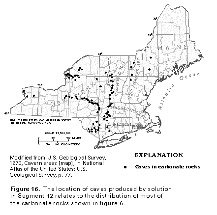
Consolidated bedrock aquifers in the Central Lowland, the St. Lawrence Valley, the Adirondack, the New England, and the Appalachian Plateaus Physiographic Provinces in Segment 12 are in consolidated rocks of sedimentary, igneous, and metamorphic origin (fig. 10). Some of these aquifers consist of carbonate rocks (primarily limestone, dolomite, and marble) and sandstone (including some associated conglomerate, siltstone, and shale); others are crystalline rocks of igneous origin (pegmatite, granite, granodiorite, diorite, and gabbro), and still others are of metamorphic origin (argillite, slate, quartzite, schist, and gneiss). These consolidated rocks yield water primarily from bedding planes, fractures, joints, and faults, rather than from intergranular pores. Carbonate rocks generally yield more water than other types of consolidated rocks because carbonate rocks are subject to dissolution by slightly acidic ground water. Dissolution along openings, such as bedding planes, fractures, and joints, has enlarged these openings and increased the permeability of the carbonate rocks regardless of whether they are limestone and dolomite or have been metamorphosed to marble. Caves formed by the dissolution of carbonate rocks in Segment 12 are concentrated in northwestern and eastern New York, the western parts of Connecticut, Massachusetts, and Vermont (fig. 16), and along the outcrop bands of carbonate rock.
Carbonate-rock aquifers in Segment 12 are present mostly in New York and the western parts of Vermont, Massachusetts, and Connecticut (fig. 10). In New York, aquifers in carbonate rocks of Cambrian and Ordovician ages partially surround the Adirondack Mountains and crop out in the Central Lowland Physiographic Province and the valleys of the St. Lawrence and the Mohawk Rivers. Carbonate-rock aquifers also crop out along the escarpment that marks the northern and eastern edges of the Appalachian Plateaus Physiographic Province in western New York. A belt of limestone, dolomite, and marble that extends along the eastern edge of New York and the western edge of Connecticut, Massachusetts, and Vermont forms carbonate-rock aquifers. Carbonate rocks of Silurian age form an aquifer in northeastern Maine, where they supply about 4 million gallons per day, primarily for industrial and domestic uses.
Carbonate-rock aquifers in Segment 12 generally yield 10 to 30 gallons per minute to wells. Yields can be larger or smaller, however, depending on the degree of fracturing and the number and size of dissolution features in the rock; for example, yields of as much as 1,000 gallons per minute have been reported in some wells in carbonate-rock aquifers with numerous dissolution openings. Two examples of carbonate-rock aquifers are discussed in detail later in the chapter: the Lake Erie-Niagara River Basin in western New York and the Housatonic River Basin in western New England.
Sandstone aquifers in Segment 12 are present in New York and in the central parts of Massachusetts and Connecticut (fig. 10). Sandstone aquifers in New York include the Cambrian Potsdam Sandstone in the St. Lawrence Valley and sandstones of the Ordovician Medina Group in the Central Lowland Province and the Mohawk Valley. The sandstones in New York are productive aquifers which yield from 50 to 100 gallons per minute to wells. Water in these aquifers generally is confined.
Arkosic sandstone, conglomerate, shale, and interbedded trap rock form the lower Mesozoic Newark Supergroup, which occurs in fault-block basins that underlie the Connecticut River Valley in Connecticut and Massachusetts and a small area of southeastern New York. The sandstone in the Connecticut River Valley is very thick and dips toward a fault on the eastern side of the basin. In New York, rocks of the Newark Supergroup dip westward and are in fault contact with Precambrian crys- talline rocks.
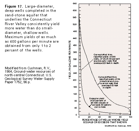
The yields of wells completed in the sandstone aquifer in the Connecticut River Valley (fig. 17) reflect the effects of well diameter, well depth, and use of the water. Yields of small-diameter, shallow, domestic wells commonly range from 2 to 50 gallons per minute, but yields of large-diameter, deep, industrial wells might exceed 600 gallons per minute. Water in this aquifer is unconfined to partly confined in the uppermost 200 feet but might be confined at depth.
Crystalline-rock aquifers are the least productive of the major aquifers in Segment 12 (fig. 10). Well yields commonly range from 2 to 10 gallons per minute, which generally are sufficient only for domestic and commercial and small public supplies. Some reported well yields, however, might exceed 500 gallons per minute. Crystalline-rock aquifers provide water for the majority of homes in rural New England. Water in these aquifers generally is unconfined but is locally confined at depth.
The chemical quality of the water in each of the major aquifers and aquifer systems of Segment 12 generally is suitable for most uses, including human consumption. Water quality, however, differs among the aquifers as a result of natural conditions and human activities that, locally, might prevent the use or require treatment of the water.
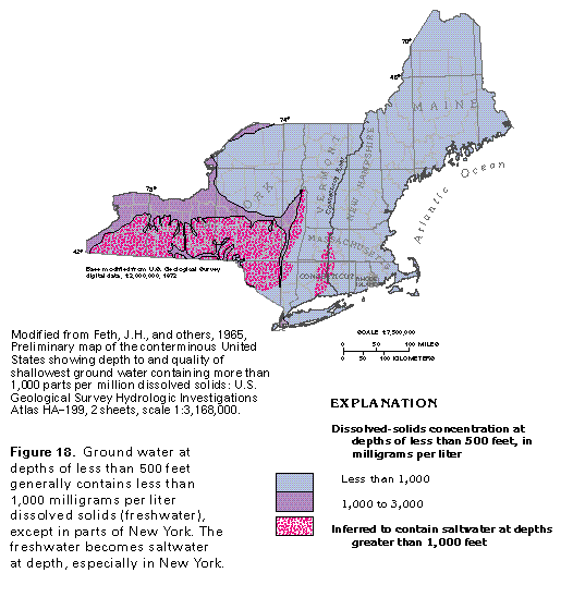
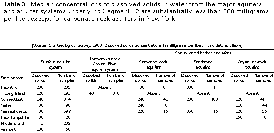
Ground-water quality is the result of dissolved material in the water and is primarily related to the (1) mineral composition and solubility of the rocks that make up the aquifer, (2) time that the water is in contact with the rock, (3) surface area of rock exposed to the water, (4) chemistry of water moving into the aquifer from other aquifers, and (5) introduction or induced movement of contaminants. In Segment 12, each of these factors influences ground-water quality. A summary, by aquifer type in each State, of the general chemical character of water in the aquifers and the aquifer systems of the segment is based on median concentrations of dissolved solids and is shown in figure 18 and table 3. The concentration of dissolved solids in ground water generally increases with depth, and some aquifers contain saltwater or brine in their deeper parts.
Aquifers that are part of the surficial aquifer system in Segment 12 consist mainly of stratified drift. Generally, they are composed of unconsolidated layers of sand and gravel that are of small areal extent, less than 100 feet thick, and unconfined. Mineral composition of the sand and gravel is related to that of the parent bedrock eroded by the glaciers. The sand and gravel commonly are composed of more than 99 percent quartz and feldspar, minerals that are chemically stable, nonreactive, and almost insoluble in water. In places, however, the sand and gravel contain fragments of carbonate rocks, which are soluble in water. Although the sand and gravel has an extremely large surface area exposed to the water, the deposits are extremely permeable, and the water moves rapidly through them, generally along very short flow paths; therefore, the water is in contact with aquifer minerals for only a brief time. Because they are shallow, unconfined, and generally overlain by a highly permeable unsaturated zone through which they are recharged, the aquifers are susceptible to contamination. The quality of the water in the surficial aquifer system is determined by the chemistry of the minerals that comprise the aquifer and by the chemistry of the water that enters the aquifer system where bedrock aquifers discharge into it.
Median dissolved-solids concentrations in water from the surficial aquifer system in Segment 12 range from 75 to 200 milligrams per liter (table 3), which is substantially less than the 500-milligram-per-liter limit for public supply recommended by the U.S. Environmental Protection Agency. Median concentrations are least and range between 75 and 140 milli-grams per liter in the New England States where these aquifers consist primarily of quartz and feldspar. Water in the extensive carbonate bedrock in New York commonly discharges into the surficial aquifer system, and the aquifers contain carbonate-rock fragments for several miles south of carbonate bedrock outcrops; these factors explain the median dissolved-solids concentrations of 200 milligrams per liter in some areas. Another factor that contributes to the large median concentrations in New York is the discharge of mineralized water from carbonate-rock aquifers along the margins of the Appalachian Plateaus Province and from gypsum-bearing shale in the Central Lowland Province into the surficial aquifer system.
Water from the surficial aquifer system in southern New York is hard and slightly alkaline because the aquifers contain fragments of carbonate rocks. Elsewhere in New York and in the New England States, water from the surficial aquifer system is acidic and soft. The acidity of the water makes it corrosive to metal and concrete pipes. Excessive iron and manganese concentrations in water from the surficial aquifer system is a segmentwide problem that, in many areas, requires treatment of the water to remove these metals. Saltwater is present locally in the surficial aquifer system as a consequence of excessive ground-water withdrawals, especially in coastal areas of western Long Island, Connecticut, and Massachusetts. The widespread use of deicing chemicals on roads in the segment also can introduce saltwater into the aquifer system. Other common sources of local contamination throughout the segment are effluent from septic systems and leaching of agricultural chemicals.
The sand and gravel aquifers of the Northern Atlantic Coastal Plain aquifer system have characteristics similar to those of the surficial aquifer system: (1) they are predominantly composed of quartz and feldspar, (2) a large aquifer-mineral surface area is exposed to the water, but the water moves along short flow paths, which results in brief water-mineral contact times, and (3) the upper aquifer (the Magothy aquifer) contains water generally under unconfined conditions. Median dissolved-solids concentrations in water from the Magothy aquifer and the underlying Lloyd aquifer are only about 40 milligrams per liter (table 3). The water is soft and slightly acidic. Locally, large iron and manganese concentrations from natural sources are a problem in water from the Magothy aquifer. There is a potential for saltwater intrusion into the aquifer system along most of the periphery of Long Island. Because the island is densely populated and the overlying upper glacial aquifer is extremely permeable in many places, local contamination of the Magothy aquifer from sources on the land surface is an increasing problem.
Carbonate-rock aquifers consist of limestone, dolomite, and marble and generally are the most soluble of the aquifers in Segment 12. For this reason, median dissolved-solids concentrations in water from carbonate-rock aquifers are among the largest-220 to 700 milligrams per liter-in the segment (table 3). Water from carbonate-rock aquifers is characteristically very hard and slightly alkaline. Sodium, fluoride, and sulfate concentrations typically are small. Water in the carbonate-rock aquifers at depth in the Appalachian Plateaus Physiographic Province is inferred to be saltwater (fig. 18) because of slow circulation along long flow paths and the leaching of evaporite deposits that contain gypsum in the bedrock. Elsewhere, circulation is faster along shorter flow paths. Where carbonate-rock aquifers are exposed at the land surface, they are susceptible to contamination from the land surface because of their solution-enhanced permeability.
Sandstone aquifers in New York are primarily in the northern one-half of the State, and are characterized by fracture rather than by intergranular permeability. The aquifers generally contain very hard water. The median dissolved-solids concentration is about 300 milligrams per liter (table 3), and the median chloride concentration is about 100 milligrams per liter. Dissolved-solids and chloride concentrations increase with depth, and saltwater is present at depths of less than 500 feet in some areas (fig. 18). The susceptibility of these aquifers to contamination from the land surface is greatest where they are exposed at the land surface.
The sandstone aquifer in the Connecticut River Valley is interbedded with shale, conglomerate, and trap rock. These rocks contain mineral sources of fluoride, sulfate, copper, lead, zinc, and uranium, and these ions occur as constituents in trace amounts in water from the aquifer. The aquifer is characterized by fracture rather than by intergranular permeability. Water in the upper 200 to 300 feet of the aquifer, where flow paths are shortest, is moderately hard and slightly alkaline; median dissolved-solids concentrations are 200 milligrams per liter in Connecticut and 360 milligrams per liter in Massachusetts (table 3). At depths of greater than 1,000 feet, the aquifer is inferred to contain saltwater (fig. 18). The susceptibility of the aquifer to contamination from the land surface is similar to that of sandstone aquifers in New York.
Crystalline-rock aquifers consist of almost insoluble igneous and metamorphic rock. These aquifers are characterized by shallow fracture systems that store and transmit water. The shallow fracture systems that have small surface areas and rapid water movement along short flow paths only allow minimal dissolution of the rocks. As a result, median dissolved-solids concentrations in water from these aquifers range from 110 to 150 milligrams per liter in Connecticut, Massachusetts, Maine, and New Hampshire (table 3). Water in crystalline-rock aquifers is similar in quality to water in aquifers of the surficial aquifer system. Locally, excessive concentrations of iron, manganese, and sulfate are present. Large concentrations of radon, a radioactive gas that is a decay product of the uranium minerals present in granite and some metamorphic rocks, have been reported in water from the crystalline-rock aquifers in all of the New England States except Vermont.The susceptibility of the crystalline-rock aquifers to contamination from the land surface is greatest where they are exposed at the land surface.
FRESH GROUND-WATER WITHDRAWALS
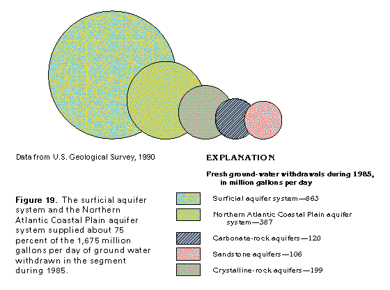
Fresh ground-water withdrawals in Segment 12 totaled about 1,675 million gallons per day during 1985. About 51 percent, or about 863 million gallons per day, was withdrawn from the surficial aquifer system (fig. 19) primarily on Long Island and Cape Cod and from numerous valley-fill glacial aquifers throughout the segment. The Magothy and the Lloyd aquifers that compose the Northern Atlantic Coastal Plain aquifer system underlying Long Island supplied about 23 percent of total withdrawals or about 387 million gallons per day. Withdrawals from bedrock aquifers in the Central Lowland, the St. Lawrence Valley, the Adirondack, the New England, and the Appalachian Plateaus Physiographic Provinces, totaled about 427 million gallons per day. Crystalline-rock aquifers in the New England States and the Adirondack Mountains of New York provided nearly 12 percent of total withdrawals, or about 199 million gallons per day. Carbonate-rock aquifers, primarily in western New York and in western Connecticut, Massachusetts, and Vermont, produced about 120 million gallons per day, or about 7 percent of total withdrawals. Sandstone aquifers, primarily in western and northern New York and in the Connecticut River Valley, were the source for about 106 million gallons per day, or about 6 percent of total withdrawals. Shallow dug wells in till throughout the segment were estimated to supply about 7 million gallons per day, or about 0.4 percent of total withdrawals.
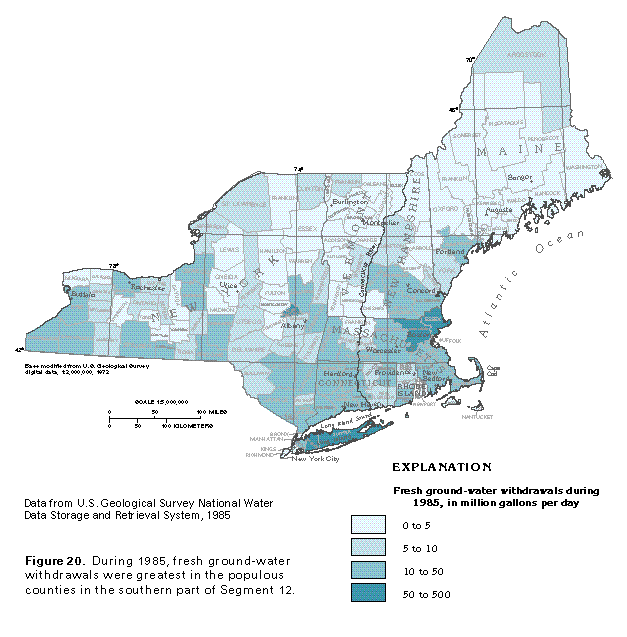
The distribution of ground-water withdrawals from all aquifers and aquifer systems during 1985 is shown by county in figure 20. The largest withdrawals, which ranged from 50 to 500 million gallons per day, were on Long Island, where ground water supplies a population of about 3.5 million people; in northeastern Massachusetts; and in Schenectady County, N.Y. The populous counties of southern and east-central New York, eastern and southwestern Massachusetts, and southern New Hampshire withdrew from 10 to 50 million gallons per day during 1985. Counties that surround large cities in western New York and southern Maine similarly withdrew from 10 to 50 million gallons per day during 1985.
In the sparsely populated areas of Segment 12, which include much of rural New York, Vermont, New Hampshire, and Maine, water demand is small, and withdrawals were less than 5 million gallons per day per county during 1985. Fresh ground-water withdrawals in Aroostook County, the northernmost county in Maine, were 5 to 10 million gallons per day during 1985, which reflects industrial, domestic, and agricultural use of water from carbonate-rock aquifers in the eastern part of the county.
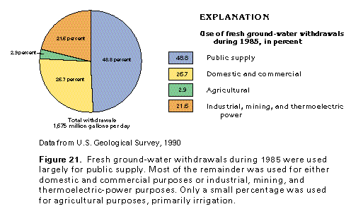
The various uses of the fresh ground-water withdrawals in Segment 12 during 1985 are shown in figure 21. By far the largest use of freshwater, nearly one-half of the total, was for public supply in this populous segment. Much of the remaining one-half was approximately divided between domestic and commercial uses (about 27 percent) and industrial, mining, and thermoelectric power uses (about 21 percent). Freshwater withdrawn for agricultural purposes accounted for only about 3 percent of the total.