INTRODUCTION
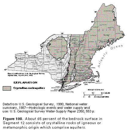
The bedrock surface of about 65 percent of the area of Segment 12 is crystalline rock of igneous or metamorphic origin (fig. 108). Glacial deposits of outwash, ice contact, and lacustrine sand and gravel fill ancient valleys cut into the bedrock surface and form the principal aquifers of the segment. However, in uplands and other areas where thin or barely permeable deposits of till blanket the bedrock, surficial aquifers are not readily available, and the bedrock itself is an important source of water.
GEOHYDROLOGY
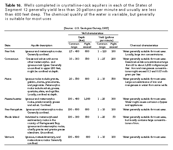
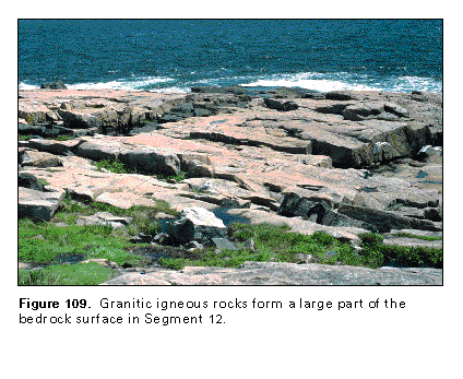
Igneous and metamorphic rocks that form crystalline-rock aquifers are described by State in table 16. Well-indurated sedimentary rocks that exist in a few places are mapped with the crystalline rocks in this chapter because they have similar hydraulic characteristics. Although the crystalline rocks are geologically complex with a structural fabric that generally trends northeast, movement of water through the rocks is totally dependent on the presence of secondary openings; rock type has little or no effect on ground-water flow. Examples of granitic igneous rocks and metavolcanic metamorphic rocks are shown in figures 109 and 110.
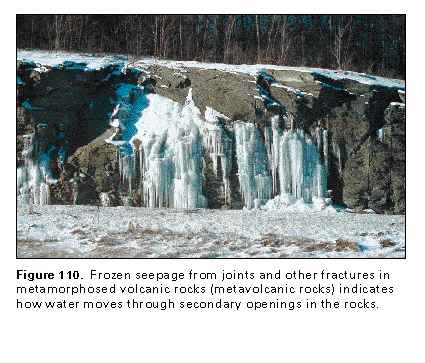
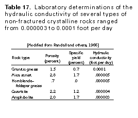
Spaces between the individual mineral crystals of the crystalline rocks are few, microscopically small, and generally unconnected. Consequently, the intergranular porosity of crystalline rocks is so small as to be insignificant. Samples of several types of crystalline rocks were tested in the laboratory and found to range in hydraulic conductivity from 0.000003 to 0.0001 foot per day (table 17). A well that penetrates 200 feet of these crystalline rocks would have a yield of only 0.007 gallon per minute if all the water had to enter the well through intergranular pore spaces. Virtually all wells completed in crystalline rocks yield considerably more water; therefore, water reaches the wells through conduits other than intergranular pore spaces. Many studies have determined that virtually all movement of water in crystalline rocks is through fractures or joints in the rocks. Fractures are readily visible in most outcrops in roadcuts, and, after a rainstorm, water can occasionally be observed seeping from these fractures; for example, seepage from a metavolcanic-rock outcrop, frozen into icicles, is shown in figure 110.
Fracture permeability in crystalline rocks is the result of the cooling of igneous rocks, deformation of igneous and metamorphic rocks, faulting, jointing and weathering. Openings commonly are present along relict bedding planes, cleavage planes, foliation, and other zones of weakness in the rocks; these openings typically are heterogeneous in spacing, orientation, size, and degree of interconnection. Generally, openings in the rocks are most prevalent near land surface and decrease in number and size with depth. Thus, wells commonly are not drilled past depths of 300 to 600 feet (table 16), but exceptions indicate that deep water-yielding fractures are present. The specific capacity of wells, or the yield of the well divided by the distance the water level is drawn down by pumping, is one way to compare well performance. Data from 147 wells completed in crystalline rocks in Connecticut show that yields per foot of saturated crystalline rock decrease as well depth increases.
Fracture permeability in the upper part of most crystalline rocks in Segment 12 appears to be adequate to support a ground-water flow system. Thus, water from precipitation recharges the fracture system either directly at outcrop areas or indirectly through overlying glacial deposits. Recharge occurs primarily in the uplands, and the water moves down a hy-draulic gradient to stream valleys where it is discharged either to the valley fill or to streams or other surface-water bodies.
Although the crystalline rocks in Segment 12 transmit water, the volume of water in storage in the fracture system of these rocks generally is small, and drawdown is large in pumped wells that produce only small quantities of water. Water that is stored in overlying glacial deposits or water in nearby streams or other surface-water bodies, however, commonly is hydraulically connected with the bedrock fracture system and might provide large quantities of water as recharge induced by pumping the wells completed in the crystalline rocks. Thus, although the common range of well yields is only a few gallons per minute (table 16), yields from some wells may exceed 100 to 500 gallons per minute.
GROUND-WATER QUALITY
Water in the crystalline-rock aquifers generally is suitable for most uses because crystalline rocks generally are composed of virtually insoluble minerals, water is in contact with a relatively small surface area in the joints and fractures, and water movement through the joints and fractures generally is rapid and along short flow paths. Consequently, only small quantities of minerals are dissolved by the water. Recharge to the crystalline-rock aquifers, however, is at least partly derived from water percolating downward through the overlying surficial aquifer system. This water has its own unique chemical characteristics. Thus, the chemical quality of water in the crystalline-rock aquifers generally is a composite of the chemical quality of water from both sources. Locally, water in the crystalline-rock aquifers contains excessive concentrations of iron, manganese, sulfate, or radon.
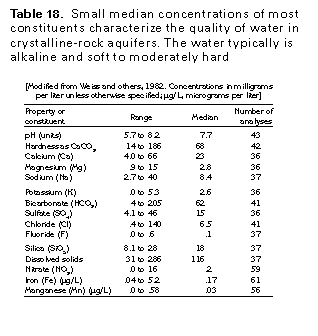
The chemical and physical properties of water in the crystalline-rock aquifers of Segment 12 are exemplified by the median values and ranges of constituents or properties of samples collected from 36 to 61 wells in the lower Connecticut River basin in Connecticut (table 18). The median dissolved-solids concentration in water from 37 different wells completed in the crystalline-rock aquifer was only 116 milligrams per liter. The water typically is soft to moderately hard and alkaline and generally contains only moderate concentrations of most constituents except iron, which is a problem in some areas.
FRESH GROUND-WATER WITHDRAWALS
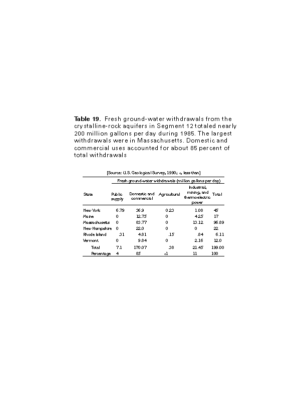
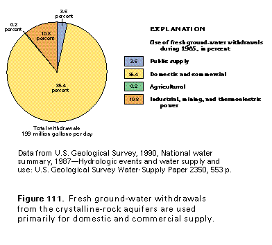
Fresh ground-water withdrawals from the crystalline-rock aquifers in Segment 12 during 1985 totaled nearly 200 million gallons per day (table 19). Water was withdrawn from the aquifer primarily for domestic and commercial uses, which accounted for about 85 percent of the total withdrawals
(fig. 111) or about 170 million gallons per day. Industrial, mining, and thermoelectric power withdrawals accounted for about 11 percent of the total withdrawals or about 21.5 million gallons per day. Agricultural and public-supply uses accounted for only about 4 percent of the total withdrawals or about 7.5 million gallons per day, most of which was withdrawn for public supply.