
BEDROCK AQUIFERS
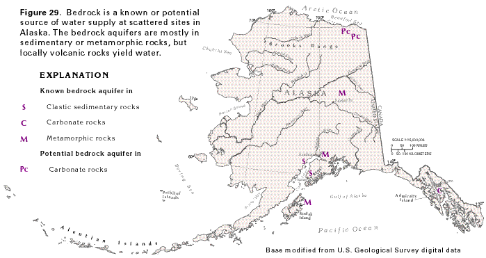
Consolidated rocks are exposed at the land surface over about 70 percent of Alaska, but are generally less permeable than the unconsolidated deposits discussed in the preceding section of this report. Accordingly, the consolidated rocks are used as a source of water supply only where the unconsolidated deposits are absent, thin, or poorly permeable. Information about the water-yielding characteristics of the consolidated rocks, which are called bedrock aquifers in this report, is scarce. The locations of known bedrock aquifers and the aquifer rock type are shown in figure 29.
Sedimentary bedrock that underlies the southwestern part of the Kenai Peninsula (fig. 29) provides water to numerous domestic wells and supplies some small communities. Poorly consolidated sandstone that is part of the Kenai Group of Tertiary age yields most of the water, but some water is also obtained from coal beds and seams within the group. Interbedded siltstone and claystone yield no water. Although most wells completed in strata of the Kenai Group yield less than 20 gallons per minute, yields of as much as 80 gallons per minute are reported locally. Several springs and seeps near Homer on the Kenai Peninsula discharge from beds of the Kenai Group. Sparse data from the Capps coal field, north of Cook Inlet across from the Kenai Peninsula, indicate that Tertiary beds of coal and poorly consolidated sandstone and conglomerate yield as much as 60 gallons per minute to wells. Water withdrawn from the Kenai Group and the strata in the Capps coal field locally contains objectionable concentrations of iron and hydrogen sulfide, both probably derived from the coal beds. Locally, methane gas that has been reported in water from some wells near Homer is also probably derived from the coal units.
Carbonate rocks comprise known or potential aquifers in some parts of Alaska. In the eastern part of the Brooks Range, at least 25 springs are known to discharge from carbonate rocks; the discharge of one of these springs is as much as 16,000 gallons per minute. The springs are thought to discharge from a network of solution cavities and conduits that have developed by partial dissolution of the carbonate rocks. Carbonate rocks on Admiralty Island in southeast Alaska locally yield large quantities of ground water, probably from a system of caves and solution conduits.
Metamorphic rocks yield water in substantial quantities only where they have been fractured. Perhaps the most important area underlain by a metamorphic-rock aquifer is north and northeast of Fairbanks, where wells completed in fractured schist supply approximately one-half of the population. Fractured slate and metagreywacke in the upland areas near Anchorage supply water to numerous domestic wells. Fractured slate and metamorphosed volcanic rocks on Kodiak Island generally yield less than 15 gallons per minute to wells, but locally yield as much as 100 gallons per minute.
Little is known about the water-yielding potential of the widespread volcanic rocks in Alaska, but they are permeable at least locally, where hot springs issue from them. The permeability in these rocks may be a combination of fractures produced when the rocks cooled and weathered and vesicular layers that developed on the tops of individual basalt flows. Basaltic rocks in the Pribilof Islands yield sufficient water to supply small communities.