GROUND WATER ATLAS of the UNITED STATES
Alaska, Hawaii, Puerto Rico and the U. S. Virgin Islands
HA 730-N
Alaska Unconsolidated-deposit aquifers
There are two different files for each illustration
- A 72 ppi GIF file, suitable for screen viewing is accessed
through the thumbnail image.
- An eps file, suitable for downloading to be printed or edited
is accessed through the "eps file" link. Most files
are Adobe Illustrator 6.0, exceptions are noted. These files
have been compressed with GNU's gzip utility. If your web browser
defaults to a screen display of the file, turn on the "Load
to local disk" option before downloading. Download and process
these eps files as ascii, not binary.
Tanana Basin Aquifer
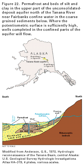
Figure 22 Cross section showing the Tanana Basin aquifer
near Fairbanks, Alaska (19K)
 editable eps file N022.eps.gz
(125K compressed)
editable eps file N022.eps.gz
(125K compressed)
Figure 23 Map showing potentiometric contours
and movement of water in the unconsolidated deposits near the
junction of the Delta and Tanana Rivers (31K)
 editable eps file N023.eps.gz
(124K compressed)
editable eps file N023.eps.gz
(124K compressed)
Figure 24 Graph showing the hydraulic connection
between the Tanana River aquifer and the Chena River near Fairbanks,
Alaska (16K)
 editable eps file N024.eps.gz
(18K compressed)
editable eps file N024.eps.gz
(18K compressed)
Figure 25 Map showing potentiometric contours
and movement of water between the Tanana and Chena Rivers (26K)
 editable eps file N025.eps.gz
(132K compressed)
editable eps file N025.eps.gz
(132K compressed)
 editable eps file N022.eps.gz
(125K compressed)
editable eps file N022.eps.gz
(125K compressed) 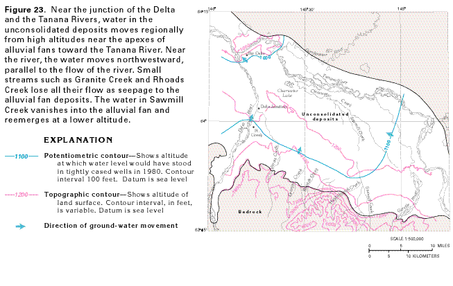 editable eps file N023.eps.gz
(124K compressed)
editable eps file N023.eps.gz
(124K compressed) 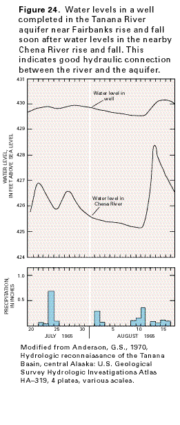 editable eps file N024.eps.gz
(18K compressed)
editable eps file N024.eps.gz
(18K compressed)  editable eps file N025.eps.gz
(132K compressed)
editable eps file N025.eps.gz
(132K compressed)