GROUND WATER ATLAS of the UNITED STATES
Alaska, Hawaii, Puerto Rico and the U. S. Virgin Islands
HA 730-N
Alaska Unconsolidated-deposit aquifers
There are two different files for each illustration
- A 72 ppi GIF file, suitable for screen viewing is accessed
through the thumbnail image.
- An eps file, suitable for downloading to be printed or edited
is accessed through the "eps file" link. Most files
are Adobe Illustrator 6.0, exceptions are noted. These files
have been compressed with GNU's gzip utility. If your web browser
defaults to a screen display of the file, turn on the "Load
to local disk" option before downloading. Download and process
these eps files as ascii, not binary.
Coastal Valley Aquifers
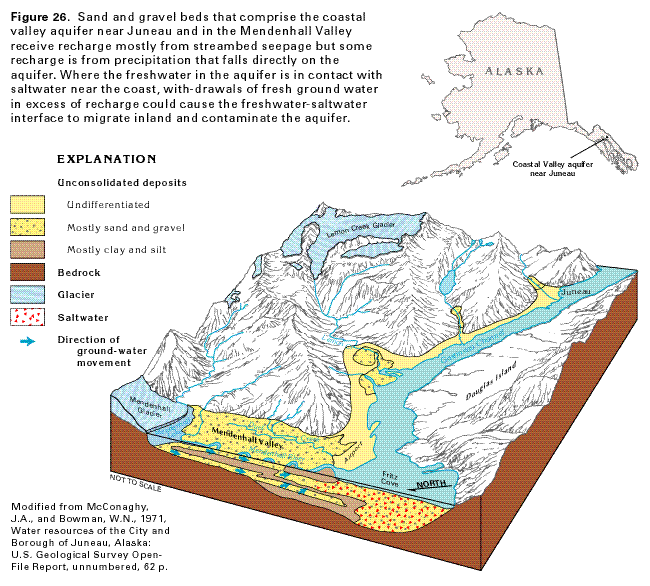
Figure 26 Diagrammatic section showing the geology of
the Coastal Valley aquifer near Juneau, Alaska (56K)
 editable eps file N026.eps.gz
(942K compressed)
editable eps file N026.eps.gz
(942K compressed)
Figure 27 Graph showing water levels in
a well completed in the upper part of the aquifer (15K)
 editable eps file N027eps.gz
(12K compressed)
editable eps file N027eps.gz
(12K compressed)
Figure 28 Cross section showing saltwater
intrusion into the unconsolidated-deposit aquifers in coastal
areas of Alaska (30K)
 editable eps file N028.eps.gz
(67K compressed)
editable eps file N028.eps.gz
(67K compressed)
 editable eps file N026.eps.gz
(942K compressed)
editable eps file N026.eps.gz
(942K compressed) 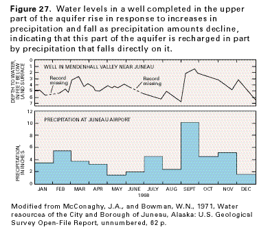 editable eps file N027eps.gz
(12K compressed)
editable eps file N027eps.gz
(12K compressed) 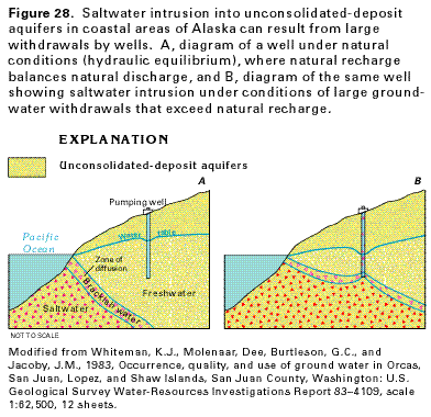 editable eps file N028.eps.gz
(67K compressed)
editable eps file N028.eps.gz
(67K compressed)