GROUND WATER ATLAS of the UNITED STATES
Alaska, Hawaii, Puerto Rico and the U. S. Virgin Islands
HA 730-N
Hawaii Oahu regional aquifer system
There are two different files for each illustration
- A 72 ppi GIF file, suitable for screen viewing is accessed
through the thumbnail image.
- An eps file, suitable for downloading to be printed or edited
is accessed through the "eps file" link. Most files
are Adobe Illustrator 6.0, exceptions are noted. These files
have been compressed with GNU's gzip utility. If your web browser
defaults to a screen display of the file, turn on the "Load
to local disk" option before downloading. Download and process
these eps files as ascii, not binary.
Oahu Regional Aquifer System
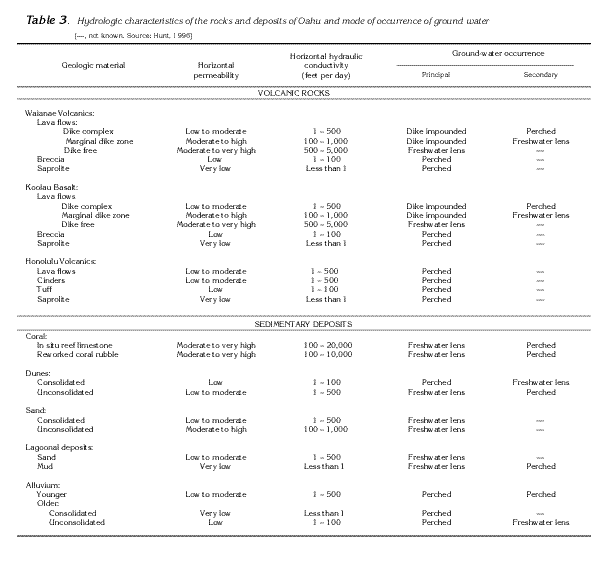
Table 3 Table showing hydrologic characteristics of
the rocks and deposits of Oahu (44K)
 editable eps file Ntab03.eps.gz
(376K compressed)
editable eps file Ntab03.eps.gz
(376K compressed)
Figure 54 Map showing calderas and rift
zones associated with the Koolau and the Waianae Volcanoes (25K)
 editable eps
file N054.eps.gz (51K compressed)
editable eps
file N054.eps.gz (51K compressed)
Figure 55 Map showing the division of Oahu
into seven major ground-water areas (26K)
 editable eps
file N055.eps.gz (38K compressed)
editable eps
file N055.eps.gz (38K compressed)
Figure 56 Map showing potentiometric contours
and water movement in Oahu (29K)
 editable eps
file N056.eps.gz (41K compressed)
editable eps
file N056.eps.gz (41K compressed)
Figure 57 Cross section showing movement
of water from high altitude areas to the Pacific Ocean (44K)
 editable eps
file N057.eps.gz (152K compressed)
editable eps
file N057.eps.gz (152K compressed)
Figure 58 Cross section showing that low-permeability
dike zones tend to impede the movement of ground water (24K)
 editable eps
file N058.eps.gz (57K compressed)
editable eps
file N058.eps.gz (57K compressed)
Figure 59 Graphs showing the lowering of
water levels in the volcanic-rock aquifer in the Pearl Harbor
area due to the large ground-water withdrawals from 1901 through
1980 (22K)
 editable eps
file N059.eps.gz (84K compressed)
editable eps
file N059.eps.gz (84K compressed)
Figure 60 Map showing predevelopment mean
annual ground-water recharge to aquifers on Oahu (25K)
 editable eps
file N060.eps.gz (32K compressed)
editable eps
file N060.eps.gz (32K compressed)
Figure 61 Graphs showing estimates of annual
ground-water withdrawals from ground-water areas on Oahu (23K)
 editable eps
file N061.eps.gz (29K compressed)
editable eps
file N061.eps.gz (29K compressed)
 editable eps file Ntab03.eps.gz
(376K compressed)
editable eps file Ntab03.eps.gz
(376K compressed) 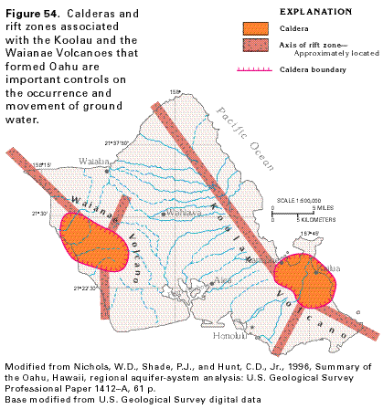 editable eps
file N054.eps.gz (51K compressed)
editable eps
file N054.eps.gz (51K compressed) 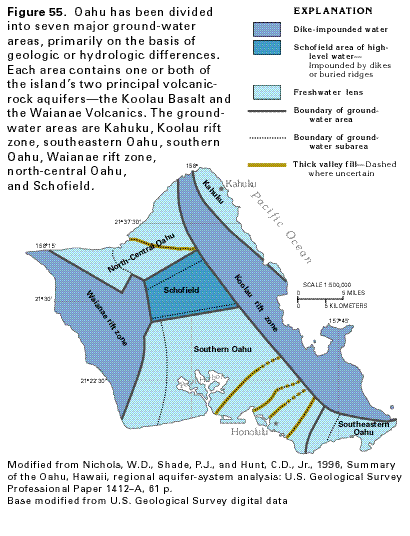 editable eps
file N055.eps.gz (38K compressed)
editable eps
file N055.eps.gz (38K compressed) 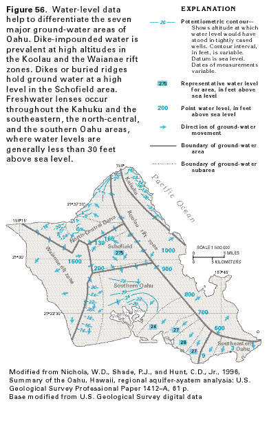 editable eps
file N056.eps.gz (41K compressed)
editable eps
file N056.eps.gz (41K compressed)  editable eps
file N057.eps.gz (152K compressed)
editable eps
file N057.eps.gz (152K compressed) 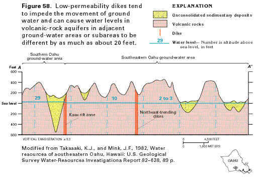 editable eps
file N058.eps.gz (57K compressed)
editable eps
file N058.eps.gz (57K compressed) 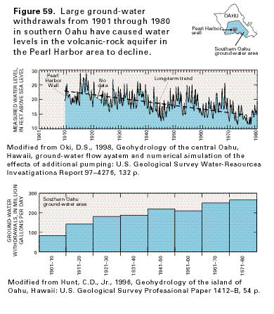 editable eps
file N059.eps.gz (84K compressed)
editable eps
file N059.eps.gz (84K compressed)  editable eps
file N060.eps.gz (32K compressed)
editable eps
file N060.eps.gz (32K compressed) 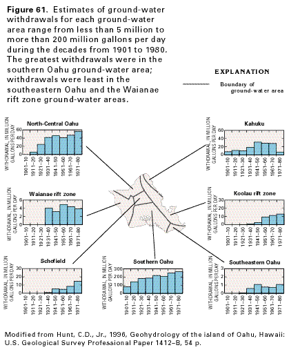 editable eps
file N061.eps.gz (29K compressed)
editable eps
file N061.eps.gz (29K compressed)