GROUND WATER ATLAS of the UNITED STATES
Alaska, Hawaii, Puerto Rico and the U. S. Virgin Islands
HA 730-N
Hawaii Ground-water problems
There are two different files for each illustration
- A 72 ppi GIF file, suitable for screen viewing is accessed
through the thumbnail image.
- An eps file, suitable for downloading to be printed or edited
is accessed through the "eps file" link. Most files
are Adobe Illustrator 6.0, exceptions are noted. These files
have been compressed with GNU's gzip utility. If your web browser
defaults to a screen display of the file, turn on the "Load
to local disk" option before downloading. Download and process
these eps files as ascii, not binary.
Ground-Water Problems
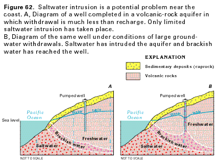
Figure 62 Cross section showing saltwater intrusion
in a freshwater aquifer (24K)
 editable eps
file N062.eps.gz (62K compressed)
editable eps
file N062.eps.gz (62K compressed)
Figure 63 Graph of a vertical salinity profile
near the Honolulu area (15K)
 editable eps
file N063.eps.gz (57K compressed)
editable eps
file N063.eps.gz (57K compressed)
Figure 64 Graphs showing relationship between
ground-water withdrawals, hydraulic head and chloride concentration
in well area near Kahuku, Oahu (25K)
 editable eps
file N064.eps.gz (27K compressed)
editable eps
file N064.eps.gz (27K compressed)
Figure 65 Diagram showing dewatering of
dike-bounded water compartments in aquifers (19K)
 editable eps
file N065.eps.gz (27K compressed)
editable eps
file N065.eps.gz (27K compressed)
 editable eps
file N062.eps.gz (62K compressed)
editable eps
file N062.eps.gz (62K compressed) 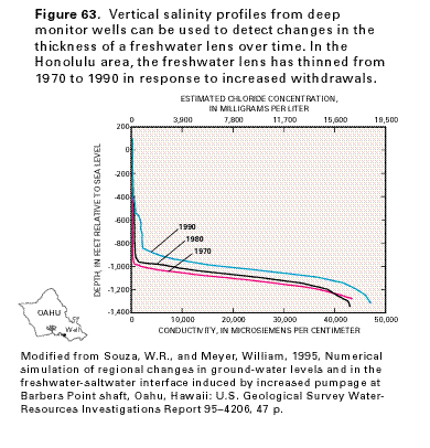 editable eps
file N063.eps.gz (57K compressed)
editable eps
file N063.eps.gz (57K compressed) 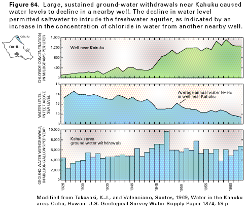 editable eps
file N064.eps.gz (27K compressed)
editable eps
file N064.eps.gz (27K compressed) 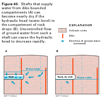 editable eps
file N065.eps.gz (27K compressed)
editable eps
file N065.eps.gz (27K compressed)