INTRODUCTION
Volcanic rocks that range in age from Miocene to Holocene are the primary rocks in the islands and are the most productive aquifers in the State of Hawaii. The rocks vary widely in origin, chemical composition, and texture and in their ability to transmit water. Volcanic-rock aquifers are found on all the islands and in some places are overlain with sedimentary deposits.
Ground-Water Occurrence and Movement
The permeability of volcanic rocks is variable and depends mainly
on the mode of emplacement of the rocks. Three main groups of
volcanic rocks exist: lava flows, dikes, and pyroclastic deposits.
Weathering reduces the permeability of all three types of volcanic
rocks. Lava flows are mainly pahoehoe (fig.
47), which has a smooth, undulating surface with a ropy appearance
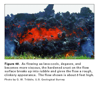
and aa (fig. 48), which has a surface
of coarse rubble (clinker) and an interior of massive rock. A
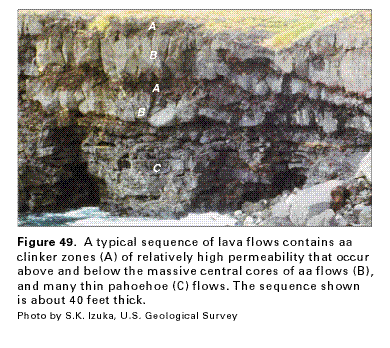
typical sequence of lava flows (fig. 49)
contains both aa and pahoehoe flows. Aa clinker zones are found
above and below the massive central core of the aa flow. Pahoehoe
flows commonly occur in a sequence of numerous thin flows. Void
spaces in a layered sequence of lava flows (fig.
50) include vesicular (gas bubbles), fracture (joints and
cracks), interflow (separations between flows), intergranular
(fragmental rock), and conduit (lava tubes) porosity. Pahoehoe
flows are fluid, flow rapidly, and tend to spread out. The void
spaces in a sequence of pahoehoe flows imparts high intrinsic
permeability. Pahoehoe lava commonly grades into aa lava with
increasing distance from the eruptive vent. The layers of clinker
at the top and bottom of aa flows commonly form productive aquifers
with permeability similar to that of coarse-grained gravel. However,
the lava in the core of an aa flow typically cools as a massive
body of rock with much lower permeability. The most productive
and most widespread aquifers consist of thick sequences of numerous
thin lava flows.
The hydraulic conductivity of an aquifer is a measure of how easily water will move through the aquifer; the higher the hydraulic conductivity, the more permeable the aquifer. In volcanic-rock aquifers composed mainly of flat-lying lava flows, the hydraulic conductivity is greatest parallel to the direction of the flows (fig. 50A), and is least perpendicular to the layered sequence of flows. On Oahu, the vertical hydraulic conductivity has been estimated to be hundreds of times less than the horizontal hydraulic conductivity. Lava tubes are extremely permeable features that can vary from less than 1 foot to more than 50 feet in diameter and can be several miles long. They form as molten lava drains out from under a solidified crust. The hydraulic conductivity of clinker zones ranges from several hundred to several thousand feet per day, which is similar to that of coarse, well-sorted gravel.
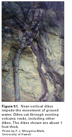
Dikes are thin, near-vertical sheets of massive, low-permeability rock that intrude existing rocks, commonly the permeable lava flows of the Hawaiian islands. Dikes (fig. 51) can extend vertically and laterally for long distances and impede the flow of ground water. Within a dike complex, dikes intersect at various angles and compartmentalize the more permeable rock in which ground water can be impounded (fig. 50B). The dikes lower overall rock porosity and permeability; the hydraulic conductivity of a dike complex can be as low as 0.01 feet per day. Dikes tend to channel ground-water flow parallel to the general trend of the dikes. In some areas, the level of dike-impounded water is much higher than that of the regional, freshwater lens.
Pyroclastic rocks include ash, cinder, spatter, and larger blocks. These deposits have hydraulic conductivity between 1 and 1,000 feet per day. Compaction and weathering can reduce the permeability; weathered ash beds commonly act as thin confining units within lava sequences.
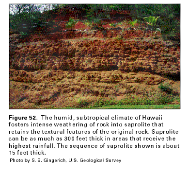
Saprolite is a soft, clay-rich, thoroughly weathered rock that has retained textural features of the parent rock (fig. 52). Exposed weathered profiles include inches to several tens of feet of saprolite. In areas of high precipitation, saprolite may be from 100 feet to as much as 300 feet thick. Rocks with a high proportion of pore space and surface area, such as ash, cinder, and aa clinker, weather preferentially; weathering of massive rock proceeds more slowly. The hydraulic conductivity of saprolite is generally less than 1 foot per day and can be as low as 0.001 foot per day.
Aquifer Extent and Characteristics
Volcanic-rock aquifers are found on all the major islands of Hawaii.
In some areas, sedimentary or pyroclastic deposits mapped at the
ground surface overlie the volcanic-rock aquifers. The areal distribution
of aquifer permeability can be depicted on a map showing the values
of specific capacity determined from short-term (less than 7 days)
aquifer tests using wells that penetrate the volcanic-rock aquifers
(fig. 53). The specific capacity of
a well is the rate of discharge of water from the well divided
by the depth that the water level in the well is lowered as the
water is withdrawn. A well with a higher specific capacity can
produce more water per foot of water-level decline, generally
indicating that the permeability of the aquifer that the well
penetrates is higher. In the Hawaiian islands, wells with the
highest specific capacities are commonly located in volcanic-rock
aquifers composed of high-permeability, dike-free, shield-building-stage
lava flows. Many of these wells are along the southern coast of
Kauai, in the Pearl Harbor area and northern coast of Oahu, and
in most of the coastal areas of Maui and the island of Hawaii.
Areas where the lava flows are intruded with dikes are less permeable
and usually contain wells with lower specific capacities. The
locations of these wells coincide with the rift zones and caldera
complexes of many of the volcanoes. In much of the eastern half
of Kauai, wells with low specific capacities are located in the
low-permeability, thick-bedded lava flows of the Koloa Volcanics.
No specific capacity values are available from wells on Niihau
or Kahoolawe.