GROUND WATER ATLAS of the UNITED STATES
Alaska, Hawaii, Puerto Rico and the U. S. Virgin Islands
HA 730-N
Puerto Rico and the U. S. Virgin Islands Kingshill aquifer
There are two different files for each illustration
- A 72 ppi GIF file, suitable for screen viewing is accessed
through the thumbnail image.
- An eps file, suitable for downloading to be printed or edited
is accessed through the "eps file" link. Most files
are Adobe Illustrator 6.0, exceptions are noted. These files
have been compressed with GNU's gzip utility. If your web browser
defaults to a screen display of the file, turn on the "Load
to local disk" option before downloading. Download and process
these eps files as ascii, not binary.
Hydrogeologic Units
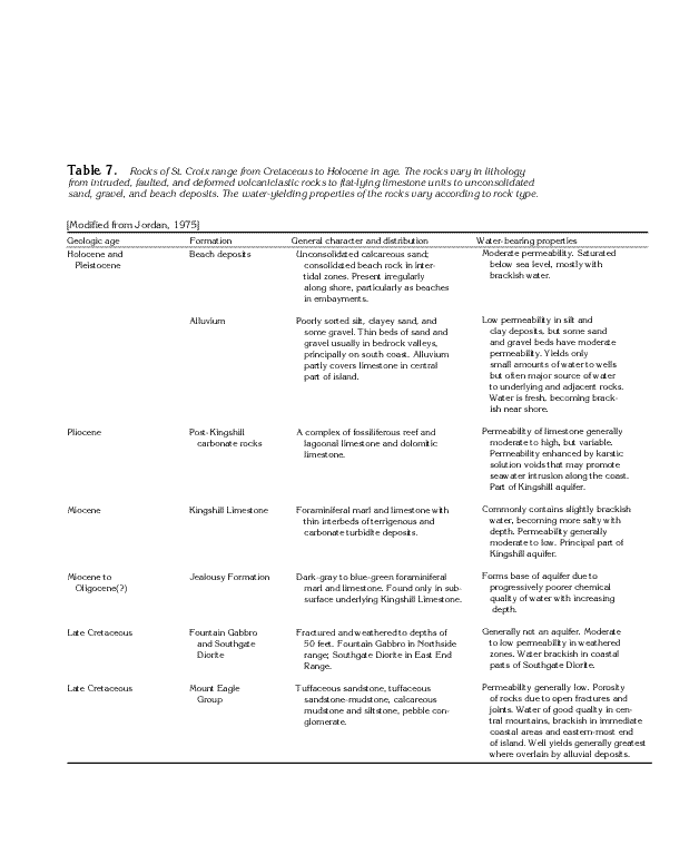
Table 7 Table showing the geological characteristics
of the Kingshill aquifer system (44K)
 editable eps file Ntab07.eps.gz
(376K compressed)
editable eps file Ntab07.eps.gz
(376K compressed)
Figure 114 Map showing the structure contour
of the top of the Jealousy Formation in the Kingshill aquifer
(14K)
 editable eps file N114.eps.gz
(30K compressed)
editable eps file N114.eps.gz
(30K compressed)
Figure 115 Map showing the variability of
the lithology of the Kingshill Limestone and post-Kingshill carbonate
rocks (13K)
 editable eps file N115.eps.gz
(28K compressed)
editable eps file N115.eps.gz
(28K compressed)
 editable eps file Ntab07.eps.gz
(376K compressed)
editable eps file Ntab07.eps.gz
(376K compressed) 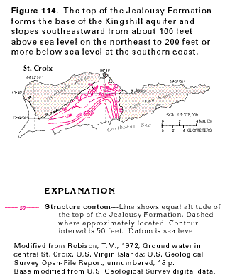 editable eps file N114.eps.gz
(30K compressed)
editable eps file N114.eps.gz
(30K compressed) 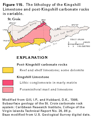 editable eps file N115.eps.gz
(28K compressed)
editable eps file N115.eps.gz
(28K compressed)