GROUND WATER ATLAS of the UNITED STATES
Alaska, Hawaii, Puerto Rico and the U. S. Virgin Islands
HA 730-N
Puerto Rico and the U. S. Virgin Islands North Coast Limestone
aquifer system
There are two different files for each illustration
- A 72 ppi GIF file, suitable for screen viewing is accessed
through the thumbnail image.
- An eps file, suitable for downloading to be printed or edited
is accessed through the "eps file" link. Most files
are Adobe Illustrator 6.0, exceptions are noted. These files
have been compressed with GNU's gzip utility. If your web browser
defaults to a screen display of the file, turn on the "Load
to local disk" option before downloading. Download and process
these eps files as ascii, not binary.
Introduction
Figure 96 Map showing the location of the North Coast
Limestone aquifer system in Puerto Rico (16K)
 editable eps file N096.eps.gz
(64K compressed)
editable eps file N096.eps.gz
(64K compressed)
Figure 97 Map showing the percentage of
karst topography in the North Coast Limestone aquifer system (32K)
 editable eps file N097.eps.gz
(180K compressed)
editable eps file N097.eps.gz
(180K compressed)
Figure 98 Photograph showing an unusual
karst feature called a conical mogote (34K)
 editable eps file N098.eps.gz
(5.4M compressed)
editable eps file N098.eps.gz
(5.4M compressed)
Figure 99 Photograph showing a common karst
feature called a sinkhole (34K)
 editable eps file N099.eps.gz
(5.6M compressed)
editable eps file N099.eps.gz
(5.6M compressed)
 editable eps file N096.eps.gz
(64K compressed)
editable eps file N096.eps.gz
(64K compressed)  editable eps file N097.eps.gz
(180K compressed)
editable eps file N097.eps.gz
(180K compressed) 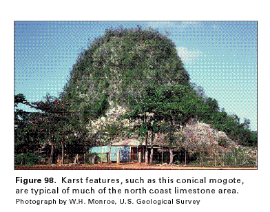 editable eps file N098.eps.gz
(5.4M compressed)
editable eps file N098.eps.gz
(5.4M compressed)  editable eps file N099.eps.gz
(5.6M compressed)
editable eps file N099.eps.gz
(5.6M compressed)