GROUND WATER ATLAS of the UNITED STATES
Alaska, Hawaii, Puerto Rico and the U. S. Virgin Islands
HA 730-N
Puerto Rico and the U. S. Virgin Islands Regional Summary
There are two different files for each illustration
- A 72 ppi GIF file, suitable for screen viewing is accessed
through the thumbnail image.
- An eps file, suitable for downloading to be printed or edited
is accessed through the "eps file" link. Most files
are Adobe Illustrator 6.0, exceptions are noted. These files
have been compressed with GNU's gzip utility. If your web browser
defaults to a screen display of the file, turn on the "Load
to local disk" option before downloading. Download and process
these eps files as ascii, not binary.
Ground-Water Quality
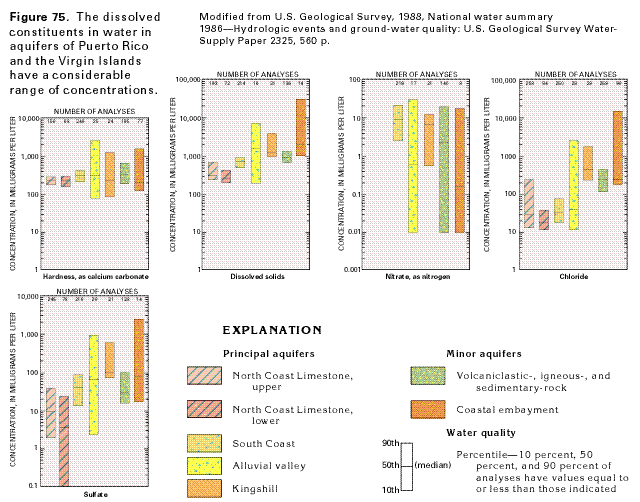
Figure 75 Graphs showing the chemical constituents in
water from aquifers of Puerto Rico and the Virgin Islands (39K)
 editable eps file N075.eps.gz
(71K compressed)
editable eps file N075.eps.gz
(71K compressed)
Figure 76 Map showing levels of dissolved-solids
concentrations in water from the North Coast Limestone aquifer
system (18K)
 editable eps file N076.eps.gz
(85K compressed)
editable eps file N076.eps.gz
(85K compressed)
Figure 77 Diagrammatic section showing the
saltwater-freshwater interface within the upper aquifer of the
North Coast Limestone aquifer system (46K)
 editable eps file N077.eps.gz
(325K compressed)
editable eps file N077.eps.gz
(325K compressed)
 editable eps file N075.eps.gz
(71K compressed)
editable eps file N075.eps.gz
(71K compressed) 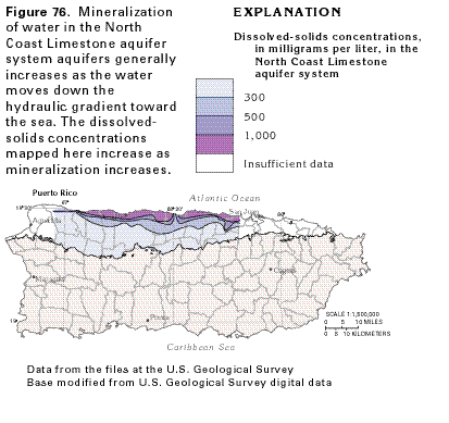 editable eps file N076.eps.gz
(85K compressed)
editable eps file N076.eps.gz
(85K compressed)  editable eps file N077.eps.gz
(325K compressed)
editable eps file N077.eps.gz
(325K compressed)