Skip Links

USGS - science for a changing world

Miscellaneous Investigations Series Map I–2005

Geologic Map of Upper Eocene to Holocene Volcanic and Related Rocks in the Cascade Range, Washington

By J.G. Smith

The digital database for this map is available as USGS Data Series 842

Thumbnail of and link to sheet 1 PDF (18.7 MB)Introduction

Since 1979 the Geothermal Research Program of the U.S. Geological Survey has carried out a multidisciplinary research effort in the Cascade Range. The goal of this research is to understand the geology, tectonics, and hydrology of the Cascades in order to characterize and quantify geothermal resource potential. A major goal of the program is compilation of a comprehensive geologic map of the entire Cascade Range that incorporates modern field studies and that has a unified and internally consistent explanation.

This map is one of a series presently being compiled that shows Cascade Range geology by fitting published and unpublished mapping into a province-wide scheme of lithostratigraphic units; map sheets of the Cascade Range in California and in Oregon complete the series. The complete series forms a guide to exploration and evaluation of the geothermal resources of the Cascade Range and will be useful for studies of volcanic hazards, volcanology, and tectonics.

For geothermal reasons, the maps emphasize Quaternary volcanic rocks. Large igneous-related geothermal systems that have high temperatures are associated with Quaternary volcanic fields, and geothermal potential declines rapidly as age increases (Smith and Shaw, 1975). Most high-grade recoverable geothermal energy is likely to be associated with silicic volcanism less than 1 Ma. Lower grade (= lower temperature) geothermal resources may be associated with somewhat older rocks; however, volcanic rocks older than about 2 Ma are unlikely geothermal targets (Smith and Shaw, 1975).

First posted October 16, 2014

The National Geologic Map Database has additional data about this publication

For additional information:
Contact CVO 
Volcano Science Center, Cascades Volcano Observatory 
U.S. Geological Survey 
1300 SE Cardinal Court, Building 10, Suite 100 
Vancouver, WA 98683-9589

Part or all of this report is presented in Portable Document Format (PDF). For best results viewing and printing PDF documents, it is recommended that you download the documents to your computer and open them with Adobe Reader. PDF documents opened from your browser may not display or print as intended. Download the latest version of Adobe Reader, free of charge.


Suggested citation:

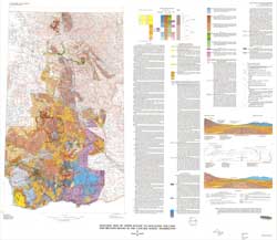
Smith, J.G., 1993, Geologic map of upper Eocene to Holocene volcanic and related rocks in the Cascade Range, Washington: Miscellaneous Investigations Series Map I-2005, 20 p., 2 sheets, https://pubs.usgs.gov/imap/2005/.


Accessibility FOIA Privacy Policies and Notices

Take Pride in America logo USA.gov logo U.S. Department of the Interior | U.S. Geological Survey
URL: http://pubsdata.usgs.gov/pubs/imap/2005/index.html
Page Contact Information: GS Pubs Web Contact
Page Last Modified: Wednesday, 30-Nov-2016 17:40:47 EST