 Abstract Abstract
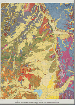
This map was first published as a printed edition in 1974. The geologic data have now been captured digitally and are presented here along with images of the printed map sheets. The map encompasses the area of four 7.5-minute quadrangles between 39º15' and 39º 30'N and 106º15' and 106º30'W in the Sawatch and Gore mountain ranges, and upper part of the Arkansas River drainage in central Colorado. The Holy Cross geologic map depicts in detail the complex geology at the north end of the Sawatch Range on the west at its junction with south end of the Gore Range on the east. The ranges are separated in the southern part of the map area by the upper reaches of the Arkansas River, and in the northeast part by the narrow valley of the upper Eagle River.
Sixty map units and numerous individual beds and thin units within the principal map units are shown. Paleoproterozoic and Mesoproterozoic metamorphic rocks are the principal rocks of the Sawatch Range. In the Gore Range, lower and upper Paleozoic sedimentary rocks rest unconformably on the Precambrian metamorphic rocks. Paleozoic rocks that range in age from Upper Cambrian though Middle Pennsylvanian support the Gore Range along the eastern quarter of the map. The sequence includes a basal quartzite overlain by interbedded, shale, dolomite, quartzite, and sandstone. The Leadville Dolomite, below the dark shale, is the host rock for the ore deposits at Leadville and the neighboring lead-zinc-silver districts. A wide range of Miocene to Cretaceous intrusive rocks dip east off the Sawatch Range. The Dry Union Formation of Pliocene and Miocene age fills the valley of the Arkansas River and is covered by Quaternary alluvium and glacial sediment. Glacial deposits of Bull Lake, Pinedale, and neoglacial age are present in many of the mountain valleys.
The geologic structure of the quadrangle is complex in geometry and time with a distinct structural and geographic break along the west front of the Gore Range in the eastern quarter of the quadrangle. In general, Paleozoic strata intruded by Tertiary and Cretaceous irregular linear plutons and sills of the Gore Range are tilted east from the Sawatch Range. These rocks are broken by major normal faults in a complex pattern commonly associated with Paleocene? and Cretaceous intrusive porphyries. In the Sawatch Range, two large Precambrian igneous complexes are separated by a broad shear zone of Precambrian age that extends northwest across the quadrangle and beneath Paleozoic rocks of the Gore Range. Down-to-valley normal faults define the margins of the Arkansas and upper Eagle River valleys.
The Leadville, Sugarloaf, and St. Kevin districts have produced significant amounts of silver. The Homestake mine at the head of West Tennessee Creek produced silver and lead from veins bearing siderite and barite. Scattered veins in shear zones along Homestake Creek are mainly argentiferous galena veins; some are quartz and copper. Veins at Holy Cross City produced gold. Other veins in the area have produced gold, silver, and minor amounts of copper.
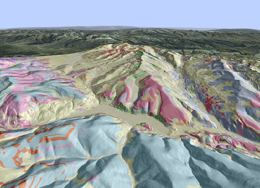
Three-dimensional shaded relief with geology of the Holy Cross 15-minute quadrangle and adjacent areas, central Colorado
|
Part or all of this report is presented in Portable Document Format (PDF); the latest version of Adobe Reader or similar software is required to view it. Download the latest version of Adobe Reader, free of charge. |

