Miscellaneous Investigations Series I-1420 (NM-16)
Abstract
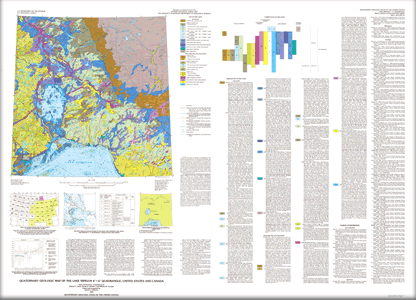
The Quaternary Geologic Map of the Lake Nipigon 4 degree x 6 degree Quadrangle was mapped as part of the Quaternary Geologic Atlas of the United States. The atlas was begun as an effort to depict the areal distribution of surficial geologic deposits and other materials that accumulated or formed during the past 2+ million years, the period that includes all activities of the human species. These materials are at the surface of the earth. They make up the "ground" on which we walk, the "dirt" in which we dig foundations, and the "soil" in which we grow crops. Most of our human activity is related in one way or another to these surface materials that are referred to collectively by many geologists as regolith, the mantle of fragmental and generally unconsolidated material that overlies the bedrock foundation of the continent. The maps were compiled at 1:1,000,000 scale. This map is a product of collaboration of the Ontario Geological Survey, the University of Michigan, and the U.S. Geological Survey, and is designed for both scientific and practical purposes. It was prepared in two stages. First, separate maps and map explanations were prepared by the compilers. Second, the maps were combined, integrated, and supplemented by the editor. Map unit symbols were revised to a uniform system of classification and the map unit descriptions were prepared by the editor from information received from the compilers and from additional sources listed under Sources of Information. Diagrams accompanying the map were prepared by the editor. For scientific purposes, the map differentiates Quaternary surficial deposits on the basis of lithology or composition, texture or particle size, structure, genesis, stratigraphic relationships, engineering geologic properties, and relative age, as shown on the correlation diagram and indicated in the map unit descriptions. Deposits of some constructional landforms, such as kame moraine deposits, are distinguished as map units. Deposits of erosional landforms, such as outwash terraces, are not distinguished, although glaciofluvial, ice-contact, and lacustrine deposits that are mapped may be terraced. As a Quaternary geologic map it serves as a base from which a variety of maps relating Quaternary geologic history can be derived. For practical purposes, the map is a surficial materials map. Materials are distinguished on the basis of lithology or composition, texture or particle size, and other physical, chemical, and engineering characteristics. It is not a map of soils that are recognized and classified in pedology or agronomy. Rather, it is a generalized map of soils as recognized in engineering geology, or of substrata or parent materials in which pedologic or agronomic soils are formed. As a materials map it serves as a base from which a variety of maps for use in planning engineering, land use, or land management projects can be derived. |
Version 1.1 Posted June 2008 |
Sado, E.V., Fullerton, D.S., and Farrand, W.R., 1994, Quaternary geologic map of the Lake Nipigon 4° x 6° quadrangle, United States and Canada: U.S. Geological Survey Miscellaneous Investigations Series Map I-1420 (NM-16), scale 1:1,000,000.

![]() U.S. Department of the Interior | U.S. Geological Survey
U.S. Department of the Interior | U.S. Geological Survey
URL: http://pubsdata.usgs.gov/pubs/imap/i-1420/nm-16/index.html
Questions or Assistance: Contact USGS
Last modified: Wednesday, 30-Nov-2016 17:34:23 EST
