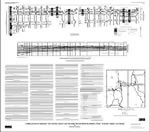
The Middle Jurassic San Rafael Group consists of
sandstone, siltstone, and shale. In
the study area, the San Rafael Group is mostly concealed
beneath younger
rocks but does crop out along Comb Ridge and in the canyon of the Dolores
River in the
western and eastern parts of the study area respectively. In an intervening
area along Montezuma
Creek, the upper part of the San Rafael Group crops out for about 10
mi; at one
locality all of the group is exposed.
In the study area, two unconformities are associated
with the rocks described herein.
The unconformities separate the San Rafael Group from the underlying
Lower Jurassic Navajo
Sandstone and the overlying Upper Jurassic Morrison Formation. The unconformities— termed J-2 at the base of the San Rafael and J-5 at the top—are
also recognized
throughout much of the Western Interior of the United States (Pipiringos
and O’Sullivan,
1978). The J-5 unconformity is the datum used to construct the line of
graphic sections and
the restored stratigraphic diagram of this report.
Version 1.0
|
| Posted November 1998 |
| Part or all of this report is presented in Portable Document Format. The latest version of Adobe Acrobat Reader or similar software is required to view it. If you wish to download the latest version of Acrobat Reader free of charge, click here.
|
|
