
U.S. Geological Survey
Geologic Investigations Series Map I-2731-A
Version 1.0
2003
By Bradford Butman, Laura Hayes, William W. Danforth, and Page C. Valentine
|
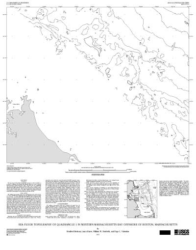
Introduction This 27 x 33 inch map shows sea floor depth as topographic contours at a scale of 1:25,000. It is based on multibeam echo-sounder data collected during four cruises conducted between the fall of 1994 and the fall of 1998. The map is part of a 3-quadrangle map series showing the area offshore of Boston, Mass., that is companion to the Stellwagen Bank National Marine Sanctuary map series (Valentine and others, 2001, 2003a-c; also see location map). Other maps of Quadrangle 1 depict shaded relief and topographic contours (Butman and others, 2003a), and backscatter intensity, shaded relief, and topographic contours (Butman and others, 2003b). |
 |
| Thumbnail image of map I-2731-A |
Geologic Investigations Series Map I-2731-A [180-KB PDF file]
Download free Adobe Reader software.
Visit the Adobe accessibility website.
Contact Information
For questions about the scientific content of this report, contact Bradford Butman.
[an error occurred while processing this directive]