
U.S. Geological Survey
Miscellaneous Investigations Series Map I-1311
version 1.0
U.S.
Geological Survey
Miscellaneous Investigations Series Map I-1311
version 1.0
Geologic Map of the Wenatchee 1:100,000 Quadrangle, Central Washington
By R.W. Tabor, R.B. Waitt, V.A. Frizzell, Jr., D.A. Swanson, G.R. Byerly, and R.D. Bentley
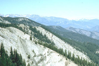 |
| Sandstone beds of Chumstick Formation cut by basalt dikes. Looking north across upper Devils Canyon. Most hills in the middle ground are within the Chiwaukum "graben". High peaks on the left are carved from the Mount Stuart batholith and rocks of the Ingalls Tectonic Complex. Distant high peaks on the right are carved from metamorphic rocks of the Northern Entiat Mountains. |
| The rocks and deposits within the Wenatchee quadrangle can be grouped into six generalized units: (1) Precambrian(?) Swakane Biotite Gneiss in the northeastern part of the quadrangle and the probable Jurassic low-grade metamorphic suite, mostly composed of the Easton Schist, in the southwestern part; (2) the Mesozoic Ingalls Tectonic Complex; (3) the Mesozoic Mount Stuart batholith; (4) lower and middle Tertiary nonmarine sedimentary and volcanic rocks; (5) Miocene basalt flows and interbedded epiclastic rocks constituting part of the Columbia River Basalt Group and interbedded silicic volcaniclastic rocks of the Ellensburg Formation; and (6) Pliocene to Holocene alluvium, glacial, flood, and mass-wastage deposits. |
Download this map as a PDF file; includes correlation of map units and Table 1-samples dataed by fission-track and isotope analysis (wengmp.pdf; 7.6 MB)
Download the description of map units as a PDF file (wenDMU.pdf; 96 KB)
Download the accompanying pamphlet as a PDF file (wenpama.pdf; 760 KB)
Go to the digital data publication for this map, USGS Data Series 137
For questions about the content of this report, contact Rowland Tabor
Download the Version history
Download a free copy of Adobe Reader to view the PDFs
| Help | PDF help | Geopubs main page | I-map |
This map and the accompanying pamphlet are also available from:
USGS Information
Services, Box 25286,
Federal Center, Denver, CO 80225
telephone: 303-202-4210; e-mail: [email protected]
| Department of the Interior | U.S. Geological Survey | Geologic Division | Western Earth Surface Processes |