U.S. Geological Survey Miscellaneous Investigations Series Map I-1885
Summary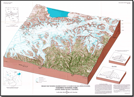
This map shows the alpine ice field and associated valley glaciers at their maximum extent during the Tioga glaciation. The Tioga glaciation, which peaked about 15,000-20,OOO years ago, was the last major glaciation in the Sierra Nevada. The Tuolumne ice field fed not only the trunk glacier that moved down the Tuolumne River canyon through the present-day Hetch Hetchy Reservoir, but it also overflowed major ridge crests into many adjoining drainage systems. Some of the ice flowed over low passes to augment the flows moving from the Merced basin down through little Yosemite Valley. Tuolumne ice flowed southwest down the Tuolumne River into the Tenaya Lake basin and then down Tenaya Canyon to join the Merced glacier in Yosemite Valley. During the Tioga glaciation, the glacier in Yosemite Valley reached only as far as Bridalveil Meadow, although during a much earlier glaciation, a glacier extended about 10 miles farther down the Merced River to the vicinity of El Portal. Ice of the Tioga glaciation also flowed eastward from the summit region to cascade down the canyons that cut into the eastern escarpment of the Sierra Nevada [see errata, below]. Southeast of the present-day Yosemite Park, glaciers formed in the Mount Lyell region flowed east onto the Mono lowland and southeast and south down the Middle and North Forks of the San Joaquin River. In the southern part of the park, glaciers nearly reached to the present-day site of Wawona along the South Fork of the Merced River. At the time of the maximum extent of the Tioga glaciation, Lake Russell (Pleistocene Mono Lake) had a surface elevation of 6,800 feet, 425 feet higher than the 1980 elevation and 400 feet lower than its maximum level at the end of the Tioga glaciation. Only a few volcanic domes of the Mono Craters existed at the time of the Tioga glaciation. <.p> The distribution of vegetation, as suggested by the green overprint, is based on our interpretation. Forests were restricted to lower elevations than present day, but alpine plant species probably thrived where snow was seasonal, much as they occur today. ErratumThe branching arrow on the map showing ice flowing from the basin east of Kuna Crest both northeastward around Mount Dana into the Mono Lake drainage and westward to the Tuolumne River is in error. No ice flowed northeastward from this basin through the site of Tioga Pass into the Mono Lake drainage. Although such an interpretation might be possible on the basis oJ the estimated elevation of the ice surface, the field evidence does not support it. A large and persistent boulder train of metamorphic rocks derived from Mount Dana and the mountain (Mount Gibbs) immediately to the south of Mount Dana has been mapped from near the base of Mount Dana westward toward the ice-filled gorge between Pettit Peak and Double Rock (the present Grand Canyon of the Tuolumne), indicating that ice from the west flank of Mount Dana flowed westward down the Tuolumne. In addition, glacial erratics of Cathedral Peak Granodiorite were observed near Tioga Pass (near the head of the erroneous arrow between Mount Dana and Mount Conness). These boulders must have come from the east face of Mount Conness or the mountain south of Mount Conness (White Mountain) and been transported by ice' flowing toward the Tioga Pass area, although the main mass of that ice turned eastward and flowed into the Mono Lake drainage. Tioga Pass was then the site of more-or-less stagnant ice between the Tuolumne drainage and that east of Mount Conness. Both the metamorphic boulder train and the glacial erratics of Cathedral Peak Granodiorite are incompatible with any flow of ice northeastward from the basin east of Kuna Crest into the Mono Lake drainage north of Mount Dana. |
For additional information: This report is presented in Portable Document Format (PDF); the latest version of Adobe Reader or similar software is required to view it. Download the latest version of Adobe Reader, free of charge. |
Alpha, Tau Rho, Wahrhaftig, Clyde, and Huber, N. King, 1987, Oblique map showing maximum extent of 20,000-year-old (Tioga) glaciers, Yosemite National Park, central Sierra Nevada, California: U.S. Geological Survey Miscellaneous Investigations Series Map I-1885.

![]() U.S. Department of the Interior |
U.S. Geological Survey
U.S. Department of the Interior |
U.S. Geological Survey
URL: http://
pubsdata.usgs.gov
/pubs/imap/i1885/index.html
Page Contact Information: USGS Publications Team
Page Last Modified: Wednesday, 30-Nov-2016 17:39:47 EST
