with accompanying pamphlet
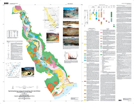
The Lonely Dell reach of the Paria River is in the lower Paria Canyon, a colorful relatively open valley eroded into the Moenkopi Formation (Triassic). The valley lies nearly 600 m below the Echo Cliffs on the east and 900 m below the Paria Plateau on the west. Paria Canyon is a strike valley aligned with the Echo Cliffs monocline, a major northwest trending flexure with more than 1 km of uplift. The Paria River, a perennial stream, joins the Colorado River downstream of Lees Ferry, which is near the beginning of the Grand Canyon of the Colorado River. This large-scale surficial geologic map shows the age, distribution, and origin of Quaternary deposits in the river valley. Information about recent geologic activity is necessary to understand the natural variability of the river system as well as the rates, magnitudes, and processes of environmental change. The alluvial history of the past thousand years is of particular interest as it relates to how the climate of the Medieval Warm Period (ca. 1000-1400), the Little Ice Age (1400 to the middle- to late 1800s), and recent global warming (late 1800s to present) affected the alluvial system. This history provides clues about how the Paria River, and others like it, may respond to future climate variation brought about by increasing concentrations of greenhouse gasses. The alluvial history of the Paria River is especially important as a research topic because of the long, continuous record of streamflow measurements. Beginning in 1923, this record is the longest of any stream originating on the Colorado Plateau. The long-term streamflow patterns at the Paria and Colorado River gaging stations reveal environmental changes of the 20th century, including arroyo cutting, droughts, and floods. The Lees Ferry/Lonely Dell area has a long and rich cultural history. The area has been an important Colorado River crossing since prehistoric times. It is the only accessible ford of the Colorado River between two virtually uncrossable canyons, Glen Canyon and Marble Canyon. The first written description of the area is the Dominguez-Escalante Journal, an account of an expedition through the Southwest in 1776. The expedition camped on the banks of the Paria River below Lees Lookout from October 27 to November 1, 1776, while trying unsuccessfully to cross the Colorado River. They left the area via Sand Pass Trail and forded the Colorado River at Crossing of the Fathers, 40 km northeast of the study area. As they rode north up the Paria River valley, they passed over what is now the settlement terrace. Almost a century later, the area was visited and described by John Wesley Powell during his explorations of the Colorado River. In late 1871, the ferry and Lonely Dell Ranch were established by John D. Lee. Because of its regional importance as a river crossing, its spectacular scenery, and the presence of two stream gaging stations, the area has been photographed numerous times beginning in 1872. These photographs are reproduced and interpreted in the accompanying pamphlet by R.H. Webb and Richard Hereford. The photographs show clearly that the channels of the Paria and Colorado Rivers have changed substantially in the intervening 123 years. In modern times, the area is important for recreation including sightseeing, hiking, and fishing, and as a launching point for whitewater raft trips through Grand Canyon. |
| File
Name |
File
Type and Description |
File
Size |
| | ||
| FILES for VIEWING and PLOTTING |
||
| PDF file of the 25-page pamphlet of comparative landscape photographs that accompanies the map | 13 MB |
|
| PDF file of 51" x 40" map sheet that can be used for viewing map in a browser, as well as for plotting (geologic map, description of map units, correlation of map units, and photographs) | 1.8
MB |
|
For questions about the content of this report, contact Richard Hereford
Download a current version of Acrobat Reader for free
| Help
| PDF help
| Western reports main page |
| Western Geologic and Miscellaneous Investigation Series Maps |
| Privacy
Statement | Disclaimer
| Accessibility |
| Geologic
Division | Water Resources National Research Program
|
This report is also available from:
USGS Information Services, Box 25286,
Federal Center, Denver, CO 80225
telephone: 303-202-4210; e-mail: infoservices@usgs.gov