
U.S. Geological Survey Geologic Investigation Series I-2775
Published 2003 - Online Version 1.0
Geology of the Fremont Quadrangle, Shannon, Carter, and Oregon Counties, Missouri
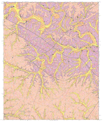
Above: Thumbnail image of the geologic map of the Fremont quadrangle
(Detailed graphics files available for download below). .
|
Abstract This map is one of several being produced under the U.S. Geological Survey National Cooperative Geologic Mapping Program to provide geologic data applicable to land-use problems in the Ozarks of south-central Missouri. Ongoing and potential industrial and agricultural development in the Ozarks region has presented issues of ground-water quality in karst areas. National Park in this region (Ozark National Scenic Riverways, Missouri) is concerned about the effects of activities in areas outside of their stewardship on the water resources that define the heart of this Park. This task applies geologic mapping and karst investigations to address issues surrounding competing land use in south-central Missouri. This task keeps geologists from the USGS associated with the park and allows the Parks to utilize USGS expertise and aid the NPS on how to effectively use geologic maps for Park management. For more information see: http://geology.er.usgs.gov/eespteam/Karst/ |
Data Available in this Report
 Geology
of the Fremont quadrangle map – Complete
Geologic Investigations Series I–2775 map plate (Orndorff, 2003: zipped
PDF format, 7.37 MB) README file with file structure of data and other miscellaneous information (.txt format) GIS data:
Geology
of the Fremont quadrangle map – Complete
Geologic Investigations Series I–2775 map plate (Orndorff, 2003: zipped
PDF format, 7.37 MB) README file with file structure of data and other miscellaneous information (.txt format) GIS data:
Direct questions and comments to:
David J. Weary
U.S. Geological Survey
Email to: dweary@usgs.gov
Phone (703)-648-6113
U.S. Department of the Interior, U.S. Geological Survey
URL: https://pubsdata.usgs.gov/pubs/imap/i2775/index.html
Maintained by Eastern Publications Group
Last modified: 17:38:36 Wed 30 Nov 2016
Privacy statement | General disclaimer | Accessibility