|
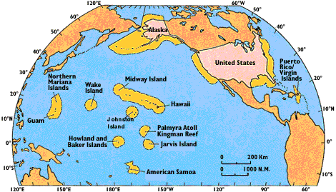
| Figure 1. Exclusive Economic Zone (EEZ) of the United States and its affiliated islands is shown in yellow. The EEZ is larger than the land area of the United States. From McGregor and Lockwood (1985). |
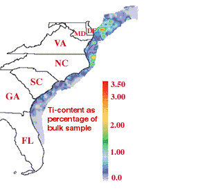
Studies suggest that the EEZ contains substantial mineral resources, including industrial minerals like ilmenite (a source of titanium, Ti) and monazite (a source of thorium and rare earth elements), as well as gold and platinum, which are sometimes associated with them. Ilmenite distribution off the East Coast of the United States is shown in figure 2.
|
Figure 2. Ilmenite (FeTiO3) detected in very limited sampling from ships off the East Coast of the United States; the colors indicate Ti contents in Vibracore samples. From Andrew Grosz (unpub. data, 1997). |
Vast amounts of urban waste have been dumped offshore (for instance, offshore Miami, in the New York Bight, Long Island Sound, and Boston Harbor). These sea-floor waste deposits are significant health and even navigation hazards, and they are being mobilized by ocean currents. The hypodermic needles that washed ashore on the New Jersey coast several years ago came from the New York municipal waste barges that have operated in the New York Bight over the past several decades.
In addition to urban waste dumps, there are numerous places where unexploded ordnance (UXO) has been left over from World War II and peacetime military exercises. This UXO is generally buried beneath a shallow layer of sediments and is invisible. It poses a threat to divers, marine life, and fishermen.
Several approaches have been taken to characterize and map the mineral resources and hazards of the EEZ. Sidescan-sonar and high-frequency seismic-reflection ("chirp") methods can be used to identify shapes and features on the sea floor. Scientists have learned to correlate data from these methods with ancient beach deposits and, in places, with modern dump sites.
|
Sidescan-sonar images, however, can only identify shapes, and then only on a very gross scale; they cannot, for instance, directly identify mineral deposits or UXO. Grab-sampling and Vibracoring (where a plastic tube is vibrated into the sea floor to recover a vertical section of sediments; see figure 3) can sample the sea floor, but both techniques provide only point data, are labor intensive, and are very expensive. It became apparent that we needed something that could map large tracts of the bottom sediments down to at least 20 feet (6 meters) below the sea floor (the typical depth limit of a Vibracore) and directly detect different minerals and metals in very small concentrations. Experiments indicate that induced polarization surveys of the nearshore sea floor are a promising approach. |
The IP method can detect pyrite (iron sulfide often called "fool's gold") in minute quantities, sometimes as low as 0.1-0.2 percent. In the early 1970's, a variant of this IP method called "complex resistivity" or "spectral IP" was developed. Instead of measuring just one or two physical parameters (for example, resistivity and phase shift) at a single frequency, this approach measures both resistivity and phase shift (also sometimes called the "chargeability") over a wide range of frequencies. With this wide spectral range, we can plot the behavior of the IP effect (the complex resistivity) on a graph of magnitude vs. phase and see distinct "signatures" for different mineral assemblages. Until the mid-1980's, however, the IP method had never been tried at sea because of the high conductivity of seawater and engineering difficulties in controlling noise in the signal.
Since about 9,000-10,000 years ago, seawater levels worldwide have risen as the glaciers retreated northward in the northern hemisphere. Relatively recent, titanium-rich beach deposits are known to exist as far as 30 miles (50 km) off the coast of Georgia. Similar deposits off the coast of Sierra Leone are known to also host rich platinum resources. This is because platinum-group elements and ilmenite (and also gold) are frequently found in similar rocks, are eroded at the same time, and tend to be transported in a similar way.

|
| Figure 4. A schematic diagram of the marine induced-polarization (IP) streamer being towed. Note that there are two different receiver electrode pairs (1-3 and 2-4). Pair 1-3 is designed for shallow (up to 6 feet or 2 meters) detection, and pair 2-4 is for deeper (up to 20 feet or 6 meters) depths into the underlying sediments. |
|
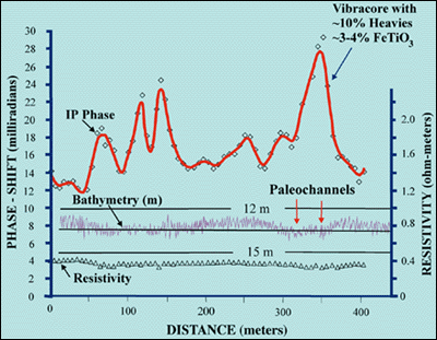
| Figure 5. An example of marine induced-polarization (IP) data acquired with a prototype streamer off the Georgia coast. Note the IP peak over paleochannels in the sea floor observed in the bathymetry (in meters). A Vibracore collected nearby contained as much as 10 percent heavy minerals, including 4 percent ilmenite (Wynn, 1988). |
These prototype experiments demonstrated that marine IP is a practical approach for mapping heavy minerals (including ilmenite) in the shallow offshore environment. Experiments with the spectral IP technique (where the IP effect is measured as both magnitude and phase shifts over a frequency range of 0.1-100 hertz) gave ambiguous results. This was because spectral IP measurements can be made only by using a stationary (not moving) streamer. Because of limitations with the navigation equipment available at the time (LORAN), we were unable to precisely reoccupy locations of some mineral-loaded Vibracores, or even to reoccupy with sufficient precision some of our towed-mode IP "hits." Examples of ilmenite-bearing deposits mapped nearby onshore are usually highly localized, typically being 65 feet (20 meters) wide by 1,600 feet (500 meters) long.
Project goals include development of a geophysical and geologic toolkit for identifying and quantifying industrial mineral concentrations, UXO waste dumping materials, construction aggregate and beach-reclamation resources, and beach-reclamation sediments on the shallow offshore continental shelves of the United States. As this handout was assembled, no actual marine IP experiments had yet been conducted offshore in the search for UXO or urban waste, though IP had been proven effective for these targets on land.
The primary tool for this project, as outlined above, is a USGS-developed marine induced-polarization technology. We initially developed this new electrical streamer system to directly detect placer heavy minerals, certain clays, and disseminated metals directly on the sea floor from a moving vessel. We realize that it also can provide porosity information about layered sediments. During our surveys, we also acquire precise GPS (Global Positioning System) location information and integrate the two. Subsequent evolutions of the IP streamer system will also incorporate bathymetry. Additional tools that may be used include the following:
We also anticipate future cooperation with other interested agencies and organizations. We propose to expand applications of the marine streamer system to resource data gathering in near-offshore shelf areas of both the east and west coasts of the continental United States and to Alaska and Puerto Rico, targeting not only heavy-mineral resources, but also waste-dumping sites and potentially even UXO.
|
U.S. Department of the Interior U.S. Geological Survey |
USGS Information Handout April 1998 |