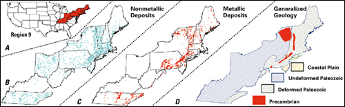
Region 9This report provides an overview of data being collected in Region 9, which contains 13 States (fig. 1A) -- Maine, Vermont, New Hampshire, Massachusetts, Connecticut, Rhode Island, New York, New Jersey, Pennsylvania, Ohio, West Virginia, Kentucky, and Tennessee. Region 9 contains some of the most productive and intensively mined lands in the Nation (table 1). This production comes from the over 4,500 nonmetallic deposits and the approximately 2,500 metallic deposits shown in figures 1B and C. |
|
Geologic data.--Geology generally is the most important factor controlling the distribution and character of ore deposits. This control is evidenced in figure 1 by the coincidence of metallic deposits (fig. 1C) and bedrock that is either old (Precambrian age) or extensively deformed (fig. 1D). In contrast, surficial or nonbedrock geologic features control the occurrence of many nonmetallic deposits; the density of identified nonmetallic deposits (fig. 1B) tends to be greatest along the densely populated eastern seaboard, the region where urban growth causes demand for the nonmetallic commodities to be greatest.
|
| Figure 1. Maps showing (A) location of Region 9 States (red), (B) distribution of nonmetallic deposits in Region 9, (C) distribution of metallic deposits in Region 9, and (D) generalized bedrock geology of Region 9. |
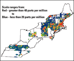
Geochemical data.--Chemical analysis of rocks, soils, and stream sediments can be used to define the Earthąs composition. In Region 9, the best available data are from the chemical analyses of stream sediments that were done during the National Uranium Resource Evaluation (NURE) Program. These data were used to make figure 2, which shows variations in lead concentrations within Region 9. The map shows both systematic regional variations in the amount of lead and the imperfect coverage of data. Variations in lead concentrations may reflect the occurrence of different rock types, anomalies associated with lead-bearing deposits, or contamination. They do provide important information about the possible locations of undiscovered deposits.
|
|
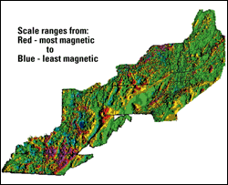
Geophysical data.--Geophysical tools measure the physical properties of the Earth. Often these can be directly related to geology and can provide important information in areas where rocks are poorly exposed. The generalized aeromagnetic map of Region 9 (fig. 3) provides such information and is particularly useful in locating structures that might have acted to localize mineralization.
Mineral deposit data.--Mineral deposits generally occur in mineral districts that are associated with broad geological features. Therefore, the distribution of known mineral deposits and occurrences can be used to predict where undiscovered deposits might be found. The principal source of these data is the USGS Mineral Resources Data System (MRDS), which provided the information used to make the maps shown in figures 1B and 1C.
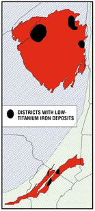
An important aspect of working with this deposit information is the grouping of deposits that have similar developmental characteristics. As an example, a subset of the MRDS data is iron deposits in which the ore mineral (magnetite) contains low concentrations of titanium. These deposits occur in districts within old (Precambrian) rocks in parts of New York and New Jersey (fig. 4). It is now thought that these deposits formed by processes similar to those that are responsible for producing some of the world's largest concentrations of copper, uranium, and rare earth elements. Significant concentrations of these elements have not been recognized in New York and New Jersey, but the presence of the low-titanium iron deposits suggests that they might be present.
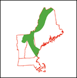
The AssessmentThe assessment integrates these diverse data sets to estimate the size, quality, and location of undiscovered mineral deposits. The process involves three steps. First, geologic and other related data sets are used to identify areas that are either permissive or favorable for undiscovered mineral deposits. As an example, figure 5 shows areas in Region 9 that are permissive for a specific kind of copper deposit (deposits that occur in association with a class of igneous intrusions called porphyries). Second, estimates are made of the number of undiscovered deposits within each of these tracts. Third, additional estimates are developed giving the ranges of possible tonnages and grades of deposits within each tract. The combination of these estimates results in a regional mineral resource assessment. |
| ||
|
|||
|
For more information, please contact:
Michael P. Foose |
|
|
U.S. Geological Survey 954 National Center Reston, VA 20192 |
Telephone: (703) 6486333 Fax: (703) 6486383 E-mail: mfoose@usgs.gov |
|
U.S. Department of the Interior U.S. Geological Survey |
USGS Information Handout May 1998 |