
|
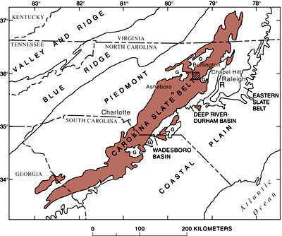
Figure 1. Location of the Carolina slate belt and the area illustrated in figure 3 (striped box). G, granitic bedrock. From Williams, R.S., Jr., and Kover, A.N., 1978, Remote sensing: Geotimes, v. 23, no. 1, p. 43-45. |
Field studies established that the forest community growing in these areas is dominated by Quercus prinus (chestnut oak); subordinate species include Pinus virginiana (Virginia pine) and Acer rubrum (red maple). The understory is typically open, with patches of Vaccinium sp. (blueberry). Because the siliceous bedrock resists erosion, chestnut-oak forest occurs on topographically high knobs and ridges, outcrops are typically abundant, and the soil horizon is relatively thin. The chestnut-oak forest contrasts with the typical mixed deciduous forest in the slate belt, which has many more species, healthier trees, and denser understory. An important limitation of the Landsat data analysis is the inability to separate chestnut-oak communities growing on unaltered silicic volcanic rocks, which have not yielded mineral deposits, from those growing on altered rocks that host important nonmetallic deposits, as well as gold deposits. Consequently, a means of distinguishing chestnut-oak forest growing on these different substrates would be quite useful for mineral assessment in the Carolina slate belt, and development of such a technique should lead to similar applications in other heavily vegetated regions.
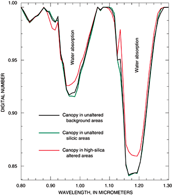
Preliminary analysis of calibrated AVIRIS data recorded on June 26, 1996, indicates that chestnut-oak forests growing on high-silica altered rocks are spectrally distinct from chestnut-oak forests growing on most unaltered silicic volcanic rocks, as well as forests growing on unaltered rock units. The dominant spectral features in forest canopies are related to chlorophyll absorption, which causes their green color in the visible part of the solar spectrum, and to water absorption, which dominates the near-infrared part of the spectrum. The intensity of water absorption by the chestnut-oak forest canopy growing in silicified altered areas is weaker than the intensity measured by AVIRIS in forest canopies growing above unaltered silicic volcanic rocks and in the background canopy (fig. 2). Analysis of soil samples shows that the nutrient content and moisture retention capacity are lower in the soils derived from the high-silica altered rocks. These deficiencies result in the growth of chestnut-forest canopies on the altered sites; these canopies are slightly more sparse than the normal background canopy and are expressed in the AVIRIS data by lower water absorption.
|
Figure 2. AVIRIS spectra showing lower intensity of water absorption in the anomalous canopy of chestnut-oak forest growing above high-silica altered rocks (red line) compared with intensity in the canopy developed in areas underlain by unaltered silicic volcanic rocks (green line) and in the background canopy common to other areas of unaltered rocks (black line). |
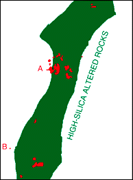
Figure 3 illustrates how information about the distribution of chestnut-oak forest can be used to improve geologic mapping and mineral and geoenvironmental assessments in the slate belt. A previously mapped zone of localized occurrences of high-silica altered rocks is shown in green, and areas of chestnut-oak forests mapped by using AVIRIS data are shown in red. Points A and B indicate areas where high-silica altered rocks were mapped outside the green map zone by using AVIRIS data. Field examination of the red areas confirmed the need to expand the green zone westward to encompass areas A and B. The sporadic distribution of chestnut-oak areas within the mapped zone of altered rocks is due to the localized nature of this type of alteration and to the incomplete forest cover resulting from cutting of the forest.
|
Figure 3. Zone of silicified altered rocks (green) and the distribution of chestnut-oak forest mapped by using AVIRIS data (red). Points A and B indicate areas of chestnut-oak forest and silicified altered rocks that lie outside the mapped zone of altered rocks (green). Location of zone shown in figure 1. |
These results show the potential for using remote sensing, especially high-spectral-resolution, AVIRIS-type data, for improving the accuracy of mineral resource assessment in regions similar to the Carolina slate belt. The usefulness of this technique will increase as the data are collected by satellite-borne imaging systems because the measurements can be made during times of good weather conditions and during different seasons of the year.
|
For more information, please contact:
Lawrence C. Rowan |
|
|
954 National Center Reston, VA 20192 |
Telephone: (703) 648-6381 E-mail: lrowan@usgs.gov |
|
U.S. Department of the Interior U.S. Geological Survey |
USGS Information Handout August 1998 |