U.S. Geological Survey Miscellaneous Field Studies Map 2329
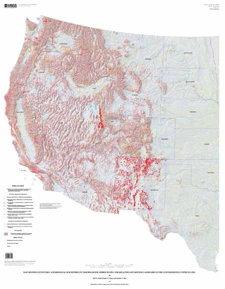
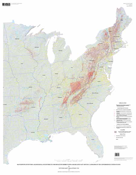
Debris flows, debris avalanches, mud flows and lahars are fast-moving landslides that occur in a wide variety of environments throughout the world. They are particularly dangerous to life and property because they move quickly, destroy objects in their paths, and often strike without warning. This map represents a significant effort to compile the locations of known debris flows in United Stated and predict where future flows might occur.
The files "dfipoint.e00" and "dfipoly.e00" contain the locations of over 6600 debris flows from published and unpublished sources. The locations are referenced by numbers that correspond to entries in a bibliography, which is part of the pamphlet "mf2329_pamphlet.pdf". The areas of possible future debris flows are shown in the file "susceptibility.tif", which is a georeferenced TIFF file that can be opened in an image editing program or imported into a GIS system like ARC/INFO. All other databases are in ARC/INFO export (.e00) format.
Files available for download include 2 map sheets, a 42-page explanatory pamphlet, and a spatial database. The entire publication can be downloaded from this site.
mf2329_sheet1.pdf PDF version of sheet 1, useful for viewing the map on a computer. File can be printed on a large plotter (6.6 MB).
mf2329_sheet2.pdf PDF version of sheet 2, useful for viewing the map on a computer. File can be printed on a large plotter (6.5 MB).
mf2329_pamphlet.pdf PDF version of accompanying pamphlet for map (149 kb).
sheet1mf2329.ps PostScript file showing western half of the United States, useful for printing on large-scale plotters (91 MB).sheet2mf2329.ps PostScript file showing eastern half of the United States, useful for printing on large-scale plotters (88 MB).
mf2329text.docx MS Word .docx (XML-based) version of pamphlet (101 kb).
readme.txt Explains the purpose of each file below, includes the same information as on this page (1 kb).
Debris Flow Information
susceptibility.tif Debris flow susceptibility/shaded relief map (85 MB).
susceptibility.tfw World file for susceptibility/shaded relief map (1 kb).
dfipoint.e00 Debris flow inventory points (1 MB).
dfipoly.e00 Debris flow inventory polygons (448 kb).
debrisflow.zip All four of the above files in a .zip archive (3.6 MB).
Note: The debris flow locations were plotted on these base maps to make the final version of the map. They are also available from the online National Atlas of the United States, http://www.nationalatlas.gov
Base Maps
state.e00 State boundaries; 1,200,000 scale from National Atlas (1 MB).
statename.e00 State names (52 kb).
county.e00 County boundaries; 1,200,000 scale from National Atlas (4 MB).
countyname.e00 County names (4 MB).
hydro.e00 Water bodies; 1,200,000 scale from National Atlas (55 MB).
basemaps.zip All five of the above files in a .zip archive (18.4 MB).
Note: For ARC/INFO users, the AML code and files used to generate the final map sheets are also included here so you can see how the postscript files were made. You will need all the files below as well as the base maps if you want to use these files to generate your own plot files, and you will be required to edit the AML code to ensure it has the correct filenames/paths for your files. If all you want is a copy of one of the map sheets, it is much faster to just download the PDF.
Plot AMLs and Related Files
sheet1.aml Plot aml for sheet 1 (western half of US) (14 kb).
sheet2.aml Plot aml for sheet 2 (eastern half of US) (14 kb).
basecredit.txt Required by plot amls (basemap credits) (1 kb).
usgs.txt Required by plot amls ( 1 kb).
imap.txt Required by plot amls (1 kb).
imap2.txt Required by plot amls (1 kb).
joescale.eps Required by plot amls (bar scale) (152 kb).
sht1-mask.e00 Required by plot amls (mask coverage) (871 kb)>
sht2-mask.e00 Required by plot amls (mask coverage) (3 MB).
sht2-maks2.e00 Required by plot amls (mask coverage) (8 kb).
aml.zip All ten of the above files in a .zip archive (1.2 MB).
FDGC-Compliant Metadata
dfi-grid.met.txt Metadata for raster data layer (15 kb).
dfi-covers.met.txt Metadata for vector data layer (161 kb).For questions about the scientific content of this report, please contact Earl Brabb
For questions about the digital database, please contact Joe Colgan
For additional information:
Contact Information, Western Region Geology and Geophysics Science Center—Menlo Park
U.S. Geological Survey
345 Middlefield Road, MS-973
Menlo Park, CA 94025-3591
http://geomaps.wr.usgs.gov/
Earl E. Brabb, Joseph P. Colgan, and Timothy C. Best, 1999, Map Showing Inventory and Regional Susceptibility for Holocene Debris Flows, and Related Fast-Moving Landslides in the Conterminous United States: U.S. Geological Survey Miscellaneous Field Studies Map 2329, available at https://pubs.usgs.gov/mf/1999/2329/.
This report is presented in Portable Document Format (PDF); the latest version of Adobe Reader or similar software is required to view it. Download the latest version of Adobe Reader, free of charge.
Last modified April 20, 2012
First posted January 4, 2000

![]() U.S. Department of the Interior |
U.S. Geological Survey
U.S. Department of the Interior |
U.S. Geological Survey
URL: http://pubsdata.usgs.gov/pubs/mf/1999/2329/index.html
Page Contact Information: GS Pubs Web Contact
Page Last Modified: Thursday, 01-Dec-2016 12:06:52 EST
