
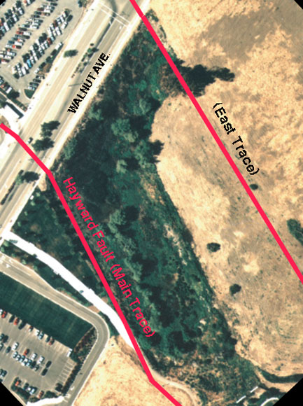
 Aerial photograph of Tysons Lagoon (Tule Pond) in southeast Fremont, CA. The northern half of the "Tule Pond" is covered by Walnut Ave., parking lots, and other developments shown at the top of this photograph. The red lines on this image are the approximate trends of both the Main Trace (left line) and East Trace (right line) of the Hayward Fault.
The purpose of this publication is to make available detailed trench logs, radiocarbon dates and pollen data obtained as a result of an intensive subsurface investigation of the Hayward Fault at Tyson's Lagoon (Tule Pond) from August to November 2000. The Hayward Fault is recognized to be among the most hazardous in the United States by the Working Group on California Earthquake Probabilities in 1999. This document makes available geologic evidence for historical and prehistoric surface rupturing earthquakes that were recorded at the site.
Prehistoric earthquakes deduced from geologic evidence are called paleoearthquakes. Establishing a chronology of paleoearthquakes is of immediate use in resolving the level of hazard posed by the Hayward Fault for producing large earthquakes in the future. Preliminary findings of this investigation have been presented in Lienkaemper and others in 2001. A formal report on our conclusions based on these data is in preparation. The investigation at Tyson's Lagoon is ongoing, so these products should not be considered final. Lienkaemper, Dawson, and Personius interpreted the geology and logged the trenches. Seitz and Reidy performed analyses on radiocarbon and pollen samples, respectively. Schwartz led the critical-review field team.
Previous trenching work was done at Tyson's Lagoon; Lienkaemper references the location of most of those trenches. The earlier trenching was generally for the evaluation of local fault rupture hazard, except for the 1992 study of Williams, which was a paleoearthquake investigation. An unpublished study by J.N. Alt in 1998 also sought evidence of paleoearthquakes. Alt's study and a 1970 study by Woodward-Clyde and Associates were located south of Walnut Avenue in one of the few areas that still remain undisturbed and were, thus, useful in planning our work in 2000.
Files available for download:
mf2386sh1.pdf - PDF (Portable Document Format) version of sheet 1 for viewing on screen (17.1 MB).
mf2386sh2.pdf - PDF version of sheet 2 for viewing on screen. (10.1 MB).
mf2386pamp.pdf - The descriptive pamphlet that accompanies sheets 1 and 2 as a PDF document (716 kb).
mf2386sh1.eps.gz - Encapsulated Postscript version of sheet 1 (compressed using gzip) for plotting. Size: 45 x 30 inches (76.5 MB; 93.4 MB uncompressed).
mf2386sh2.eps.gz - Encapsulated Postscript (EPS) version (compressed using gzip) of sheet 2 for plotting (34.6 MB; 41.3 MB uncompressed).
For questions about the scientific content of this report, contact James Leinkaemper.
Download a free copy of Adobe Reader
This report is available via print on demand.
| Help
| PDF help |
| Publications main page
| Miscellaneous Field Studies Maps |
| Department of the Interior
| U.S. Geological Survey |
| Geologic Division
| Earthquake Hazards Team|
| Privacy Statement
| Disclaimer
| Accessibility |
URL of this page is:
https://pubs.usgs.gov/mf/2002/2386/
Please send comments and suggestions, or report problems, to:
Michael Diggles
Created: February 2, 2002 (cad)
Updated: April 20, 2007 (bwr, mfd)