
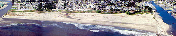
This oblique aerial photograph of Seabright Beach extends from the mouth of the San Lorenzo River (left) to the Santa Cruz Harbor jetty (right).
The coastal cliffs along much of the central California coast are actively retreating. Large storms and periodic earthquakes are responsible for most of the documented sea cliff slope failures. Long-term average erosion rates calculated for this section of coast do not provide the spatial or temporal data resolution necessary to identify the processes responsible for retreat of the sea cliffs where episodic retreat threatens homes and community infrastructure. Research suggests that more erosion occurs along the California coast over a short time scale, during periods of severe storms or seismic activity, than occurs during decades of normal weather or seismic quiescence.
This is the third map in a series of maps prepared to document the processes of short-term sea cliff retreat through the identification of slope failure styles, spatial variability of failures, and temporal variation in retreat amounts in an area that has been identified as an erosion hotspot. This map presents sea cliff failure and retreat data from the Seabright Beach section, California, which is located on the east side of Santa Cruz along the northern Monterey Bay coast. The data presented in this map series provide high-resolution spatial and temporal information on the location, amount, and processes of sea cliff retreat in Santa Cruz, California. These data show the response of the sea cliffs to both large magnitude earthquakes and severe climatic events such as El Niños; this information may prove useful in predicting the future response of the cliffs to events of similar magnitude. The map data can also be incorporated into Global Information System (GIS) for use by researchers and community planners. During this study we developed a method for investigating short-term processes of sea cliff evolution using rectified photographic stereo models. This method allows us to document the linear extent of cliff failures, the spatial and temporal relationship between failures, and the type or style of slope failure.
Seabright Beach extends 0.9 km from San Lorenzo Point on the west to the Santa Cruz Yacht Harbor on the east. The cliffs at Seabright Beach are completely protected from wave attack by a wide beach. The protective beach is a relatively recent feature that formed after the emplacement of the Santa Cruz Yacht Harbor jetty in 1963-1964. Prior to the completion of the jetty, the cliffs at Seabright Beach were subject to daily wave attack. The data in this study are post-jetty construction; therefore, the sea cliff failures and cliff retreat are the result of nonmarine processes (rainfall, groundwater and seismic shaking). The 8 to 15 m high cliffs at Seabright Beach are composed of the Miocene to Pliocene Purisima Formation, which is overlain by unconsolidated Pleistocene terrace deposits. The relative thickness of these units varies along the length of the cliff. At the west end of Seabright Beach, including San Lorenzo Point, nearly the entire cliff section is composed of Purisima Formation and is capped by less than 2 m of terrace deposits. In this exposure, the Purisima Formation is a moderately weathered, moderately indurated massive sandstone. The height of the cliffs and the thickness of the Purisima Formation decrease to the east. In the cliffs immediately adjacent to the harbor, the entire exposure is composed of terrace deposits. Toe-slope debris and wind-blown sand form a nearly continuous fan along the cliff base that obscure the lower portion of the cliff.
This study documents the impacts of earthquakes and large storms to the sea cliffs in the Seabright Beach section. The first event is the 1989 Loma Prieta earthquake, a M7.1 earthquake that caused widespread damage to the area stretching from Santa Cruz to the San Francisco Bay. The epicenter of the earthquake was located in the Santa Cruz Mountains, approximately 9 km inland from the coast. Extensive block and debris falls, induced by the seismic shaking, occurred along the sea cliffs in the study area. The second major event considered in this study is the 1997-98 El Niño that brought increased winter storm activity to the coastline of the northern Monterey Bay. Associated with these storms, which began in force in late January of 1998, were increased wave energy from more westerly directions than in non-El Niño years, elevated sea level, and increased amount and duration of precipitation. While increased wave energy and elevated sea level potentially have significant impacts on those portions of the cliffs that are exposed to waves, increased rainfall leading to excessive surface wash and increased groundwater pore pressures promote erosion of the sea cliffs.
The amount of cliff retreat for the Seabright Beach section was determined by digitizing the top edge of the cliff on the rectified photographic stereo models from October 1989 and from March 1998. The maximum retreat (5.8 m) along this stretch of coast from October 1989 to March 1998 is located at the west end of this section where there is now a retaining wall along the upper part of the cliff. The only other area that experienced any significant (greater than 2 m) retreat of the cliff edge is on the eastern part of the section, where the cliff retreated approximately 4.5 m. The amount that a particular section of cliff retreats in a given time period provides quantitative information that may be useful to land-use planning and land owners. While such retreat information is valuable, it provides little information on the processes of slope failure that lead to sea cliff retreat.
Three different types of slope failure were documented during the period from October 18, 1989 to March 6, 1998. These include debris falls, block falls, and debris flows. Rapid, seismically induced failures were either block or debris falls, resulting in failure of 90 m of the 0.9 km-long cliff section. The dominant failure type documented from the February 1998 imagery is debris flows of the terrace deposits. The period of severe storms in the several weeks prior to February 9, 1998, had the greatest impact on this stretch of coast. Over 213 m of the cliff failed during this period, predominantly by the process of debris flows involving the terrace deposits. During the last several weeks of the El Niño storm period, precipitation amounts dropped and storm intensities decreased. The response of the sea cliffs during this time was still significant; failures were documented along 165 m of the section. Debris flows and minor block falls were the two types of failures identified during this period.
This map has introduced new techniques of analyzing the short-term evolution of sea cliffs and the differential response of sea cliffs to seismic and climatic events. Using stereo models derived from softcopy photogrammetry, we are able to locate sea cliff failures to determine their spatial distribution and the geologic units involved for several different time periods in an area where sea cliff failure and retreat periodically threaten homes and community infrastructures. These data can be incorporated into a GIS database to examine the relationship of the failures to one another, to coastline morphology, and to field data (faults, joints, or lithologic changes). Spatial plots of the failures appear to show specific patterns; if additional data continue to support this observation, the technique of analyzing the temporal and spatial distributions of the cliff failures outlined in this study may help to identify areas prone to future failures.
Files available for downloads:
Download a PDF version of this map (1.4 MB)
Download an Encapsulated PostScript version of this map (101.4 MB)
For questions about the scientific content of this report, contact Cheryl Hapke
Download a free copy of Adobe Reader
This report is available via print on demand.
| Help
| PDF help |
| Publications main page
| Miscellaneous Field Studies Maps |
| Department of the Interior
| U.S. Geological Survey |
| Geologic Division
| Coastal and Marine Geology|
| Privacy Statement
| Disclaimer
| Accessibility |
URL of this page is:
https://pubs.usgs.gov/mf/2002/2400/
Please send comments and suggestions, or report problems, to:
Michael Diggles
Updated: April 23, 2007 (bwr, mfd)