
Image of the Hughes quadrangle geologic map, Alaska.
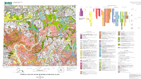
The Hughes quadrangle is at the interface between the Brooks Range to the north and the less rugged uplands and valleys of interior Alaska to the south. Southern foothills of the Brooks Range-principally the Angayucham Mountains, Helpmejack Hills, and Alatna Hills-extend across the northern part of the map area from west to east, and the east-west-trending Lockwood and Norutak Hills farther south form the south flank of the Kobuk River valley. The Hughes quadrangle is located near the south margin of continuous permafrost.
The late Cenozoic geologic record of the Hughes quadrangle reflects the complex interplay between glaciers that flowed south through broad mountain valleys of the Brooks Range and the barriers created by its generally east-west-trending southern foothills. The glacial sequence in the Hughes quadrangle consists of seven advances: these are grouped into four major glaciations that are named (from oldest to youngest) the Gunsight Mountain, Anaktuvuk River, Sagavanirktok River, and Itkillik glaciations from type localities along the north flank of the Brooks Range.
The Gunsight Mountain advance is the oldest glacial event recorded in the Hughes quadrangle. Farther east, it filled the Koyukuk basin, but it is recognized only in extreme eastern parts of the Hughes quadrangle. The drift has been highly eroded, and in many places is obscured by as much as 30-40 m of eolian and lacustrine silt. It is best exposed on high hilltops and ridge crests, where scattered and highly weathered granitic boulders and boulder fragments can be found. Drift remnants generally stand high above modern drainages, and also above the highest recognizable river terraces of Pleistocene age. The subsequent Anaktuvuk River advance is marked by more continuous arcuate end moraines with broad crests. These generally have thick covers of eolian and lacustrine silt and highly organic muskeg deposits. During the subsequent maximum advance of the Sagavanirktok River glaciation, valley glaciers from the Brooks Range extended south into the northern part of the Hughes quadrangle along the Kobuk and Alatna valley systems. The Itkillik glaciation had multiple phases and subphases within the south-central Brooks Range, but only the older advances of the Itkillik sequence extended south into the Hughes quadrangle.
This map and a companion map of the Bettles quadrangle complete a series of ten surficial geologic maps of the central Brooks Range and its foothills. The Hughes quadrangle extends much farther south of the Brooks Range than the areas mapped previously in this series; consequently its surficial geology is much more complex and more obscure. Diverse individual upland areas and depositional basins are present south of the Brooks Range; each has its own distinctive Quaternary geologic history, and several have their own separate glacial records. Very old unconsolidated deposits cover a large part of the map area. These have been extensively eroded in some places and typically are obscured beneath thick cover of silt or muskeg. Most of the map area also is heavily forested, obscuring surficial geologic deposits and causing access to be poor. In addition, sediments accumulating in depositional basins tend to form "stacked" or composite units (for example, glaciolacustrine deposits draped over a buried end moraine). Stacked units have been designated where significant subsurface deposits are evident in bluff exposures or can be inferred from physiography, erratic boulders, or other indirect evidence.
Files available for downloading:
Download this map as a PDF file; map size is 42 x 25 inches (7.3 MB)
Download this map as a Encapsulated PostScript file (29.3 MB)<
Download the pamphlet for this map as a PDF file (92 kb)
Download an ASCII text file version of the pamphlet, intended for use with screen readers
Download this digital database for this map as a gzipped tar file (3.8 MB)
Download the FGDC-compliant metadata for this report as an ASCII text file
For questions about the scientific content of this report, contact Thomas D. Hamilton
Download a free copy of Adobe Reader
This report is available via print on demand.
| Help
| PDF help |
| Publications main page
| Miscellaneous Field Studies Maps |
| Department of the Interior
| U.S. Geological Survey |
| Geologic Division
| Mineral Resources Team |
| Privacy Statement
| Disclaimer
| Accessibility |
URL of this page is:
https://pubs.usgs.gov/mf/2002/2408/
Please send comments and suggestions, or report problems, to:
Michael Diggles
Created: November 27, 2002 (cad)
Updated: April 20, 2007 (bwr, mfd)