
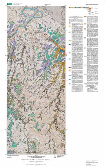
Geologic map of the combined Druid Arch and The Loop quadrangles, Canyonlands National Park, Utah.
This publication includes, in addition to cartographic and text products, geospatial (GIS) databases and other digital files. The database files are particularly useful because they can be combined with any type of other geospatial data for purposes of display and analysis. The other files include digital files that support the databases, and digital plot files that can be used to display and print the cartographic and text products in this publication.
The digital map database, compiled from previously published and unpublished data and new mapping by the author, represents the general distribution of bedrock and surficial deposits in the map area and provides current information on the geologic structure and stratigraphy of the area. The database delineates map units that are identified by age and lithology following the stratigraphic nomenclature of the U.S. Geological Survey. The scale of the source maps limits the spatial resolution (scale) of the database to 1:24,000 or smaller. The content and character of the database, as well as two methods of obtaining the database, are in the Readme file, available below.
mf2411.pdf - PFD (Portable Document Format) file of the map sheet for viewing onscreen (10.4 MB).
mf2411.eps - EPS (Encapsulated PostScript) file of the map sheet designed for plotting on a large format plotter. The map is 33 x 52 inches in size (58.4 MB).
readme.doc - Explanation of how to use the digital database (84 kb).
readme.pdf - PDF version of the digital database explanation (324 kb).
mf2411.met.txt - FGDC-compliant metadata for the database (24 kb).
mf2411c.zip - WinZipped compilation of all files necessary to recreate the database originally assembled in Arc/Info. Included is an AML called import.aml that will automatically import the Arc export files making up this database package (6.1 MB).
loopdruidarch.style - ArcMp style for map colors and symbolizing data (528 kB).
Mf2411_shapefiles.zip - Shapefiles and readme describing content of each file (5.2 MB).
For questions about the scientific content of this report, contact George Billingsley
Download a free copy of Adobe Reader
| Help
| PDF help |
| Publications main page
| Miscellaneous Field Studies Maps |
| Department of the Interior
| U.S. Geological Survey |
| Geologic Division
| Earth Surface Processes Team |
| Privacy Statement
| Disclaimer
| Accessibility |
URL of this page is:
https://pubs.usgs.gov/mf/2002/2411/
Please send comments and suggestions, or report problems, to:
Michael Diggles
Created: January 17, 2003 (cad)
Updated: June 4, 2007 (bwr, mfd)