| U.S. Geological Survey Miscellaneous Field Studies Map MF-2423 |
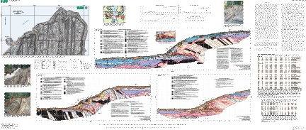
FIELD AND LABORATORY DATA FROM AN EARTHQUAKE HISTORY STUDY OF THE WATERMAN POINT FAULT, KITSAP COUNTY, WASHINGTON |
By Alan R. Nelson,1 Samuel Y. Johnson,1 Harvey M. Kelsey,2 Brian L. Sherrod,3 Ray E. Wells,4 Koji Okumura,5 Lee-Ann Bradley,1 Robert Bogar,6 and Stephen F. Personius1 |
1 U.S.
Geological Survey, Box 25046, Denver, CO 80225 |
 |
Version 1.0 |
| The text of this report is presented here in Portable Document Format. Adobe Acrobat Reader™ (5.0 or higher) or similar software is required to view it. If you wish to download the latest version of Acrobat Reader free of charge, click here. |
|
|
|
| A high-resolution plot of this publication can be purchased from Information Services, U.S. Geological Survey (1-888-ASK-USGS). |
| AccessibilityFOIAPrivacyPolicies and Notices | |
| |
|