

Introduction
The map area is in a remote region known as the Arizona Strip in northwestern Arizona about 20 mi north of Meadview, Arizona, the nearest settlement. Elevations range from about 6,748 ft on the Grand Gulch Bench (east-central edge of map area) to about 1,200 ft at Grand Wash (southwest corner of map area). Primary vehicle access is by dirt road and unimproved jeep trails that traverse various parts of the map area, except within the Grand Wash Wilderness Area of the Grand Gulch Bench (northeast corner of map area). Maps, extra fuel, two spare tires, and extra food and water are highly recommended when traveling in this remote region along with local U.S. Geological Survey 7.5 (topographic quadrangle maps (Grand Gulch Bench, Gyp Hills, Olaf Knolls, and Pakoon Springs) to accompany this map. Most of the map area is in the Grand Canyon Parashant National Monument, which is managed by the Bureau of Land Management through the Arizona Strip District Office in St. George, Utah. The southern part of the map area includes part of the Lake Mead National Recreation Area managed by the National Park Service at Boulder City, Nevada. The Grand Wash Cliffs Wilderness Area (northeast edge of map area) was designated in 1984 and is administrated by the Bureau of Land Management in St. George, Utah. Grand Canyon National Park lands are about 4 mi southeast of the map area. The Grand Gulch Bench area supports a sparse growth of sagebrush, cactus, grass, cliffrose bush, and Joshua, pinyon, and juniper trees. At lower elevations in the Grand Wash trough, a variety of sparse desert shrubs, grass, cactus, and Joshua trees are present. |
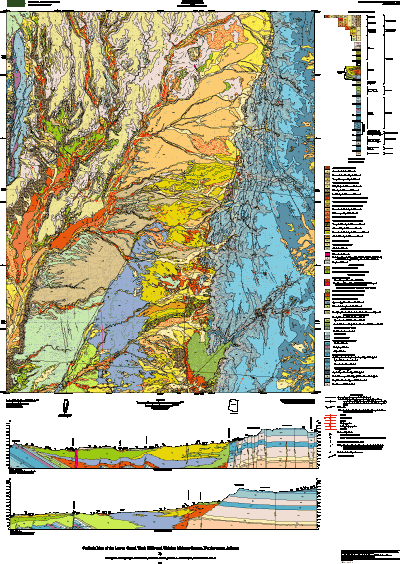 |
| Page-size version of geologic map of Lower Grand Wash Cliffs and vicinity. |
| File
Name |
File
Type and Description |
File
Size |
| README's
and METADATA |
||
| Readme file that gives information about the digital database |
4 Kb |
|
| Text file of the FGDC-compliant metadata |
40 Kb |
|
| DATA |
||
| Compressed tar file of the digital database for this map |
15.1 MB (expands to 245 MB) |
|
| FILES
for VIEWING and PLOTTING |
||
| PDF file of pamphlet to accompany this map | 280 KB | |
| PDF file of map sheet that can be used for viewing map in a browser, as well as for plotting | 32.9 MB |
|
For questions about the content of this report, contact George Billingsley
Download a current version of Acrobat Reader for free
| Help
| PDF help
| Geopubs main page |
| Western Miscellaneous Field Studies maps |
| Geologic Division |
Earth Surface Processes |
This report is also available from:
USGS Information Services, Box 25286,
Federal Center, Denver, CO 80225
telephone: 303-202-4210; e-mail: infoservices@usgs.gov
| U.S. Geological Survey | Privacy Statement | Disclaimer | Accessibility |
URL of this page: https://pubs.usgs.gov/mf/2004/2427/
Maintained by: Michael Diggles
Created: October 4, 2004
Last modified: May 26, 2005 (mfd)