U.S. Geological Survey Open-File Report 80–523
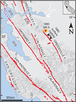 Left: Location of the 1980 surface ruptures on the Greenville fault. M 5.8 mainshock in 1980 shown by red star. Holocene active faults (red lines) from USGS and CGS and Lienkaemper and others for Hayward-Rodgers Creek fault connection. Abbreviations: CS, Concord section of Green Valley fault; RCF, Rodgers Creek fault; SF, San Francisco; SFB, San Francisco Bay, SPB, San Pablo Bay.
AbstractThe earthquakes of 24 January (Ms 5.8) 1980 north of Livermore, California, and 26 January (Ms 5.2), were accompanied by surface faulting in the Greenville fault zone and apparently in the Las Positas fault zone also. The surface faulting was discontinuous and of small displacement. The main rupture within the Greenville fault zone trended about N.38°W. It was at least 4.2 km long and may have extended southward to Interstate Highway 580, giving a possible length of 6.2 km; both of these lengths included more gaps than observed surface rupture. Maximum displacements measured by us were about 25 mm of right slip (including afterslip through 28 January); vertical components of as much as 50 mm were seen locally, but these included gravity effects of unknown amount. The main break within the Greenville fault zones is very close to a fault strand mapped by Herd (1977, and unpublished data). A subsidiary break within the Greenville fault zone was about 0.5 km. long, had a general trend of N.46°W., and lay 0.12 to 0.25 km east of the main break. It was characterized by extension of as much as 40 mm and right slip of as much as 20 mm. This break was no more than 25 m from a fault mapped by Herd (unpublished data). Another break within the Greenville fault zone lay about 0.3 km southwest of the projection of the main break and trended about N33°W. It was at least 0.3 km long and showed mostly extension, but at several places a right-lateral component (up to 5 mm) was seen. This break was 80 to 100 m from a strand of the Greenville fault mapped by Herd (1977). Extensional fractures within the Greenville fault zone on the frontage roads north and south of Interstate Highway 580 may be related to regional extension or other processes, but do not seem to have resulted from faulting of the usual kind. One exception in this group is a fracture at the east side of Livermore valley which showed progressive increase in right-lateral displacement in February and March, 1980, and is directly on the projection of a fault in the Greenville fault zone mapped by Herd (1977). A group of more than 20 extensional fractures in Laughlin Road 1 km north of Interstate 580 probably are related to small tectonic displacements on faults in the Greenville fault zone. They are adjacent and parallel to two faults mapped by Herd (1977), are diagonal to the road, and most of them developed between 25 and 29 January, a period that included the Ms 5.2 shock of 26 January. Observations at two locations indicate tectonic displacement on the Las Positas fault zone as mapped by Herd (1977). At Vasco Road a prominent break on a strand of the fault showed about 0.5 mm of left-lateral strike slip on 7 February. An alinement array across this and other fractures at the locality indicates about 6 mm of left-lateral displacement occurred between 21 February and 26 March. On Tesla Road several right-stepping fractures, one of which showed 1.5 mm of left-lateral strike slip, lie on or close tp previously mapped strands of the Las Positas fault zone. The evidence at these two localities indicates that tectonic surface displacement occurred along at least 1.1 km of the Las Positas fault zone. |
For additional information: This report is presented in Portable Document Format (PDF); the latest version of Adobe Reader or similar software is required to view it. Download the latest version of Adobe Reader, free of charge. |
Bonilla, M.G., Lienkaemper, J.J., and Tinsley, J.C., 1980, Surface faulting near Livermore, California associated with the January 1980 earthquakes: U.S. Geological Survey Open-File Report 80–523, 32 p., 1 plate, scale 1:24:000, available at http://pubs.usgs.gov/of/1980/0523/.
Abstract
Introduction
Surface Faulting
Summary
References Cited
one plate

![]() U.S. Department of the Interior |
U.S. Geological Survey
U.S. Department of the Interior |
U.S. Geological Survey
URL: http://pubsdata.usgs.gov/pubs/of/1980/0523/index.html
Page Contact Information: GS Pubs Web Contact
Page Last Modified: Thursday, 12-Apr-2012 13:12:20 EDT
