
By Michael F. Diggles1, Byron R. Berger2, Dean B. Vander Meulen1, Scott A. Minor3, Jay A. Ach4, and Michael G. Sawlan1
U.S. Geological Survey Open-File Report 89-531
1989
U.S. Department of the Interior
Manual Lujan Jr, Secretary
U.S. Geological Survey
Dallas L. Peck, Director
This report is preliminary and has not been reviewed for conformity with U.S. Geological Survey (USGS) editorial standards or with the North American Stratigraphic Code. Any use of trade, firm, or product names is for descriptive purposes only and does not imply endorsement by the U.S. Government.
1Menlo Park, CA 94025
2Spokane, WA 99201
3Denver, CO 80225
4San Francisco, CA 94112
This publication is an online version of U.S. Geological Survey Open-File Report 89-531. The data for this publication total 1.4 MB.
From 1984 to 1986, studies were conducted to assess the potential for undiscovered mineral resources in wilderness study areas on the Owyhee Plateau. The results of these studies have been published in a series of U.S. Geological Survey Bulletins. Since that time, low-grade, high-tonnage epithermal hot-spring gold-silver deposits have been recognized in the region north of the wilderness study areas. The recognition that this mineral-deposit model is applicable in the region, coupled with new data that has become available to the U.S. Geological Survey, reinterpretation of existing geochemical data, and known-deposit data suggest that similar deposits may be present elsewhere on the Owyhee Plateau. This report is an additional assessment of the Battle Creek, Bruneau River, Deep Creek-Owyhee River, Jarbidge River, Juniper Creek, Little Owyhee River, North Fork Owyhee River, Owyhee River Canyon, South Fork Owyhee River (ID-016-053), Upper Deep Creek, and Yatahoney Creek Wilderness Study Areas in Idaho Wilderness Study Areas in Idaho in light of those new data.
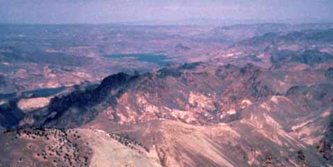
Mahogany Mountain caldera in southeastern Oregon. View looking north; Idaho study areas are to the left out of the picture. In the far background is Atlas Gold Corporation's Grassy Mountain deposit that contains one million ounces of reserves. U.S. Geological Survey photograph by James J. Rytuba.
This publication contains a Portable Document Format (PDF) file that contains 12 pages with three appendixes.
This report was produced in cooperation with Bureau of Land Management.

The report is provided as a PDF file for which you will need Adobe Acrobat Reader to view. You can download a copy of the latest version (5.0 at the time of this publication) by clicking the button above.
CLICK HERE to view the PDF file (of89-531.pdf) (1.3 MB).
CLICK HERE to view the version-history file for this report.
To contact the senior author, email Michael F. Diggles (mdiggles@usgs.gov).
Privacy
statement -- General
disclaimer
URL of this page: https://pubs.usgs.gov/of/1989/of89-531/
Maintained by: Michael Diggles
Created: February 28, 2002
Last modified: July 1, 2005 (mfd)