Publications—Open-File Report 93–480
Stream Stability and Scour Assessment at Bridges in Massachusetts
 By Linda P. Warren
U.S. Geological Survey Open-File Report 93–480
Prepared in cooperation with the Massachusetts Highway Department
The mission of the Water Resources Division of the U.S. Geological Survey (USGS) includes, in part, identifying potential water-related hazards and determining their causes and character, and providing information used by Federal and State agencies to assess the effects of these hazards on public health, safety, property, and the environment. This mission supports the overall mission of the U.S. Department of the Interior and the U.S. Geological Survey.
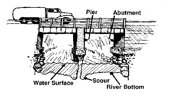
What is scour?
Scour is the hole left behind when sediment (sand and rocks) is washed away from the
bottom of a river. Although scour may occur at any time, scour action is especially strong
during floods. Swiftly flowing water has more energy than calm water to lift and carry
sediment down river.

Three types of scour affect bridges:
1) Local scour is removal of sediment from around bridge piers or abutments. (Piers are the pillars supporting a bridge. Abutments are the supports at each end of a bridge.) Water flowing past a pier or abutment may scoop out holes in the sediment; these holes are known as scour holes.
2) Contraction scour is the removal of sediment from the bottom and sides of the river. Contraction scour is caused by an increase in speed of the water as it moves through a bridge opening that is narrower than the natural river channel.
3) Degradational scour is the general removal of sediment from the river bottom by the flow of the river. This sediment removal and resultant lowering of the river bottom is a natural process, but may remove large amounts of sediment over time.
Why be concerned about scour?
If sediment, or rock on which bridge supports rest is scoured by a river, the bridge could become unsafe for travel. In 1987, the Interstate Highway bridge over Schoharie Creek in New York State collapsed during a flood. After this accident, the Federal Highway Administration required every State to identify highway bridges over water which are likely to have scour problems and to identify bridges where scour is severe. Knowledge of bridge sites where scour is a potential problem will enable the States to monitor and improve conditions at these bridges ahead of time-- before they become dangerous.
What is involved in a bridge-site examination?
A bridge-site examination for scour begins in the office of the Massachusetts Highway Department, where historical engineering information and bridge plans are reviewed. The examiner then visits the bridge site, walking upstream and downstream from the bridge and taking notes on the condition of the river channel. Other characteristics of the river are noted, such as locations of river bends near the bridge and what possible effects these may have on the bridge. Many things affecting scour are examined, such as the type of rock or sediment carried by the river and the angle at which the river flows toward and away from the bridge. The number of trees growing on the river banks also is noted because tree roots can help keep soil from being washed away. The area under and near a bridge is examined for scour holes and other evidence of scour.
Information gathered during the bridge-site examination is combined with pictures of the bridge into a computerized data base. The information in the data base is used to keep track of scour conditions at bridge sites throughout Massachusetts.
Approximately 2,500 highway bridges span water in Massachusetts. These bridges are being examined by hydrologists and hydrologic technicians from the USGS, Water Resources Division, USGS Massachusetts-Rhode Island Water Science Center Office, located in Marlborough, Massachusetts. The USGS is working in cooperation with the Massachusetts Highway Department and provides scour information to the Massachusetts Highway Department for each bridge examined. All of the bridge sites are scheduled to be examined for scour before 1996.
The Bridge Inspection Unit of the Massachusetts Highway Department is responsible for maintaining bridge structures.
Whom may I contact for more information?
For questions concerning the Bridge Scour Program, contact:
Director,
USGS Massachusetts–Rhode Island Water Science Center
10 Bearfoot Road
Northborough, MA 01532or visit our Web site at:
http://ma.water.usgs.gov
For questions concerning all other aspects of the bridges in Massachusetts, contact:
Michael W. Swanson, Chief Engineer
Massachusetts Highway Department
10 Park Plaza
Boston, MA 02116
Attention: Joseph P. Gill, Bridge Engineer Linda P. Warren Phone contact: Paul L. Nardone, Bridge Inspection Engineer
Phone: (617) 973-7574
Special thanks to Mrs. Bisol's fifth grade class at the John Greenleaf Whittier School in Haverhill, Massachusetts for their suggestions and comments regarding this publication.