U.S. Geological Survey Open-File Report 94-281
PRISM 8°x10° Northern Hemisphere Paleoclimate Reconstruction: Digital Data
Prism Project Members
(authorship is alphabetical)
Introduction
The PRISM 8°x10° data set represents several years of investigation by
PRISM (Pliocene Research, Interpretation, and Synoptic Mapping)
Project members. One of the goals of PRISM is to produce time-slice
reconstructions of intervals of warmer than modern climate within the
Pliocene Epoch. The first of these was chosen to be at 3.0 Ma (time scale
of Berggren et al., 1985) and is published in Global and Planetary Change
(Dowsett et al., in press). This document contains the actual data sets
and a brief explanation of how they were constructed. For
paleoenvironmental interpretations and discussion of each data set, see
Dowsett et al., in press. The data sets includes sea level, land ice
distribution, vegetation or land cover, sea surface temperature and sea-
ice cover matrices.
General Description
This reconstruction of middle-Pliocene climate is organized as a series of
datasets representing different environmental attributes. The data sets
are designed for use with the GISS Model II atmospheric general
circulation model (GCM) using an 8°x10° resolution (Hansen et al., 1983).
The first step in documenting the Pliocene climate involves assigning an
appropriate fraction of land versus ocean to each grid box (Figure 1).
Following grid cell by grid cell, land versus ocean allocations, winter
and summer sea ice coverage of ocean areas are assigned and then winter
and summer sea surface temperatures are assigned to open ocean areas.
Average land ice cover is recorded for land areas and then land areas not
covered by ice are assigned proportions of six vegetation or land cover
categories modified from Hansen et al. (1983). In the example shown in
Figure 1, the cell centered at 58.77° North latitude and 140° West
longitude (row 20, column 5) has 40% land coverage and 60% water
coverage. The water area in the cell is assigned winter (February) and
summer (August) sea surface temperature (SST) values of 8.6°C and 15.9°C
respectively. The land area in the cell has no land ice cover nor does
the water have any sea ice cover. Of the six land cover or vegetation
types in Table 1, the land area of this cell is covered 20% by deciduous
forest and 80% by evergreen vegetation.
Sea Level
We constructed an 8°x10° grid of estimated Pliocene sea-level by
determining the +25 m elevation in the NOAA ETOPO5 5-minute bathymetry/
topography digital relief data set of the world (NOAA National Geophysical
Data Center Data Announcement 88-MGG-02). Each elevational value
in the ETOPO5 grid was converted to either a value of one (the grid point
was at or above +25 m elevation) or zero (the grid point was below +25
m). A 1°x1° "presence-absence" grid for land was constructed by
determining the percentage of land within a given 1°x1° cell by summing
the number of 1's (from the 5-minute data) and dividing by the total
number of grid points (144). If the percentage value was less than 50%
land, then the cell was declared to be water and assigned a zero in the
1°x1° grid. If the percentage of land was 50% or greater, then the cell
was declared to be land and assigned a value of one in the 1°x1° grid.
The 1°x1° presence-absence matrix was then processed at NASA-GISS to
produce an 8°x10° percentage matrix (Fig. 2). The percentage of land in
each cell is scaled from 0 to 1.0 (complete coverage). These estimates of
coastline changes are based solely on elevation data and do not take into
account isostatic rebound associated with melting of ice sheets nor
elevation changes due to tectonic adjustments occurring since the Pliocene.
Sea Surface Temperature (SST)
SST data sets provide Pliocene surface temperatures for February and
March (Figs. 3-4). Temperatures range from -1.56 °C (sea-ice) to 30°C.
We constructed February and August SST data sets by determining the
deviation from modern conditions for all marine localities using
quantitative and qualitative assemblage data from planktic foraminifers,
diatoms, and ostracodes (Dowsett et al., in press). We then contoured and
smoothed these deviations for February and August to create 8°x10°
February and August anomaly maps. These anomalies were applied to modern
SST files to create Pliocene February and August SST Files (Figs. 3-4).
Sea Ice Distribution
For Pliocene Northern Hemisphere winter we used modern summer (August 1
through August 15) sea-ice conditions (U.S. Navy Hydrographic Office,
1958); average sea-ice concentrations >= 0.5 were used to approximate the
modern average ice open-water margin. The position of that margin in each
8°x10° grid cell determined the geographic coverage in the cell. Cells
with complete sea-ice cover were coded as 1.0, while cells with no sea-ice
cover were coded as 0.0 (Fig. 5). Our Pliocene summer reconstruction
incorporates an ice-free Arctic Ocean, thus Northern Hemisphere grid cells
containing ocean were coded as 0.0 indicating no coverage by sea-ice
(Fig. 6).
Pliocene sea-ice limits for the Southern Hemisphere (circumantarctic) were
estimated on the basis of existing Pliocene sea-surface temperature (SST)
and mean annual surface air temperature estimates. We estimated winter
(August) sea-ice limits to be similar to modern summer (February)
conditions. Average circumantarctic sea-ice concentrations of >= 0.6
were used to approximate the modern average ice-open water margin (Naval
Oceanography Command Detachment, 1985). [Note: Northern and southern
hemisphere sea-ice atlases use different sea ice concentration cutoffs.
Thus we used the >= 0.5 concentration for the northern hemisphere
and >= 0.6 concentration in the southern hemisphere to denote the sea-ice
open-water margin.] The position of that margin in each 8x10 grid cell
determined the geographic coverage in the cell. Cells with complete sea-
ice cover were coded as 1.0 while cells with no sea-ice cover were coded
as 0.0 (Fig. 6). As with the Northern Hemisphere, we assume the
circumantarctic was ice-free during the austral summer (February) (Fig. 5).
Land Ice Distribution
The Land Ice distribution data set provides information on Pliocene land-
ice coverage (Fig. 7). Grid cells completely covered by land ice are
coded with 1, cells without land ice are coded with 0. As discussed in
Dowsett et al., in press, we effectively removed all Northern Hemisphere
land ice except for 50% of the aerial cover of Greenland. We modified the
modern distribution of ice in southern hemisphere cells of the 8°x10° grid
using the Oerlemans (1982) models as a guide to represent removal of the
West Antarctic ice sheet and 25% reduction in the size of the East
Antarctic ice sheet (Figure 7). This land ice reduction provides the
necessary sea level rise for our sea level reconstruction.
Land Vegetation
The GISS model uses an eight-type vegetation classification to provide
hydrological and albedo parameters for model simulations (Hansen et al.,
1983). Desert, tundra, grassland, shrub grassland, tree grassland,
deciduous forest, evergreen forest, and rainforest are expressed as a
percentage of the total land cover in each cell containing land. For
modern vegetation, these percentages were obtained from a 1°x1° grid of 22
possible vegetation types (Matthews, 1985) in which each cell is
characterized by a single vegetation type. For the 8°x10° grid these
1°x1° cells are summed and divided by the total number of cells to produce
matrices of percentage of total land cover for each vegetation class. We
determined that it was too difficult to discern the differences among the
three grassland categories (all of which have similar albedo and hydrology
characteristics in the GISS parameterization) in the fossil data, and thus
these three classes were summed into a single "total grassland" category.
To construct the Pliocene 8°x10° vegetation grid we adjusted the values in
the modern grid to fit the broad geographic patterns in Pliocene
vegetation apparent in the paleobotanical data described in Dowsett et
al., in press. The modern value for an individual cell was adjusted by
taking into account what is known about Pliocene vegetation in that cell
(or if no data were available from that cell, from the nearest cell with
data). The modern and Pliocene vegetation on the GISS grid are presented
in Table 1.
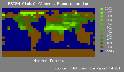
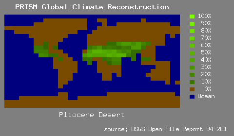
- Desert
- The desert category in the modern 8°x10° grid has two components --
polar desert and middle or low latitude desert. These vegetation
associations are grouped together for the numerical climate model because
they have similar albedo and hydrological characteristics. In the absence
of data constraining the areal extent of deserts we reduced the areal
extents around the peripheries of the modern deserts and approximately
halved their modern proportions within the other modern desert cells (
Figure 8, Table 1). The reductions in desert were largely made up by
increasing grassland/steppe proportions with these grid cells (see
discussion below).
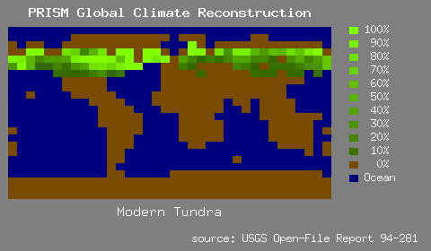
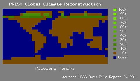
- Tundra
- For the GISS 8°x10° Pliocene vegetation grid, we concluded that tundra
was quite restricted at 3.0 Ma and it was entered as low levels of
abundance in the northernmost two rows of cells (Figure 9, Table 1).
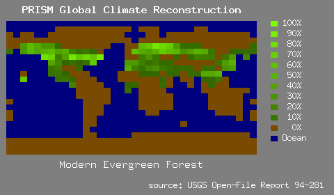
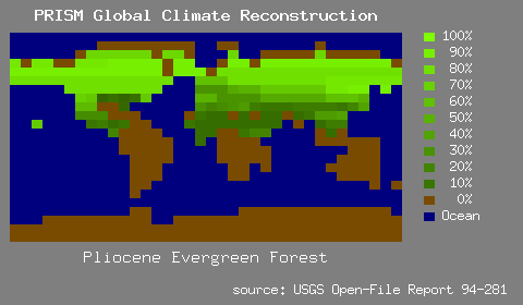
- Evergreen Forest
- For the Pliocene 8°x10° vegetation grid (Figure 10, Table 1) evergreen
forest was entered at high abundance in the higher latitude of North
America and Eurasia. In the western United States, Europe and
southwestern and central Asia, the percentage of evergreen vegetation was
increased (relative to modern) and its range extended.
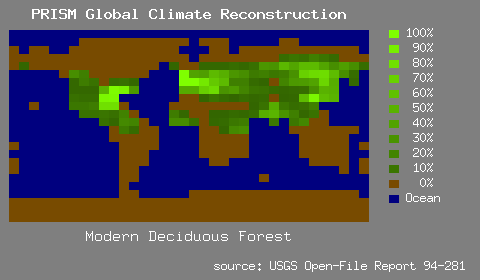
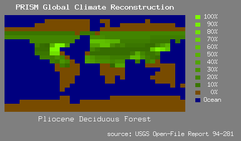
- Deciduous Forest
- We maintained the current centers of high abundance for deciduous
vegetation in the 8°x10° Pliocene vegetation grid (Figure 11, Table 1).
These persistent "centers of mass" for this vegetation category occur in
eastern North America, northwest Europe, and southern Asia. In addition,
Pliocene deciduous vegetation was increased (relative to today) in the
circum-Mediterrean region and east Africa. To reflect the occurrence of
deciduous trees in Pliocene boreal and temperate conifer forests, low
levels of deciduous vegetation were coded into grid cells as far north as
the latitude of the North Slope of Alaska.
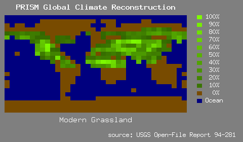
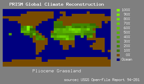
- Grassland
- Grassland as used here combines the GISS categories of grassland,
shrub-grassland (steppe), and tree-grassland (savanna) (Figure 12, Table
1). For the Pliocene, modern grassland and steppe vegetation was
maintained at reduced abundance in central North America and in parts of
central Asia and Africa. The abundance of the grassland category was
increased for the modern mid/low latitude desert regions (see discussion
in Dowsett et al., in press).
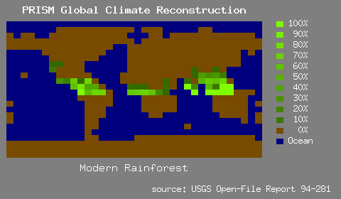
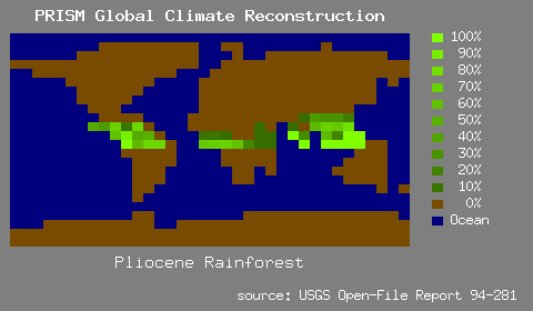
- Rain Forest
- For the 8°x10° grid (Figure 13, Table 1), the modern distribution of
rain forest was used with only minor modification for smoothness.
Bibliography
- Berggren, W.A., Kent, D.V., and Van Couvering, J.A., 1985. Neogene geochronology and chronostratigraphy In: N.J. Snelling (Editor), The Chronology of the Geological Record. London, Blackwell Scientific Publications, pp. 211-260.
- Dowsett, H.J., Thompson, R.S., Barron, J.A., Cronin, T.M., Fleming, F., Ishman, S.E., Poore, R.Z., Willard, D.A. and Holtz, T.R., Jr., in press. Paleoclimate reconstruction of a warmer Earth: PRISM Middle Pliocene Northern Hemisphere synthesis. Global and Planetary Change : 49pp.
- Hansen, J., Russell, G., Rind, D., Stone, P., Lacis, A., Lebedeff, S., Ruedy, R., Travis, L., 1983. Efficient three-dimensional global models for climate studies: models I and II. Monthly Weather Review 111(4): 609-662.
- Matthews, E., 1985. Prescription of land-surface boundary conditions in GISS GCM II: a simple method based on high-resolution vegetation data bases. NASA Report No. TM 86096 : 20 p.
- Naval Oceanography Command Detachment, 1985. Sea Ice Climate Atlas, vol. 1, Antarctica. NAVAIR 50-1C-540.
- Oerlemans, J., 1982. Response of the Antarctic ice sheet to a climatic warming: a model study. Journal of Climatology, 2: 1-11.
- U.S. Navy Hydrographic Office, 1958. Oceanographic Atlas of the Polar Seas, Part II: Arctic.
Contact Information
Names and addresses are provided as points of contact for various data
sets discussed above. Areas of specific knowledge for both underlying
science and data manipulation associated with each data set are given
using the following codes: ST for Sea Surface Temperature; SI for Sea
Ice; SL for Sea Level; VG for Vegetation; LI for Land Ice; OV for
general overview of all data sets.
John A. Barron  [ST,SI,SL]
Mail Stop 915
U.S. Geological Survey
345 Middlefield Road
Menlo Park, CA 94025
Tel: (415) 329-4971
Email: jbarron@usgs.gov
Thomas M. Cronin  [ST,SI,SL]
Mail Stop 970
U.S. Geological Survey
12201 Sunrise Valley Drive
Reston, VA 22092
Tel: (703) 648-6363
Email: tcronin@usgs.gov
Harry J. Dowsett  [ST,SL,OV]
Mail Stop 970
U.S. Geological Survey
12201 Sunrise Valley Drive
Reston, VA 22092
Tel: (703) 648-5282
Email: hdowsett@usgs.gov
R. Farley Fleming  [VG]
Mail Stop 919
U.S. Geological Survey
P.O. Box 25046
Denver Federal Center
Denver, Colorado  80225-0046
Tel: (303) 236-5681
FAX: (303) 236-5690
Email: ffleming@usgs.gov
Thomas R. Holtz, Jr. [SI]
Mail Stop 970
U.S. Geological Survey
12201 Sunrise Valley Drive
Reston, VA 22092
Scott E. Ishman  [LI,SI]
Mail Stop 970
U.S. Geological Survey
12201 Sunrise Valley Drive
Reston, VA 22092
Tel: (703) 648-5316
Email: sishman@usgs.gov
Richard Z. Poore  [ST,SI]
Mail Stop 955
U.S. Geological Survey
12201 Sunrise Valley Drive
Reston, VA 22092
FAX: (703) 648-6647
email: rpoore@usgs.gov
Robert S. Thompson [VG,SL,OV]
Mail Stop 919
U.S. Geological Survey
P.O. Box 25046
Denver Federal Center
Denver, Colorado  80225-0046
Tel: (303) 236-0439
FAX: (303) 236-5690
Email: rthompson@usgs.gov
Debra A. Willard  [VG]
Mail Stop 970
U.S. Geological Survey
12201 Sunrise Valley Drive
Reston, VA 22092
Tel: (703) 648-5320
email: dwillard@usgs.gov
U.S. Geological Survey Global Change Research Program
This page is <https://pubs.usgs.gov/openfile/of94-281/Derived/report.html>
Created and maintained by Eastern Publications Group Web Team
Last updated 28-Feb-2001