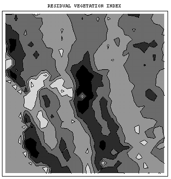
We have mapped the contours of
vegetation
and the
residuals
from a model predicting vegetation from topography (elevation, slope, and aspect) and climate (temperature and precipitation). We can think of the vegetation map as a picture of vegetation with all possible determining factors included, and the residual map as a picture that includes only topographic and climatic influences. The residuals therefore reflect other major factors, particularly "error" as well as human activities.
These maps show several things:
- The overall patterns are generally similar, with strong NNE-SSW ridges to vegetation, following the topography.
- On the other hand, the statistical modeling has significantly redistributed predicted vegetation.
- The residual vegetation index in the Sierras and the northern Coast Range is lower than the actual value because of the influence of climatic factors.
- There is a strong concentration of residual vegetation in the Central Valley and especially in the Delta areas.
Much of the pattern that remains is probably due to the human activities that were noted above in the quantitative results to be important statistical determinants of vegetation patterns.